
中文词条参见链接(无法从中国内地访问):点击这里访问。
英文词条参见链接(无法从中国内地访问):点击这里访问。
本文基于英文词条的线索,并补充部分来自中文词条的内容。辽观搬运时进行了必要的合规化处理,以使其能够在中国内地上传。
维基百科(Wikipedia)是美国维基媒体基金会的互联网百科项目,其内容可能受到立场、信息来源等因素影响,请客观看待。正文内容不代表译者观点。
辽观提供的译文仅供参考。
文中可能包含无法从中国内地访问的链接。
辽观所搬运的词条与原维基百科词条同样遵循CC-BY-SA 4.0协议,在符合协议要求的情况下您可以免费使用其内容(包括商用)。
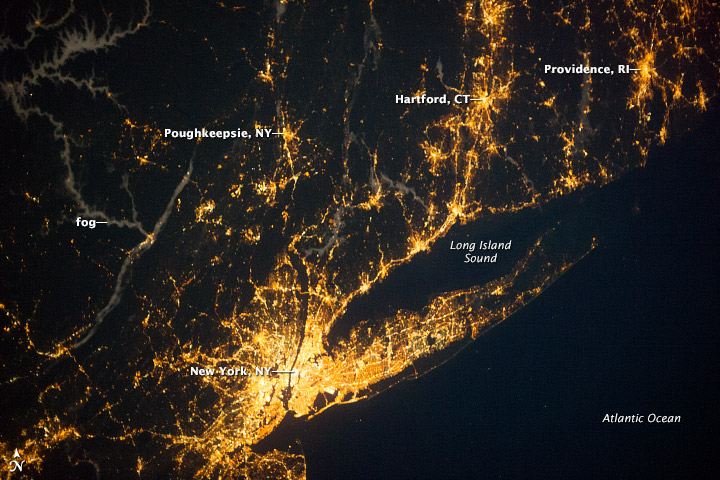
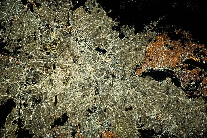
封面图片:Satellite image of the New York metropolitan area, the largest metropolitan area in the United States and one of the largest in the world, with Long Island in the east and Manhattan in the image’s center(纽约大都市区的卫星图像,是美国最大的大都市区,也是世界上最大的大都市区之一,长岛在东部,曼哈顿在图像的中心) 图片来源:http://earthobservatory.nasa.gov/IOTD/view.php?id=82155
0. 序言[1]
都市区(英语:metropolitan area; metropolitan coordinating region)又称都会区、都市圈,是指以大都市的中央城区为核心,向周围市郊、远郊、卫星城、边缘区的集镇、村镇、乡村等地区蔓延构成一个受同一行政区划管辖的复合城市集合区域。都市圈的特点反映在其各个聚居地之间紧密的经济联系、产业的分工与合作,交通与社会生活、城市规划和基础设施建设相互影响。
北美地区的“metropolitan area”在中文里一般译作“大都会”、“大都市区”或“都会区”。
A metropolitan area or metro is a region consisting of a densely populated urban agglomeration and its surrounding territories sharing industries, commercial areas, transport network, infrastructures and housing.[1][2] A metropolitan area usually comprises multiple principal cities, jurisdictions and municipalities: neighborhoods, townships, boroughs, cities, towns, exurbs, suburbs, counties, districts and even states and nations in areas like the eurodistricts. As social, economic and political institutions have changed, metropolitan areas have become key economic and political regions.[3]
参考译文:都会区或城市群是由人口密集的城市聚集区及其周边地区共享产业、商业区、交通网络、基础设施和住房的一个地域。都会区通常包括多个主要城市、管辖区域和自治市镇:如邻里社区、乡镇、自治市镇、城市、市镇、市郊、县、区域,甚至是像欧洲区域一样的国家和地区。随着社会、经济和政治制度的变化,都会区已成为重要的经济和政治地区。
Metropolitan areas typically include satellite cities, towns and intervening rural areas that are socioeconomically tied to the principal cities or urban core, often measured by commuting patterns.[4] Metropolitan areas are sometimes anchored by one central city such as the Paris metropolitan area (Paris) or Mumbai Metropolitan Region (Mumbai). In other cases, metropolitan areas contain multiple centers of equal or close to equal importance, especially in the United States; for example, the Dallas–Fort Worth metropolitan area has eight principal cities. The Islamabad–Rawalpindi metropolitan area (Islamabad and Rawalpindi), the Rhine-Ruhr in Germany and the Randstad in the Netherlands are other examples.[5]
参考译文:都会区通常包括卫星城市、城镇和与主要城市或城市核心有社会经济联系的农村地区,常通过通勤模式来衡量[4]。都会区有时由一个中心城市作为锚点,例如巴黎都会区(巴黎)或孟买都会区(孟买)。在其他情况下,都会区包含多个重要程度相当或接近的中心,特别是在美国;例如,达拉斯-沃斯堡都会区有八个主要城市。伊斯兰堡-拉瓦尔品第都会区(伊斯兰堡和拉瓦尔品第)、莱茵-鲁尔区(德国)和兰斯塔德都会区(荷兰)是其他例子[5]。
大都市区包括了市区(连续的建成区)和可能不具城市特色的区域,但这些区域通过就业或其他商业活动与中心紧密相连。这些边远区域有时被称为通勤带(commuter belt),可能远远超出城市区域,延伸到其他行政区。例如,纽约长岛的艾斯利普被认为是纽约大都会区的一部分。
实际使用中,官方和非官方的大都市区的界限都不尽相同。有时它们与市区(urban area)差别不大,而有时它们覆盖的区域与单一的城市聚落没什么关系;大都市区的比较统计数据应当考虑到这一点。即使对同一个都市区,其人口统计数字之间也可能相差上百万。
英语中,自1950年采用以来,大都市区(metropolitan areas)的基本概念没有发生明显变化,[1]不过地理分布则有明显变化,并且未来还可能会有更多变化。[2]由于“大都市统计区”(metropolitan statistical area)一词的不稳定性,人们使用的更通俗的术语是“城市服务区”(metro service area)、“都市区”(metro area)或“MSA”,不仅包括城市,还包括郊区,远郊,有时还包括农村地区,这些都被认为会有影响。多中心都市区包含多个不连续发展的城市集聚区(urban agglomeration)。定义都市圈时,仅需一个或多个城市形成一个核心,而其他区域与之高度融合。
In the United States, the concept of metropolitan statistical areas has gained prominence. The area of the Greater Washington metropolitan area is an example of statistically grouping independent cities and county areas from various states to form a larger city because of proximity, history and recent urban convergence. Metropolitan areas may themselves be part of a greater megalopolis. For urban centres located outside metropolitan areas that generate a similar attraction at a smaller scale for a region, the concept of a regiopolis and a respective regiopolitan area, or regio, was introduced by German professors in 2006.[6] In the United States, the term micropolitan statistical area is used.
参考译文:在美国,都会统计区的概念变得越来越重要。大华盛顿都会区的范围是一个例子,它统计了来自不同州的独立城市和县区,形成一个更大的城市,因为它们之间的接近性、历史和最近的城市融合。都会区本身可能是一个更大的大都市区的一部分。对于位于都会区之外的城市中心,在该地区以较小尺度产生类似吸引力的情况下,德国教授在2006年引入了“区域都市”和相应的区域都市区或区域(Regio)的概念。在美国,使用“微型统计区”这个术语。
1. 定义 Definition
1.1 定义的发展
A metropolitan area combines an urban agglomeration with the contiguous built-up areas, which are not necessarily urban in character but are closely bound to the center by employment or other commerce. These outlying zones are sometimes known as a commuter belt and may extend well beyond the urban zone to other political entities. For example, East Hampton, New York, on Long Island is considered part of the New York metropolitan area.
参考译文:都会区将城市聚集区与连续的建成区域结合在一起,这些区域不一定具有城市特征,但通过就业或其他商业活动与中心区紧密联系在一起。这些周边区域有时被称为通勤带,可能延伸到城市区域以外的其他政治实体。例如,纽约州长岛上的东汉普顿被认为是纽约都会区的一部分。
In practice, the parameters of metropolitan areas, in both official and unofficial usage, are not consistent. Sometimes they are little different from an urban area, and in other cases, they cover broad regions that have little relation to a single urban settlement; comparative statistics for metropolitan areas should take this into account. The term metropolitan can also refer to a county-level municipal government structure, with some shared services between a central city and its suburbs, which may or may not include the entirety of a metropolitan area. Population figures given for one metro area can vary by millions.
参考译文:实际上,都会区的参数在官方和非官方的使用中并不一致。有时,它们与城市地区几乎没有区别,而在其他情况下,它们涵盖了与单个城市定居点几乎没有关系的广泛地区;对于都会区的比较统计数据应该考虑到这一点。术语“都会”也可以指县级市政府结构,中心城市和其郊区之间共享一些服务,可能包括或不包括整个都会区的全部范围。给出的一个都会区的人口数据可能会相差几百万。
There has been no significant change in the basic concept of metropolitan areas since its adoption in 1950,[7] although significant changes in geographic distributions have occurred since then, and more are expected.[8] Because of the fluidity of the term “metropolitan statistical area”, the term used colloquially is more often “metro service area”, “metro area”, or “MSA”, taken to include not only a city but also the surrounding suburban, exurban and sometimes rural areas, all of which the city is presumed to influence. A polycentric metropolitan area contains multiple urban agglomerations not connected by continuous development. In defining a metropolitan area, it is sufficient that a city or cities form a nucleus with which other areas have a high degree of integration.
参考译文:自1950年采用以来,都会区的基本概念并没有发生重大变化,虽然自那时以来地理分布发生了重大变化,并且预计还会有更多变化。由于“都会统计区”这个术语的流动性,口语中更常用的术语通常是“都会服务区”、“都会区”或“MSA”,这些术语不仅包括城市本身,还包括周围的郊区、外郊区和有时田园地区,都被认为受到城市的影响。一个多中心都会区包括多个不通过连续发展相连的城市聚集区。在定义一个都会区时,足够的条件是一个或多个城市形成一个核心,其他地区与之高度融合。
A metropolitan area is commonly known and characterized by a high concentration in service sector labor and enterprises.[9][10] Macroeconomics views metropolitan areas as trade regions of economic significance.[11]
参考译文:大都市区通常以服务业劳动力和企业高度集中为特征。[9][10]宏观经济学将都市圈视为具有经济意义的贸易区域。[11]
1.2 汉语语境中的定义分歧
1.2.1 台湾
主条目:台湾都会区

在同一区域内,由一个或一个以上之中心城市为核心,连结与此中心城市在社会、经济上合为一体之市、镇、乡(称为卫星市镇)所共同组成之地区,且其区内人口总数达三十万人以上。
1.2.2 中国大陆
维基文库中相关的原始文献:国家发展改革委关于培育发展现代化都市圈的指导意见
中国大陆过去对“都市圈”“都会区”“城市群”“大都市圈”等概念并无严格区分,其中“城市群”为中国大陆自1990年代以后常用的地域经济用语,但也常直接借用日文“都市圈”来表示同一概念,日文“都市圏”即英文“metropolitan coordinating region”之含义。2019年2月19日,国家发展改革委发布《国家发展改革委关于培育发展现代化都市圈的指导意见》,其中“都市圈”被定义为“城市群内部以超大特大城市或辐射带动功能强的大城市为中心、以1小时通勤圈为基本范围的城镇化空间形态”[3],从官方上定义了“都市圈”。
而事实上,一些更早的规划已经将“都市圈”等作为“城市群”的次一层级,例如《珠江三角洲城镇群协调发展规划(2004-2020)》《珠江三角洲城乡规划一体化规划(2009—2020年)》中将珠江三角洲城市群分为广佛肇都市区、深莞惠都市区、珠中江都市区[4];2016年的《长江三角洲城市群发展规划》提出了“一核五圈四带”,其中“五圈”是指“推动南京都市圈、杭州都市圈、合肥都市圈、苏锡常都市圈、宁波都市圈的同城化发展”。[5]
《中国都市圈发展报告2018》指出,除港澳台之外,全国共有34个中心城市都市圈,占到全国总面积的24%,总人口的59%,GDP的77.8%。根据发展水平差异,报告将这些都市圈分为成熟型、发展型和培育型三个层级,其中,长三角和珠三角范围内的7个都市圈发展最为成熟,已经形成连绵成片、互相重叠的城市连绵区。
- 成熟型都市圈:长三角连绵区包括上海市、杭州市、南京市、宁波市为中心城市的城镇密集区域,在都市圈发展水平、中心城市贡献度、同城化机制三个方面位于全国首位,都市圈联系强度方面位于全国第二。珠三角连绵区指以广州市都市圈和深圳市都市圈所在区域,发展质量仅次于长三角,但在内部城市之间联系度上优于长三角。
- 发展型都市圈:16个,除首都都市圈包含北京和天津两个中心城市之外,其余都市圈均为单一中心城市,这些中心城市分别为合肥、青岛、成都、西安、郑州、厦门、济南、武汉、石家庄、长春、太原、长沙、贵阳、南宁、沈阳。
- 培育型都市圈:11个,各自所在区域的中心城市分别为南昌、昆明、重庆、哈尔滨、大连、乌鲁木齐、福州、呼和浩特、银川、兰州-西宁[6]。
除去长三角和珠三角连绵区,一些发展型都市圈在一些单项排名中很突出。在都市圈发展水平排名中,首都都市圈、青岛都市圈、厦门都市圈排名靠前。报告认为,首都都市圈之所以低于长三角和珠三角主要在于北京市的辐射带动作用更多体现在全国尺度,其次,河北相关城市与北京和天津相比存在断层,拉低整体发展水平[7]。
2019年6月24日,中国社会科学院财经院、中国社科院城市与竞争力研究中心联合发布《中国都市圈报告》,从综合经济竞争力、可持续竞争力、营商竞争力及宜居竞争力四个维度,对18个发展较为完善的都市圈进行了测评。结果显示,粤港澳大湾区与长三角城市连绵区两大“头部”都市圈竞争激烈,整体表现最为出色。与此同时,青岛都市圈、厦门都市圈也以“黑马”之姿突出重围,在四个榜单中都稳居前五强。其中,两大都市圈在可持续竞争力、宜商竞争力及宜居竞争力上甚至都超过首都都市圈。[8]
1.2.3 香港
主条目:香港市区 § 都会区
根据香港政府的定义,香港的都会区指香港岛(及邻近岛屿)、九龙半岛和荃湾新市镇(即葵青区及荃湾区扣除马湾和北大屿山外的地区)。
新界地区如沙田区、大埔区、北区、西贡区、元朗区、屯门区、离岛区以及属于荃湾区的马湾及北大屿山并不是香港的市中心,因此不算是香港的都会区。
1.2.4 日本

主条目:都市圈 (总务省)
参见:城市雇用圈
在日本,各个政府部门对“都市圈”的定义有所出入。总务省统计局的国势调查(人口普查)中,都市圈是为了定义的广域的城市区域,超越行政区域而设定的统计上的地域区分。俗称“1.5%都市圈”。
2. 非洲 Africa
2.1 南非 South Africa
The Greater Johannesburg metropolitan area is the largest metropolitan area in South Africa. Its population was over 9.6 million as of the 2011 South Africa Census, in contrast to its urban area, which consisted of approximately 7.9 million inhabitants as of 2011. Conversely, metropolitan municipalities in South Africa are defined as commonly governed areas of a metropolitan area. The largest such metropolitan municipal government entity in South Africa is the City of Johannesburg Metropolitan Municipality, which presided over nearly 5 million people as of 2016. However, the Greater Johannesburg metropolitan area houses roughly ten times the population of its core municipal city of Johannesburg, which contained 957,441 people as of the 2011 census.
参考译文:大约翰内斯堡都会区是南非最大的都会区,截至2011年南非人口普查,其人口超过960万,与之形成对比的是,截至2011年的城市地区人口约为790万。相反,南非的都会市政府被定义为都会区中常规统治的地区。南非最大的都会市政府实体是约翰内斯堡都会市政府,截至2016年管理着近500万人口。然而,大约旺角都会区的人口大约是其核心市政府约翰内斯堡市的十倍,截至2011年人口普查时约为957,441人。
3. 美洲 Americas
3.1 巴西 Brazil
The following paragraph is an excerpt from List of metropolitan areas in Brazil § Definitions.[edit]
In Brazil, the terms metropolitan area (Portuguese: região metropolitana) and urban agglomeration (aglomeração urbana) have specific meanings. They are defined by federal and state legislation as collections of municipalities focused on “integrating the organization, planning and execution of public functions of common interest”.[12] An integrated development area (região integrada de desenvolvimento) is one of the two above structures that crosses state (or Federal District) boundaries.
参考译文:在巴西,都会区(葡萄牙语:região metropolitana)和城市聚集区(aglomeração urbana)这两个术语具有具体的含义。它们被联邦和州法规定义为以“整合组织、规划和执行公共利益事务”为重点的市镇集合体。综合发展区(região integrada de desenvolvimento)指的是跨越州(或联邦区)边界的这两种结构之一。
The IBGE defines also “Immediate Geographic Areas” (formerly termed microregions) which capture the region “surrounding urban centers for the supply of immediate needs of the population”.[13] Intended for policy planning purposes, as of March 2021 census data is not tabulated on the level of these Areas, but instead at the municipality or state level.[14]
参考译文:巴西国家地理和统计研究所(IBGE)还定义了“即时地理区域”(以前称为微区域),用于捕捉“为满足人口的紧急需求而环绕城市中心的地区”。[13] 作为政策规划的目的,截至2021年3月的人口普查并未按照这些地区的级别进行统计,而是按照市镇或州级别进行统计。[14]
3.2 墨西哥 Mexico
Further information: Metropolitan areas of Mexico
参考译文:更多信息请看:墨西哥大都市地区
Metropolitan areas are known as zonas metropolitanas in Mexico. The National Population Council (CONAPO) defines them as:[15]
参考译文:在墨西哥,大都市区被称为“zonas metropolitanas”。国家人口委员会(CONAPO)将其定义为:[15]
- a set of two or more municipalities where a city with a population of at least 100,000 is located, and whose urban area, functions and activities exceed the limits of the municipality.
参考译文:一个人口在10万以上的城市所在的两个以上的直辖市,其城市面积、功能和活动超出该直辖市的范围。 - municipalities with a city of more than 500,000 inhabitants, or a city of more than 200,000 inhabitants located in the northern and southern border areas and in the coastal zone.
参考译文:南北边境和沿海地区城市人口50万以上或者城市人口20万以上的直辖市。 - municipalities where state capitals are located, if they are not already included in a metropolitan zone.
参考译文:州首府所在的市镇,如果他们还没有包括在大都市区内。
As of 2018, there are 74 zonas metropolitanas in Mexico. 75.1 million people, 62.8% of the country population, live within a metropolitan area.[15]
3.3 美国 United States
Main article: Metropolitan statistical area
主要条目:都市统计区域
See also: List of U.S. metropolitan areas by GDP
参见:按GDP排序的美国大都市地区列表
As of February 28, 2013, the United States Office of Management and Budget (OMB) defined 1,098 statistical areas for the metropolitan areas of the United States and Puerto Rico.[16] These 1,098 statistical areas comprise 929 Core-Based Statistical Areas (CBSAs)[17] and 169 Combined Statistical Areas (CSAs).[18] The 929 Core-Based Statistical Areas are divided into 388 Metropolitan Statistical Areas (MSAs – 381 for the U.S. and seven for Puerto Rico)[19] and 541 Micropolitan Statistical Areas (μSAs – 536 for the U.S. and five for Puerto Rico).[20] The 169 Combined Statistical Areas (166 for the U.S. and three for Puerto Rico) each comprise two or more adjacent Core Based Statistical Areas.
参考译文:截至2013年2月28日,美国管理与预算办公室(OMB)为美国和波多黎各的都会区定义了1,098个统计区域。这些1,098个统计区域包括929个基于核心的统计区域(CBSAs)和169个组合统计区域(CSAs)。这929个基于核心的统计区域分为388个都会统计区域(MSAs – 美国为381个,波多黎各为七个)和541个微型都会统计区域(μSAs – 美国为536个,波多黎各为五个)。这169个组合统计区域(美国为166个,波多黎各为三个)每个都由两个或更多相邻的基于核心的统计区域组成。
The Office of Management and Budget defines a Metropolitan Statistical Area as one or more adjacent counties or county equivalents that have at least one urban area of at least 50,000 population, plus adjacent territory that has a high degree of economic and social integration with the core as measured by commuting ties. The OMB then defines a Combined Statistical Area as consisting of various combinations of adjacent metropolitan and micropolitan statistical areas with economic ties measured by commuting patterns. The Office of Management and Budget further defines a core-based statistical area (CBSA) to be a geographical area that consists of one or more counties (or equivalents) anchored by an urban center of at least 10,000 people plus adjacent counties that are socioeconomically tied to the urban center by commuting.
参考译文:美国管理与预算办公室将都会统计区域定义为一个或多个相邻的县或县等价物,其中至少有一个人口至少为50,000人的城市地区,以及通过通勤联系与核心地区在经济和社会上高度融合的相邻领土。然后,美国管理与预算办公室将组合统计区域定义为由相邻的都会统计区域和微型都会统计区域的不同组合组成,其经济联系由通勤模式来衡量。美国管理与预算办公室进一步将基于核心的统计区域(CBSA)定义为由一个或多个县(或等价物)组成的地理区域,其核心是至少有10,000人口的城市中心,且通过通勤与该城市中心在社会经济上相互关联。
4. 亚洲太平洋地区 Asia and Pacific
4.1 澳大利亚 Australia
The Australian Bureau of Statistics uses Greater Capital City Statistical Areas (GCCSAs), which are geographical areas designed to represent the functional extent of each of the eight state and territory capital cities. They were designed to reflect labor markets, using the 2011 Census “travel to work” data. Labor markets are sometimes used as proxy measures of the functional extent of a city as it contains the majority of the commuting population. GCCSAs replaced “Statistical Divisions” used until 2011.[21][5]
参考译文:澳大利亚统计局使用大都会城市统计区域(GCCSAs),这些地理区域旨在代表澳大利亚八个州和地区的首府城市的功能范围。它们旨在反映劳动力市场,使用2011年人口普查的“通勤到工作地点”的数据。劳动力市场有时被用作城市功能范围的代理测量,因为它包含了大部分通勤人口。GCCSAs取代了2011年前使用的“统计区划”。
Other metropolitan areas in Australia include cross border cities or continuous built-up areas between two or more cities that are connected by an extensive public transport network that allows for commuting for work or services. The following are such conurbations[citation needed]-
参考译文:澳大利亚的其他都会区域包括跨境城市或两个或多个城市之间连续建设的区域,这些城市之间通过广泛的公共交通网络连接,方便通勤工作或服务。以下是一些这样的都市区(需要引用)-
- Albury–Wodonga 奥尔伯里-沃东加
- Canberra–Queanbeyan 堪培拉-昆安比恩
- Newcastle–Sydney–Wollongong 纽卡斯尔-悉尼-伍伦贡
- Perth–Mandurah 珀斯-曼杜拉
- South East Queensland 东南昆士兰
- Melbourne–Geelong 墨尔本-吉朗
4.2 孟加拉国 Bangladesh
In Bangladesh, the large population centers which have significant Financial, political and administrative Importance are considered to be as Metropolitan cities, which are governed by City Corporations. In total, there are 12 City Corporations in Bangladesh.[22] 4 of them (Dhaka North City Corporation, Dhaka South City Corporation, Narayanganj City Corporation, Gazipur City Corporation) are part of Greater Dhaka Conurbation.
参考译文:在孟加拉国,具有重要金融、政治和行政意义的人口中心被视为都会城市,由城市公司管理。孟加拉国共有12个城市公司。其中4个(达卡北市公司、达卡南市公司、纳拉揚根市公司、加吉布尔市公司)是大达卡都市圈的一部分。
4.3 中国(大陆地区)China
In Chinese, there used to be no clear distinction between megalopolis (城市群, lit. city cluster) and metropolitan area (都市圈) until National Development and Reform Commission issued Guidelines on the Cultivation and Development of Modern Metropolitan Areas (关于培育发展现代化都市圈的指导意见) on Feb 19, 2019, in which a metropolitan area was defined as “an urbanized spatial form in a megalopolis dominated by (a) supercity(-ies) or megacity(-ies), or a large metropolis playing a leading part, and within the basic range of 1-hour commute area.”[23]
参考译文:在中文中,过去对于“城市群”和“都市圈”之间没有明确的区分,直到2019年2月19日国家发展和改革委员会发布了《关于培育发展现代化都市圈的指导意见》,其中将都市圈定义为“在城市群中,由超级城市或大城市主导,或者由一个重要大都市发挥领导作用的城市化空间形态,并且在基本的1小时通勤范围内。”
4.4 印度/巴拉特 India
Further information: List of metropolitan areas in India
更多信息:印度大都市地区列表
Further information: List of million-plus urban agglomerations in India
更多信息:印度百万以上城市群列表
In India, a metropolitan city is defined as one with a population more than 4 million.[24]
在印度,大都市被定义为人口超过400万的城市
4.5 印度尼西亚 Indonesia
Further information: List of metropolitan areas in Indonesia
更多信息:印度尼西亚大都市地区列表
In Indonesia, the government of Indonesia defines a metropolitan area as an urban agglomeration where its spatial planning is prioritised due to its highly important influence on the country. Jakarta, Surabaya, Bandung, Semarang, Medan, Makassar, Palembang are important metropolitan area in the country. Currently, there are 10 metropolitan cities in Indonesia that have been recognized by the government.[25]
参考译文:在印度尼西亚,印度尼西亚政府将都会区(metropolitan area)定义为城市聚合区,其空间规划因其对国家的重要影响而得到优先考虑。雅加达、泗水、万隆、三宝垄、棉兰、望加锡、巨港都是印度尼西亚重要的都会区。目前,印度尼西亚政府已经承认了10个都会城市。
4.6 巴基斯坦 Pakistan
Main article: List of metropolitan areas in Pakistan
主条目:巴基斯坦大都市区列表
Pakistan has nine metropolitan areas with populations greater than a million. Seven of these are entirely in Punjab including Lahore, Faisalabad, Gujranwala, Multan, Bahawalpur, Sargodha, and Sialkot; one (Islamabad-Rawalpindi is split between Punjab and the Islamabad Capital Territory; two are located in Sindh, including Karachi, the largest metropolitan area in the country, and Hyderabad; one in Khyber Pakhtunkhwa: Peshawar; and the final in Balochistan: Quetta.
参考译文:在中文中,过去对于“城市群”和“都市圈”之间没有明确的区分,直到2019年2月19日国家发展和改革委员会发布了《关于培育发展现代化都市圈的指导意见》,其中将都市圈定义为“在城市群中,由超级城市或大城市主导,或者由一个重要大都市发挥领导作用的城市化空间形态,并且在基本的1小时通勤范围内。”
4.7 菲律宾 Philippines
Main article: List of metropolitan areas in the Philippines
主要条目:菲律宾的大都市区列表
The Philippines currently has three metropolitan areas defined by the National Economic and Development Authority (NEDA). These metropolitan areas are separated into three main geographical areas; Metro Manila (which is located in Luzon), Metro Cebu (which is located in Visayas), and Metro Davao (which is located in Mindanao). The official definition of each area does not necessarily follow the actual extent of continuous urbanization. For example, the built-up area of Metro Manila has long spilled out of its officially defined borders into the adjacent provinces of Bulacan, Rizal, Laguna, and Cavite. The number of metropolitan areas in the Philippines was reduced from 13 in 2007 to the current three based from the 2017–2022 Philippine Development Plan by NEDA. The other 10 metropolitan areas were Metro Angeles, Metro Bacolod, Metro Baguio, Metro Batangas, Metro Cagayan de Oro, Metro Dagupan, Metro Iloilo–Guimaras, Metro Butuan, Metro Naga, and Metro Olongapo.
参考译文:菲律宾目前有三个都市圈,由菲律宾国家经济和发展管理局(NEDA)确定。这些都市圈分布在三个主要地理区域:大马尼拉地区(位于吕宋岛)、大宿雾地区(位于维萨亚斯岛)和大达沃地区(位于棉兰老岛)。官方对每个地区的定义并不一定与实际持续城市化的范围相符。例如,大马尼拉地区的建设区域长期以来已经溢出其官方划定的边界,延伸至邻近的布拉干省、里萨尔省、拉古纳省和卡维特省。菲律宾的都市圈数量从2007年的13个减少到了目前的三个,这是基于NEDA的2017-2022年菲律宾发展计划。其它10个都市圈包括安赫莱斯大都市圈、巴科洛德大都市圈、巴古依奥大都市圈、巴坦加斯大都市圈、卡加延德奥罗大都市圈、达古潘大都市圈、伊洛伊洛-吉马拉斯大都市圈、布图安大都市圈、纳加大都市圈和奥隆阿波大都市圈。
5. 欧洲 Europe
The European Union‘s statistical agency, Eurostat, has created a concept named larger urban zone (LUZ). The LUZ represents an attempt at a harmonised definition of the metropolitan area, and the goal was to have an area from which a significant share of the residents commute into the city, a concept known as the “functional urban region”.[26]
参考译文:欧盟的统计机构欧洲统计局(Eurostat)创建了一个名为”larger urban zone”(LUZ)的概念。LUZ代表着对都市圈的一个协调定义的尝试,其目标是确定一个区域,该区域有很大一部分居民通勤进入城市,这个概念被称为”功能性都市区域”。
5.1 法国 France
France’s national statistics office, INSEE, names an urban core and its surrounding area of commuter influence an aire d’attraction d’une ville [fr] (or AAV, literally meaning “catchment area of a city”), plural: aires d’attraction des villes.[27] The official translation of this statistical area in English (as used by INSEE) is “functional area”.[28] The AAV follows the same definition as the Functional Urban Area (FUA) used by Eurostat and the OECD, and the AAVs are thus strictly comparable to the FUAs.[28]
参考译文:法国的国家统计局INSEE将城市核心及其周围的通勤影响区称为”aire d’attraction d’une ville”(城市的吸引区),复数形式为”aires d’attraction des villes”(城市的吸引区)。官方的英文翻译(INSEE使用的)是”functional area”(功能区域)。”aire d’attraction d’une ville”的定义与欧洲统计局(Eurostat)和经济合作与发展组织(OECD)使用的”Functional Urban Area”(功能性都市区域)相同,因此”aire d’attraction d’une ville”与”Functional Urban Area”严格可比。
The AAV replaced in 2020 the metropolitan statistical area called aire urbaine (AU).[27] The AU, which was defined differently than the AAV, has now been discarded by INSEE and replaced with the AAV in order to facilitate international comparisons.[28]
参考译文:在2020年,”aire d’attraction d’une ville”(城市的吸引区)取代了被称为”aire urbaine”(城市区域)的都会统计区(AU)。AU与AAV的定义不同,现已被INSEE废弃并用AAV替代,以便进行国际比较。
5.2 德国 Germany
See also: Metropolitan regions in Germany
参见:德国的大都市地区
In German definition, metropolitan areas are eleven most densely populated areas in the Federal Republic of Germany. They comprise the major German cities and their surrounding catchment areas and form the political, commercial and cultural centers of the country.
参考译文:根据德国的定义,大都市区德意志联邦共和国人口密度最高的十一个地区。它们包括德国主要城市及其周边的招揽区域,并形成了该国的政治、商业和文化中心。
For urban centers outside metropolitan areas, that generate a similar attraction at smaller scale for their region, the concept of the Regiopolis and respectively regiopolitan area or region was introduced by German professors in 2006.
参考译文:对于那些在大都市区之外的城市中心,在更小的尺度上为其地区带来类似吸引力的概念,德国教授在2006年引入了”Regiopolis”(区域中心城市)及其相应的”regiopolitan area”(区域中心城市区域)或”region”(区域)。
5.3 意大利 Italy
In 2001, Italy transformed 14 provinces of some of the country’s largest cities into Metropolitan Cities. Therefore, the territory of the Metropolitan City corresponds to that of a normal Italian province.
参考译文:在2001年,意大利将该国一些最大城市的14个省份转变为都市圈(Metropolitan Cities)。因此,都市圈的领土与普通意大利省份的领土相对应。
5.4 瑞典 Sweden
Main article: List of metropolitan areas in Sweden
主条目:瑞典的大都市区列表
Sweden defines a metropolitan area as a group of municipalities, based on statistics of commuting between central municipalities and surrounding municipalities and taking into account existing planning cooperation in the country’s three geographic regions.[29] They were defined around 1965. In 2005, a number of further municipalities were added to the defined areas.
参考译文:瑞典将都市区定义为一组市镇,基于中心市镇和周边市镇之间通勤的统计数据,并考虑到该国三个地理区域中现有的规划合作。这一定义大约在1965年左右确立。在2005年,一些额外的市镇被添加到已定义的区域中。
5.5 土耳其 Turkey
The word metropolitan describes the central municipality governing local services in a province with more than 750.000 residents in Turkey, like Istanbul and its metropolitan municipality, the Istanbul Metropolitan Municipality. There are 30 officially defined “metropolitan municipalities” in Turkey.[30] This classification, however, is only used for administrative purposes, and sometimes contradicts the colloquial use of the term “metro area”. As an example, Gebze, a district in Kocaeli province and thus in the jurisdiction of the Kocaeli Metropolitan Municipality, is arguably within the metro area of Istanbul with many of its residents commuting to Istanbul for work and the Marmaray, a commuter rail line, extending into the district. The district however, as previously mentioned, is not a part of Istanbul’s provincial limits, and thus not subject to the jurisdiction of its metropolitan municipality. The word metropolitan (municipality) is generally only used as an administrative distinction in Turkey.
参考译文:在土耳其,”metropolitan”一词用来描述拥有超过75万居民的省份中负责地方服务的中心市镇,例如伊斯坦布尔及其都市市政府,即伊斯坦布尔大都市市政府。土耳其有30个官方定义的”metropolitan municipalities”。然而,这种分类仅用于行政目的,有时与术语”metro area”的口语用法相矛盾。例如,格布泽(Gebze)是科贾埃利省的一个区,因此属于科贾埃利大都市市政府的管辖范围,可以说它位于伊斯坦布尔的都市区,许多居民通勤到伊斯坦布尔工作,而通勤铁路线Marmaray也延伸到该区。然而,正如前面提到的,该区不是伊斯坦布尔省的一部分,因此不受其都市市政府的管辖。在土耳其,“metropolitan”(市政府)一词通常只用作行政区别。
5.6 英国 United Kingdom
The United Kingdom government’s Office for National Statistics defines “travel to work areas” as areas where “at least 75% of an area’s resident workforce work in the area and at least 75% of the people who work in the area also live in the area”.[31]
参考译文:英国政府的国家统计局将“工作区域旅行”定义为“一个地区至少75%的常住劳动力在该地区工作,并且至少75%在该地区工作的人也住在该地区”。[31]
The European Union‘s ESPON group has compiled a separate list of metropolitan areas which covers the UK.
参考译文:欧盟的ESPON小组编制了一份涵盖英国的大都市地区的单独清单。
6. 参见 See also
6.1 相关事物
- Developed environments
- Economic restructuring
- Metropolitan statistical area
- Metropolitan economy
- Urban sprawl
- Urban heat island
6.2 术语 Terms
- Amalgamation (politics)
- Census metropolitan area
- Combined statistical area
- Consolidated city-county
- Conurbation
- Ecumenopolis
- Industrial region
- Larger urban zone (LUZ)
- Megacity
- Megalopolis (city type)
- Metrobus
- Metropolis
- Overpopulation
- Urban sprawl
- Urban area
- World’s largest cities
- 城市群
- 城市雇用圈
- 全球城市
- 城市地理学
6.3 都市圈列表 Lists of metropolitan areas
- List of metropolitan areas that overlap multiple countries
- List of metropolitan areas by population
- List of metropolitan areas in Asia
- List of metropolitan areas in Africa
- List of metropolitan areas in the Americas
- List of metropolitan areas in Europe
6.4 都会圈规划理论 Metropolitan planning theories
7. 参考文献 Reference
7.1 中文词条
- · Metropolitan and Micropolitan. [2016-04-27]. (原始内容存档于2009-01-14).
- · Whitehouse.gov 互联网档案馆的存档,存档日期2009-07-23.
- · 关于培育发展现代化都市圈的指导意见(发改规划〔2019〕328号). 国家发展改革委. 2019-02-19 [2019-02-22]. (原始内容存档于2019-02-22).
- · 印发《珠江三角洲城乡规划一体化规划(2009-2020年)》的通知. 广东省人民政府办公厅. 2010-07-30 [2019-02-23]. (原始内容存档于2019-02-23).
- · 长江三角洲城市群发展规划 (PDF). 国家发展改革委 住房城乡建设部. 2016-06-01 [2019-02-23]. (原始内容存档 (PDF)于2019-02-23).
- · 刘云中; 刘嘉杰. 国研中心|从38个都市圈发展看推动都市圈建设的着力点. [2020-08-10]. (原始内容存档于2020-08-10).
- · 中国都市圈发展报告发布. 中国社会科学网. [2019-03-05]. (原始内容存档于2019-03-06).
- · 18个都市圈,谁才是真正的“王者”?. 每日经济新闻. [2019-06-26]. (原始内容存档于2019-06-26).
7.2 英文词条
- · Loibl, Wolfgang; Etminan, Ghazal; Gebetsroither-Geringer, Ernst; Neumann, Hans-Martin; Sanchez-Guzman, Santiago (2018). “Characteristics of Urban Agglomerations in Different Continents: History, Patterns, Dynamics, Drivers and Trends”. Urban Agglomeration. doi:10.5772/intechopen.73524. ISBN 978-953-51-3897-6.
- · Squires, G. Ed. Urban Sprawl: Causes, Consequences, & Policy Responses. (The urban Institute Press (2002)
- · Mark, M.; Katz, B; Rahman, S.; Warren, D. (2008). “MetroPolicy: Shaping A New Federal Partnership for a Metropolitan Nation” (PDF). Brookings Institution. pp. 4–103.
- · “Definition of Urban Terms” (PDF). demographia.com. Retrieved 22 October 2013.
- · “List 2. PRINCIPAL CITIES OF METROPOLITAN AND MICROPOLITAN STATISTICAL AREAS, MARCH 2020”. Archived from the original on 2022-03-31.
- · Iris Reuther (FG Stadt- und Regionalplanung, Universität Kassel): Presentation “Regiopole Rostock”. 11 December 2008, retrieved 13 June 2009 (pdf).
- · “Metropolitan and Micropolitan”. Retrieved 27 April 2016.
- · “Whitehouse.gov”. Archived from the original on July 23, 2009.
- · “How services increased the economic gap between the rural and urban US”. World Economic Forum. Retrieved 2022-04-19.
- · “The Development of Metropolitan Economy in Europe and America” (PDF). The American Historical Review. 27 (4): 695–708. 1922. doi:10.2307/1837536. Retrieved 29 March 2023.
- · “Diving into the “Third Waves” of Regional Governance and Economic Development Strategies: A Study of Regional Partnerships for Economic Development in U.S. Metropolitan Areas”. SAGE Journals. Retrieved 28 April 2023.
- · “Metropolitan Areas, Urban Agglomerations and Integrated Development Areas | IBGE”. www.ibge.gov.br. Archived from the original on 2021-04-02. Retrieved 2021-04-02.
- · “Regional Divisions of Brazil | IBGE”. IBGE. Archived from the original on 2021-04-02. Retrieved 2021-04-02.
- · “Population Census | IBGE”. www.ibge.gov.br. Retrieved 2021-04-02.
- · “Delimitation of Mexico’s Metropolitan Areas 2015” (in Spanish). CONAPO. Retrieved 2020-12-29.
- · “OMB Bulletin No. 13-01: Revised Delineations of Metropolitan Statistical Areas, Micropolitan Statistical Areas, and Combined Statistical Areas, and Guidance on Uses of the Delineations of These Areas” (PDF). United States Office of Management and Budget. February 28, 2013. Archived (PDF) from the original on January 21, 2017. Retrieved April 2, 2013.
- · The United States Office of Management and Budget (OMB) defines a Core-Based Statistical Area (CBSA) as one or more adjacent counties or county equivalents that have at least one urban core area of at least 10,000 population, plus adjacent territory that has a high degree of social and economic integration with the core as measured by commuting ties.
- · The United States Office of Management and Budget (OMB) defines a Combined Statistical Area (CSA) as an aggregate of adjacent Core Based Statistical Areas that are linked by commuting ties.
- · The United States Office of Management and Budget (OMB) defines a Metropolitan Statistical Area (μSA) as a Core Based Statistical Area having at least one urban cluster of at least 50,000 population, plus adjacent territory that has a high degree of social and economic integration with the core as measured by commuting ties.
- · The United States Office of Management and Budget (OMB) defines a Micropolitan Statistical Area (μSA) as a Core Based Statistical Area having at least one urban cluster of at least 10,000 but less than 50,000 population, plus adjacent territory that has a high degree of social and economic integration with the core as measured by commuting ties.
- · Australian Bureau of Statistics (12 July 2016). “GREATER CAPITAL CITY STATISTICAL AREA (GCCSA)”. Australian Statistical Geography Standard (ASGS). Canberra, ACT. 1 (1270.0.55.001). Retrieved 20 June 2021.
- · Muzzini, Elisa; Aparicio, Gabriela (2013). Bangladesh: The Path to Middle-Income Status from an Urban Perspective. Washington, D.C.: World Bank Publications. p. 52. ISBN 978-0-8213-9865-4.
- · “关于培育发展现代化都市圈的指导意见(发改规划〔2019〕328号)” (in Chinese (China)). 国家发展改革委. 2019-02-19.
- · “Metropolitan Cities of India” (PDF). Central Pollution Control Board. National Informatics Centre. p. 3. Archived from the original (PDF) on 23 September 2015. Retrieved 28 July 2014.
- · “Kategori Topik Utama”. Archived from the original on 2019-09-18. Retrieved 2021-06-15.
- · “Urbanaudit.org”. Archived from the original on 2009-02-12.
- · “Le nouveau zonage en aires d’attraction des villes”. INSEE. Retrieved 2022-04-09.
- · “Functional areas”. INSEE. Retrieved 2022-04-09.
- · “Geografin i statistiken – regionala indelningar i Sverigelanguage=sv” (PDF). Statistics Sweden.
- · Metropolitan municipalities in Turkey
- · Beginners’ guide to UK geography – Travel to Work Areas (TTWAs) Office for National Statistics
8. 外部链接 External Links
- · The World’s Cities in 2016″ (PDF). United Nations. October 2016. (page 1 illustrates metropolitan area versus city proper and urban agglomeration)
《2016年世界城市》(PDF)。联合国。2016年10月。(第1页说明了大都市区与城市中心和城市群的对比) - · Metropolis.org, An organization of world metropolises
Metropolis.org,世界大都市组织 - · Urban Employment Areas in Japan (Metropolitan Employment Areas in Japan)
日本都市就业区(日本都市就业区) - · Turismo.fvg.it (Metropolis read by maps in Friuli Venezia Giulia – Northeast of Italy – EU)
turismo . fvg .it(意大利欧盟东北部弗留利-威尼斯-朱利亚地区地图上的大都市) - · Geopolis : research group, university of Paris-Diderot, France — Urbanization of the world
地理城市:研究小组,巴黎狄德罗大学,法国世界城市化
分享到: