
辽观搬运、翻译、整合的中英文维基百科词条,与原维基百科词条同样遵循CC-BY-SA 4.0协议,在符合协议要求的情况下您可以免费使用其内容(包括商用)。
关于辽观的维基百科搬运计划,及其他已搬运的词条,请点击这里访问。本文基于英文词条的线索,并补充部分来自中文词条的内容。辽观搬运时进行了必要的合规化处理,以使其能够在中国内地上传。
中文词条参见链接(无法从中国内地访问):点击这里访问。
英文词条原文链接(无法从中国内地访问):点击这里访问。维基百科(Wikipedia)是美国维基媒体基金会的互联网百科项目,其内容可能受到立场、信息来源等因素影响,请客观看待。正文内容不代表译者观点。
辽观提供的翻译仅供参考。文中可能包含无法从中国内地访问的链接。
辽观所搬运的词条文本与维基百科一道同样遵循CC BY-SA 4.0协议(辽观搬运的中英文对照版本),在符合协议要求的情况下您可以免费使用其内容(包括商用)。图片和视频可能遵循不同的共享协议。请点击这里访问
0. 概述
辽观注:此标题是我们在搬运、整合过程中添加的。
廊开府(泰语:จังหวัดหนองคาย,转写:cang-hwȃqt hnɰang-gaːy,派汶拼音:jang-wàt Nɔ̌ɔng-kaai,泰语发音:[t͡ɕāŋ.wàt nɔ̌ːŋ kʰāːj])为泰国东北部之一个府。
Nong Khai province (Thai: หนองคาย, pronounced [nɔ̌ːŋ kʰāːj]) was formerly the northernmost of the northeastern (Isan) provinces (changwat) of Thailand until its eight eastern districts were split off to form Thailand’s newest province, Bueng Kan province, in 2011. Nong Khai province lies in upper northeastern Thailand. Nearby provinces are (clockwise, from the east): Bueng Kan, Sakon Nakhon, Udon Thani, and Loei. To the north it borders Vientiane province, Vientiane Prefecture, and Bolikhamsai province of Laos.
参考译文:廊开府(泰语:หนองคาย,发音为[nɔ̌ːŋ kʰāːj])曾是泰国东北部(伊桑)省份中位于最北端的一个,直到2011年其东部的八个县被分割出来,形成了泰国最新的省份——孔敬府。廊开府位于泰国东北部的上半部分。附近的省份按顺时针方向从东到西依次为:孔敬府、沙功那空府、乌隆他尼府和黎府。北部与老挝的万象省、万象府和博利坎赛省接壤。
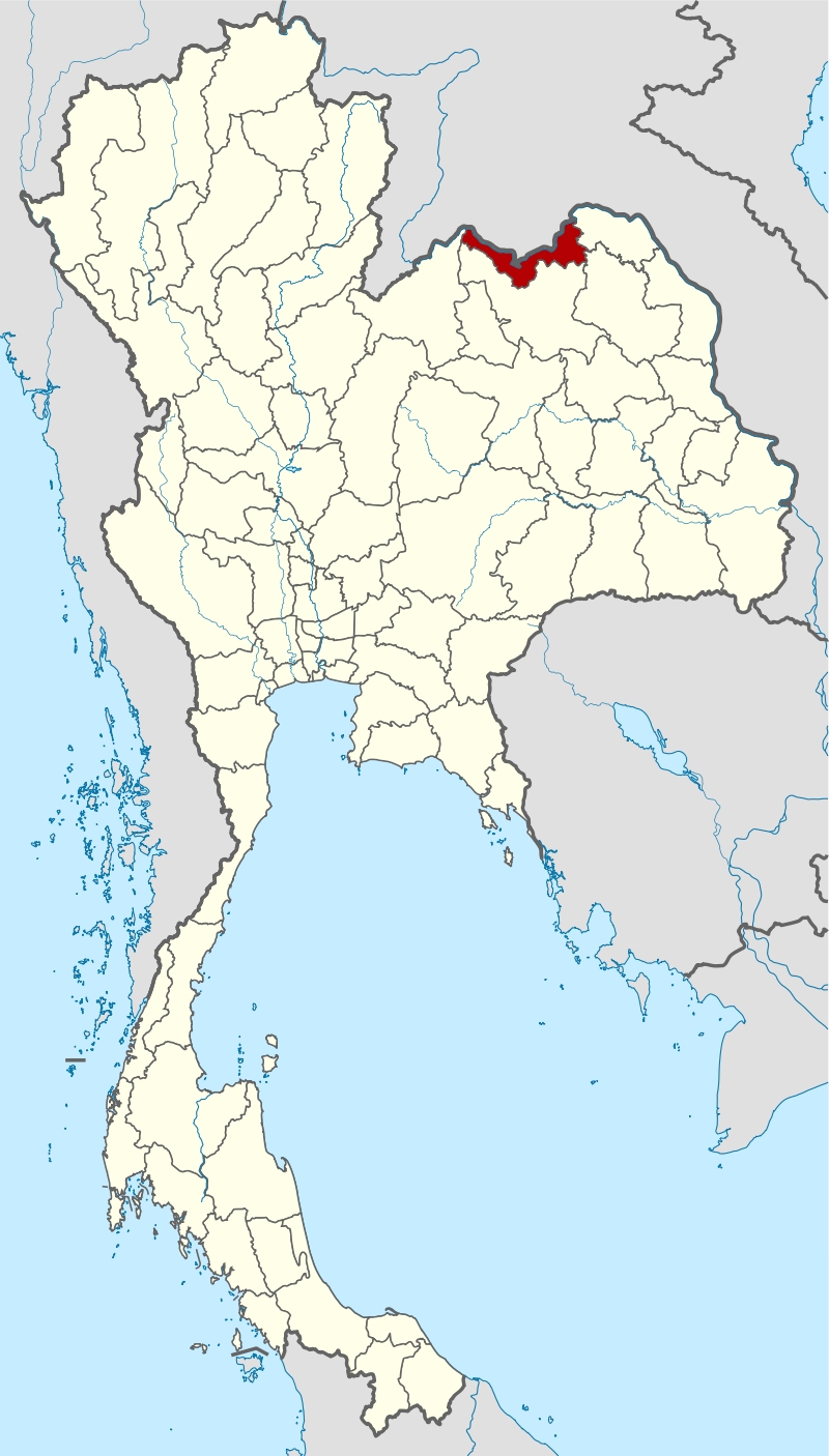
图片题注:廊开府位置图
图片作者:NordNordWest
| 国家 | |
|---|---|
| 首府 | 廊开 |
| 政府 | |
| • 府尹 | Rachan Soonhua (ราชันย์ ซุ้นหั้ว), since 2022(自2022起) |
| 面积 | |
| • 总计 | 3,275 km2 (1,264 sq mi) |
| 面积排名 | (第60名) |
| 人口(2019) | |
| • 总计 | 522,311人 |
| • 排名 | Ranked 52nd(第52名) |
| • 密度 | 160/km2 (400/sq mi) |
| • 密度排名 | Ranked 23rd(第23名) |
| Human Achievement Index[3](人类发展指数) | 0.5881 “average” Ranked 37th in 2017 0.5881“平均”,2017年,排名第37位 |
| 时区 | 泰国标准时间(UTC+7) |
| Postal code(邮政编码) | 43xxx |
| Calling code(电话区号) | 042 |
| ISO 3166码 | TH-43 |
2. 地理 | Geography
The province is in the valley of the Mae Nam Kong (Mekong River), which also forms the border with Laos. There are highlands to the south. The total forest area is 233 km2 (90 sq mi) or 7.1 percent of provincial area.[1] The Laotian capital, Vientiane, is only 25 kilometers (16 mi) from the provincial capital of Nong Khai. The First Thai–Lao Friendship Bridge, which connects the two countries, was built jointly by the governments of Thailand, Laos, and Australia, and was opened in 1994.[4]
参考译文:这个省份位于湄公河河谷,与老挝接壤。南部有高地。全省森林面积为233平方公里(90平方英里),占全省面积的7.1%。老挝首都万象距离该省首府廊开只有25公里(16英里)。连接两国的第一座泰老友谊桥由泰国、老挝和澳大利亚政府共同建造,于1994年通车。
Nong Khai is the smallest province in the northeastern after Bueng Kan and other seven districts became Bueng Kan province in 2011.
参考译文:廊开府是东北部最小的省份,在2011年,其东部的七个县成为孔敬府后。
- 面积约为7,332.3平方公里,距首都曼谷约为615公里。其疆域北濒老挝,以湄公河为界;南接乌隆府及沙功那空府;东连汶干府;西毗黎府。
- 廊开府的北部为治海低洼平原,东畔为高山间以丛林,西边为连绵不绝的山脉,一直延伸至黎府,南方为高原地带。该府三季气候非常明显 ,夏季可热至41.8摄氏度;冬季则冷至5.2摄氏度;雨季时则雨量特多。渔业发达。
2. 历史 | History
Main article: Haw wars(主条目:霍战争)
该府原名为“曼派村”,原属老挝的“万象城”统治。拉达那哥欣王国时代,该村及万象城被暹罗入侵占据,暹罗人于1827年建立起防御城池,命名为“廊开府”,并管辖“万象城”(今老挝万象)。直至1893年,暹罗才与法国按照中止纠纷协约,割去“万象城”给法国。
Over the centuries, control of the province swung between the Thai Kingdom Ayutthaya, and the Laotian kingdom Lan Xang, as their respective powers ebbed and flowed in the region.[5]
参考译文:几个世纪以来,该省的控制权在泰国大城府和老挝澜沧王国之间摇摆,随着各自势力在该地区的消长。 [5]
The Prap Ho Monument in front of the historic city hall (now a museum and cultural center) memorializes the war dead of the Haw wars.[6]
参考译文:历史悠久的市政厅(现为博物馆和文化中心)前的 Prap Ho 纪念碑纪念 Haw 战争中的阵亡将士。 [6]
In more recent years, Nong Khai has become a popular destination during the Buddhist Lent festival when mysterious balls of light, or Naga fireballs, rise from the Mekong River. The balls resemble an orange sun. They rise out of the river approximately 6–9 meters (20 to 30 feet) and disappear after three to five seconds. Although the fireballs can be seen at other times, most Thais travel to see them during the full moon in October when the incidence of them is considered to be much higher.[7]
参考译文:近年来,廊开府已成为佛教斋戒节期间的热门目的地,神秘的光球或那加火球从湄公河升起。这些球类似于橙色太阳。它们从河中升起约6-9米(20至30英尺),并在三到五秒后消失。虽然火球可以在其他时间看到,但大多数泰国人在10月份满月时前往观看,因为此时它们的发生率被认为要高得多。[7]
Nong Khai’s main sight is Sala Keoku (alternatively spelled as Sala Kaew Ku, also known as Wat Khaek), a park of colossal sculptures, some over 20 m tall. The park is the handiwork of the mystic Luang Pu Bunleua Sulilat, who bought the land in 1978 when he was exiled from his native Laos, where he had built a similar park in Vientiane in the 1950s. Synthesizing Buddhist and Hinduist ideologies, Buddhas, many-armed goddesses, a seven-headed Naga snake, and various human-animal hybrids dominate the site.[8]
参考译文:廊开府的主要景点是Sala Keoku(也拼写为Sala Kaew Ku,又称Wat Khaek),一个拥有巨大雕塑的公园,其中一些超过20米高。这个公园是由神秘的Luang Pu Bunleua Sulilat手工制作的,他在1978年被流放到他的祖国老挝时购买了这片土地,他在那里的万象市建立了一个类似的公园,在20世纪50年代。佛教和印度教的思想融合在一起,佛、多臂女神、七头那迦蛇和各种人兽混合体主宰着这个地方。[8]
Notable figures from twentieth century Buddhist history have lived in Nong Khai—the world renowned Buddhist scholar and leading meditation teacher Ajahn Sumedho ordained in Wat Sisaket in Nong Khai.
参考译文:二十世纪佛教历史上的著名人物曾在廊开居住过——世界著名的佛教学者和领先的冥想导师阿姜苏美多 (Ajahn Sumedho) 在廊开的 Wat Sisaket 出家。
3. 行政区域 | Administrative divisions
3.1 省政府 | Provincial government
廊开府原来分为17个县,该等县份辖下再分成共115个区和1,099条村。2011年3月23日,汶干县等8个东北部的县从廊开府独立,成为汶干府。廊开府只余下9个县,共62个区和705条村。

图片题注:Map of Nong Khai province, Thailand(泰国廊开府地图)
图片作者:Hdamm
| 图中编号 | 中文名 | 泰文名 | 英文名 |
| 1 | 廊开府治县 | เมืองหนองคาย | Mueang Nong Khai |
| 2 | 塔波县 | ท่าบ่อ | Tha Bo |
| 5 | 蓬披赛县 | โพนพิสัย | Phon Phisai |
| 7 | 西清迈县 | ศรีเชียงใหม่ | Si Chiang Mai |
| 8 | 桑空县 | สังคม | Sangkhom |
| 14 | 沙格莱县 | สระใคร | Sakhrai |
| 15 | 福莱县 | เฝ้าไร่ | Fao Rai |
| 16 | 拉达那瓦比县 | รัตนวาปี | Rattanawapi |
| 17 | 普达县 | โพธิ์ตาก | Pho Tak |
3.2 地方政府 | Local government
As of 26 November 2019 there are:[10] one Nong Khai Provincial Administration Organisation (ongkan borihan suan changwat) and 19 municipal (thesaban) areas in the province. Nong Khai and Tha Bo have town (thesaban mueang) status. Further 17 subdistrict municipalities (thesaban tambon). The non-municipal areas are administered by 48 Subdistrict Administrative Organisations – SAO (ongkan borihan suan tambon).[2]
参考译文:截至2019年11月26日,该省有:[10]一个廊开府级行政机构(ongkan borihan suan changwat)和19个市(thesaban)区。廊开和塔博具有城镇(thesaban mueang)地位。还有17个区级市(thesaban tambon)。非市区由48个区级行政机构- SAO(ongkan borihan suan tambon)管理。[2]
4. 名胜古迹
- 峦坡拍晒佛:位于廊开府直辖县的坡猜寺(วัดโพธิ์ชัย,Wat Pho Chai)里,为一坐禅金佛像,它是廊开府的镇府之宝,每年6月份均在此举行隆重的礼佛盛会和烟花盛会。
- 巴柯纪念碑(อนุสาวรีย์ปราบฮ่อ,Prap Ho Monument):位于府署前面,是纪念1886年为暹罗入侵老挝边境疆土而殉职的暹罗军人而建,碑文刻有中文、英文、老挝文及泰文等四种文字,每年3月5日均在此举行祭奠仪式。
- 拍它孟奔塔:位于廊开府直辖县,为印度式佛塔,内有29位高僧的舍利子,每年泰历二月份均举行礼佛盛会。
- 拍昭翁迪佛:位于他帽县的哇喃孔寺,它为廊开府的一尊重要大佛像,高4米,宽3.29米,始建于1562年。
- 探提瀑布(น้ำตกธารทิพย์,Namtok Than Thip):又名达什瀑布,位于讪空县的三层小瀑布,周边环境优美。
- 探汤瀑布(น้ำตกธารทอง,Namtok Than Thong):位于讪空县,类似探提瀑布,廊开府的民众喜欢前往休闲消遣。
- 哇欣玛炳寺(วัดหินหมากเป้ง,Wat Hin Mak Peng):位于是清迈县,是修禅学佛的幽静禅院,可欣赏“孔河”岸边的天然美景。
- 峦坡拍猜砌它佛(หลวงพ่อพระเจ้าองค์ตื้อ,Luangpho Phrachao Ong Tue):位于哇史明寺(Wat Si Chomphu Ong Tue),为一尊立姿佛像,深受民众崇拜。
- 蒲牛寺:为野生动物保护区,其间有砂石山、森林、草原、山洞、瀑布,景致优美。而华蒲山岭则是平面岩石区,可眺望老挝边境的山峦。
- 老挝-泰国友好大桥(สะพานมิตรภาพไทย-ลาว,Lao Thai Friendship Bridge):位于老挝与泰国边境的湄公河上,大桥全长约1,774米,于1994年4月8日正式启用。
5. 交通 | Transport
5.1 航空 | Air
The nearest airport is Udon Thani International Airport, 56 km from Nong Khai.
参考译文:最近的机场是乌隆他尼国际机场,距离Nong Khai有56公里。
5.2 铁路 | Rail
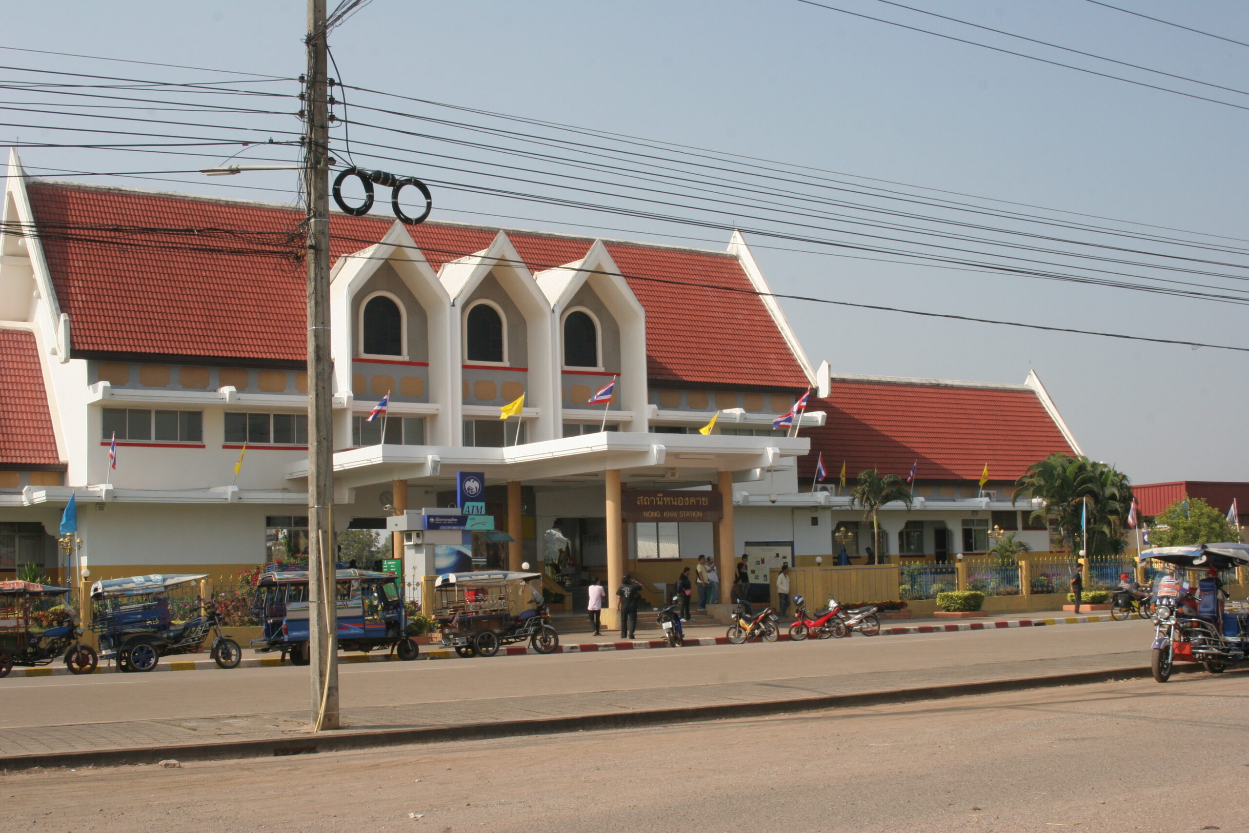
图片题注:Nong Khai railway station
图片作者:シャムネコ
The main railway station in Nong Khai is Nong Khai railway station. This station can be considered the destination of the Upper Northeastern Railway Line (only in Thailand’s area).
参考译文:廊开府的主要火车站是廊开火车站。 该站可以认为是上东北铁路线的终点站(仅限泰国地区)。
5.3 公路 | Road
The Thai–Lao Friendship Bridge was largely funded by a gift to the Lao government from the Australian government.[11] It is the road and railway gateway to Laos’s capital, Vientiane (25 kilometers (16 mi) upriver), on the north bank opposite the Thai town of Si Chiang Mai District. Construction of a rail spur to Thanaleng outside of Vientiane was begun early-2007 and officially opened 5 March 2009.[12]
参考译文:泰老友谊大桥主要由澳大利亚政府向老挝政府赠送的一笔资金资助。[11]它是通往老挝首都万象(上游25公里(16英里) )的道路和铁路门户,位于泰国小镇Si Chiang Mai District对面的北岸。2007年初开始建设万象城外的塔纳琅铁路支线,并于2009年3月5日正式开通。[12]
Nong Khai is 626 km north of Bangkok[13] and 60 km north of Udon Thani.[14]
参考译文:廊开位于曼谷以北 626 公里[13],乌隆他尼以北 60 公里处。[14]
6. 2017年人类发展指数 | Human achievement index 2017

The Human achievement index (HAI), a composite index covering eight key areas of human development, has been tracked by National Economic and Social Development Board (NESDB) since 2017.[3]
参考译文:人类成就指数(HAI)是涵盖人类发展八个关键领域的综合指数,自 2017 年以来一直由国家经济和社会发展委员会(NESDB)跟踪。 [3]
| Rank 分数 | Classification 分类 |
| 1 – 15 | “high” 高 |
| 16 – 30 | “somewhat high” 较高 |
| 31 – 45 | “average” 平均 |
| 45 – 60 | “somewhat low” 较低 |
| 61 – 77 | “low” 低 |
包含省份和 HAI 2017 排名的地图 | Map with provinces and HAI 2017 rankings
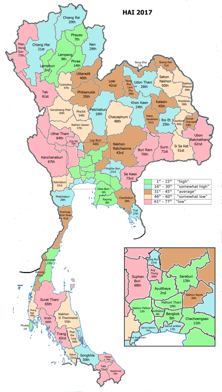
图片题注:Map with provinces of Thailand and HAI 2017 rankings
图片作者:SietsL
参考译文:泰国各省地图和 HAI 2017 排名
7. 参考文献 References
- · “ตารางที่ 2 พี้นที่ป่าไม้ แยกรายจังหวัด พ.ศ.2562” [Table 2 Forest area Separate province year 2019]. Royal Forest Department (in Thai). 2019. Retrieved 6 April 2021, information, Forest statistics Year 2019, Thailand boundary from Department of Provincial Administration in 2013
- · รายงานสถิติจำนวนประชากรและบ้านประจำปี พ.ส.2562 [Statistics, population and house statistics for the year 2019]. Registration Office Department of the Interior, Ministry of the Interior. stat.bora.dopa.go.th (in Thai). 31 December 2019. Retrieved 26 February 2020.
- · Human achievement index 2017 by National Economic and Social Development Board (NESDB), pages 1-40, maps 1-9, retrieved 14 September 2019, ISBN 978-974-9769-33-1
- · “Thai-Lao Friendship Bridge”. Tourism Authority of Thailand (TAT). Retrieved 22 May 2015.
- · “Nong Khai”. Tourism Authority of Thailand (TAT). Retrieved 22 May 2015.
- · “Prap Ho Monument”. Tourism Authority of Thailand (TAT). Archived from the original on 22 May 2015. Retrieved 22 May 2015.
- · “The Naga fireballs, Nong Khai”. Tourism Authority of Thailand (TAT). Archived from the original on 22 May 2015. Retrieved 22 May 2015.
- · “Sala Kaeo Ku or Wat Khaek”. Tourism Authority of Thailand (TAT). Archived from the original on 22 May 2015. Retrieved 22 May 2015.
- · Masure, Yves. “Nong Khai”. THAILEX Travel Encyclopedia. Retrieved 22 May 2015.
- · “Number of local government organizations by province”. dla.go.th. Department of Local Administration (DLA). 26 November 2019. Retrieved 10 December 2019. 69 Nong Khai: 1 PAO, 2 Town mun., 17 Subdistrict mun., 48 SAO.
- · Australian Govt Dept of Foreign Trade, Feb 9 2008, “Archived copy” (PDF). Archived from the original (PDF) on 2014-07-31. Retrieved 2014-11-11.,
- · Spooner, Andrew (2009-02-27). “First Train to Laos”. The Guardian. Retrieved 22 May 2015.
- · “Distance: Bangkok to Nong Khai”. Google Maps. Retrieved 22 May 2015.
- · “Distance: Udon Thani to Nong Khai”. Google Maps. Retrieved 22 May 2015.
8. 外部链接 External links
- Nong Khai travel guide from Wikivoyage(维基导游上的廊开旅行指南)
- Provincial website (in Thai)(省级网站(泰语))
- Nong Khai Travel Guide(廊开旅行指南)
分享到: