
中文词条原文链接(无法从中国内地访问):请点击这里访问
英文词条原文链接(无法从中国内地访问):请点击这里访问
本文基于英文词条的线索,并补充部分来自中文词条的内容(在二者冲突时,以更晚更新者为准)。辽观搬运时进行了必要的合规化处理,以使其能够在中国内地上传。部分文字采用汉语拼音方式代替,音节后的数字表示汉语拼音规则中的声调。
关于辽观的维基百科搬运计划,及其他已搬运的词条,请点击这里了解更多。维基百科(Wikipedia)是美国维基媒体基金会的互联网百科项目,其内容可能受到立场、信息来源等因素影响,请客观看待。正文内容不代表译者观点。
辽观提供的翻译仅供参考。文中可能包含无法从中国内地访问的链接。
辽观所搬运的词条文本与维基百科一道同样遵循CC BY-SA 4.0协议(辽观搬运的中英文对照版本),在符合协议要求的情况下您可以免费使用其内容(包括商用)。图片和视频可能遵循不同的共享协议。请点击这里访问
This article contains Lanna text. Without proper rendering support, you may see question marks, boxes, or other symbols instead of Tai Tham script.
【参考译文】本文包含兰纳文字。如果没有正确的渲染支持,您可能会看到问号、方框或其他符号,而不是Tai Tham字母。
目录
- 0. 概述
- 1. 地理 | Geography
- 2. 历史 | History
- 3. 人口统计 | Demographics
- 4. 标志 | Symbols
- 5. 行政区划和邮政编码 | Administrative divisions and postal codes
- 6. 2022年人类成就指数 | Human achievement index 2022
- 7. 交通 | Transportation
- 8. 旅游业 | Tourism
- 8. 卫生健康 | Health
- 9. 本地产品 | Local products
- 10. 本地文化 | Local culture
- 11. 图集 | Galleries
- 12. 友好城市 | Sister cities
- 13. 知名人物 | Notable inhabitants
- 参见、参考文献、外部链接
0. 概述
辽观注:此标题是我们在搬运、整合过程中添加的。
清迈府(泰语:จังหวัดเชียงใหม่,皇家转写:Changwat Chiang Mai,泰语发音:[t͡ɕāŋ.wàt t͡ɕʰīaŋ.màj];兰纳语:ᨩ᩠ᨿᨦᩉᩲ᩠ᨾ᩵,tɕiaŋ.màj),泰国北部边陲的一个府,北面与缅甸接壤。另外,清迈府与另外5个府为邻:清莱府(东北)、南邦府(东)、南奔府(东南)、达府(南)及夜丰颂府(西)。面积为20,107平方公里。府治为清迈市。
The capital, Chiang Mai, is 685 kilometres (426 mi) north of Bangkok.
【参考译文】省会清迈距离曼谷685公里(426英里)。
1. 地理 | Geography
清迈府位处泰北山区和滨河流域,连绵山脉呈南北走向。本府有泰国最高山峰因他暖山(海拔2,565米高,距府治清迈市西南偏西约40公里。昭披耶河的其中一条支流滨河(Mae Ping)源自该府,并流经清迈市顺流南下。清迈府有丰富的动植物资源、自然风光和名胜古迹。
Chiang Mai province is about 685 km (426 mi) from Bangkok in the Mae Ping River basin and is on average at 300 m (1,000 ft) elevation. Surrounded by the mountain ranges of the Thai highlands, it covers an area of approximately 22,135 km2 (9,000 sq mi). The mountains of the Daen Lao Range (ทิวเขาแดนลาว) at the north end of the province, the Thanon Thong Chai Range (เทือกเขาถนนธงชัย) with the highest mountain in Thailand, Doi Inthanon at 2,565 metres (8,415 ft), stretching in a north–south direction, and the Khun Tan Range in the east of the province are covered by rain forest. The Mae Ping, one of the major tributaries of the Chao Phraya River, originates in the Daen Lao mountains. Several national parks are in the province: Doi Inthanon,[6] Doi Suthep-Pui,[7] Ob Luang,[8] Sri Lanna,[9] Huai Nam Dang,[10] Mae Wang,[11] and Pha Daeng.[12] The total forest area is 15,404 km2 (5,948 sq mi) or 69.6 percent of provincial area.[2]
【参考译文】清迈省距离曼谷约685公里(426英里),位于湄平(滨)河流域,平均海拔约为300米(1,000英尺)。被泰国高地的山脉环绕,该省的面积大约为22,135平方公里(9,000平方英里)。省北部的岱劳山脉(ทิวเขาแดนลาว)、从北向南延伸的坦通猜山脉(เทือกเขาถนนธงชัย)——其中包含泰国最高峰茵他侬山,海拔2,565米(8,415英尺),以及省东部的坤坦山脉均覆盖着雨林。湄平河是昭披耶河的主要支流之一,发源于岱劳山脉。该省内有几个国家公园:茵他侬山国家公园[6]、茵他侬-普伊国家公园[7]、奥汗国家公园[8]、西兰娜国家公园[9]、怀南当国家公园[10]、湄汪国家公园[11]和Pha Daeng国家公园[12]。森林总面积为15,404平方公里(5,948平方英里),占全省面积的69.6%[2]。
| Nickname: Nakhonph【昵称】ai:นครพิงค์) | |
| Motto(s)【格言】: ดอยสุเทพเป็นศรี ประเพณีเป็นสง่า บุปผชาติล้วนงามตา นามล้ำค่านครพิงค์ (“Famed Doi Suthep. Elegant traditions. Beautiful blossoms. Invaluable name of Nakhonphing.”) 【(“著名的茵他侬山。优雅的传统。美丽的花朵。无可估量的北方之都的名字。”)】 | |
| Anthem【府歌】: นครเชียงใหม่ Nakhon Chaing Mai (De facto)【事实上的歌曲】 | |
Coordinates【经纬度位置】:  18°50′14″N 98°58′14″E 18°50′14″N 98°58′14″E | |
| Founded by【创立者】 | Mangrai【孟莱王】 |
|---|---|
| Capital【首府】 | Chiang Mai【清迈府】 |
| Government【政府】 | |
| • Governor【府尹】 | Nirat Pongsitthaworn (since October 2022【自2022年10月起】)[1] |
| Area[2]【面积】 | |
| • Total【总面积】 | 20,107 km2 (7,763 sq mi) |
| • Rank【在泰国排名】 | 2nd【第二名】 |
| Population (2022)[3]【人口(2022年)】 | |
| • Total【总人口】 | 1,792,474 |
| • Rank【在泰国排名】 | Ranked 4th【第四名】 |
| • Density【人口密度】 | 81/km2 (210/sq mi) |
| • Rank【在泰国排名】 | Ranked 63rd【第63名】 |
| Human Achievement Index[4]【人类成就指数】 | |
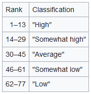
| • HAI (2022) | 0.6179 “low”【“低”】 Ranked 68th【在泰国排68名】 |
| GDP[5]【国内生产总值】 | |
| • Total【总值】 | baht 232 billion【2320亿泰铢】 (US$8.0 billion) (2019)【80亿美元(2019年)】 |
| Time zone【时区】 | UTC+7 (ICT)【东七区】 |
| Postal code【邮政编码】 | 50xxx |
| Calling code【电话区号】 | 052 & 053 |
| ISO 3166 code【国际标准国家地区 和行政区划代码】 | TH-50 |
| Vehicle registration【车牌号】 | เชียงใหม่ |
| Accession into Siam (Thailand) 【加入暹罗(今泰国)的时间】 | 1910 |
| Website【网站】 | chiangmai.go.th |

“Chiang Mai” in Thai language (top) and Northern Thai with Tai Tham script (bottom)
【”清迈”在泰语中的写法(上方)和北方泰语使用Tai Tham字母的写法(下方)】
1.1 国家公园 | National parks
There are fifteen national parks, making up region 16 of Thailand’s protected areas.
【参考译文】共有十五个国家公园,构成了泰国保护区域的第16区。
- Si Lanna National Park, 1,405 km2 (542 sq mi)[13]: 60
【参考译文】斯兰纳国家公园,1,405 平方公里(542 平方英里)[13]: 60 - Huai Nam Dang National Park, 1,252 km2 (483 sq mi)[13]: 81
【参考译文】怀南当国家公园,1,252 平方公里(483 平方英里)[13]: 81 - Pha Daeng National Park, 1,123 km2 (434 sq mi)[13]: 99
【参考译文】Pha Daeng 国家公园,1,123 平方公里(434 平方英里)[13]: 99 - Mae Ping National Park, 1,004 km2 (388 sq mi)[13]: 31
【参考译文】湄平(滨河)国家公园,1,004 平方公里(388 平方英里)[13]: 31 - Op Luang National Park, 553 km2 (214 sq mi)[13]: 68
【参考译文】Op Luang 国家公园,553 平方公里(214 平方英里)[13]: 68 - Doi Pha Hom Pok National Park, 524 km2 (202 sq mi)[13]: 97
【参考译文】Doi Pha Hom Pok 国家公园,524 平方公里(202 平方英里)[13]: 97 - Doi Inthanon National Park, 482 km2 (186 sq mi)[13]: 6
【参考译文】茵他侬国家公园,482 平方公里(186 平方英里)[13]: 6 - Mae Tho National Park, 433 km2 (167 sq mi)[14]: 3
【参考译文】湄索国家公园,433 平方公里(167 平方英里)[14]: 3 - Mae Takrai National Park, 354 km2 (137 sq mi)[13]: 131
【参考译文】Mae Takrai 国家公园,354 平方公里(137 平方英里)[13]: 131 - Doi Wiang Pha National Park, 303 km2 (117 sq mi)[14]: 13
【参考译文】Doi Wiang Pha 国家公园,303 平方公里(117 平方英里)[14]: 13 - Doi Suthep–Pui National Park, 257 km2 (99 sq mi)[13]: 24
【参考译文】素贴山-普伊国家公园,257 平方公里(99 平方英里)[13]: 24 - Op Khan National Park, 227 km2 (88 sq mi)[14]: 15
【参考译文】奥普汗国家公园,227 平方公里(88 平方英里)[14]: 15 - Khun Khan National Park, 208 km2 (80 sq mi)[13]: 126
【参考译文】坤汗国家公园,208 平方公里(80 平方英里)[13]: 126 - Mae Wang National Park, 119 km2 (46 sq mi)[13]: 112
【参考译文】湄旺国家公园,119 平方公里(46 平方英里)[13]: 112 - Namtok Bua Tong–Namphu Chet Si National Park, 86 km2 (33 sq mi)[14]: 9
【参考译文】Namtok Bua Tong–Namphu Chet Si 国家公园,86 平方公里(33 平方英里)[14]: 9
1.2 野生动物保护区 | Wildlife sanctuaries
There are four wildlife sanctuaries, make up region 16 of Thailand’s protected areas.
【参考译文】有四个野生动物保护区,构成泰国保护区的第 16 区。
- Omkoi Wildlife Sanctuary, 1,224 km2 (473 sq mi)[15]: 4
【参考译文】Omkoi 野生动物保护区,1,224 平方公里(473 平方英里)[15]: 4 - Chiang Dao Wildlife Sanctuary, 521 km2 (201 sq mi)[15]: 2
【参考译文】清佬野生动物保护区,521 平方公里(201 平方英里)[15]: 2 - Mae Lao–Mae Sae Wildlife Sanctuary, 514 km2 (198 sq mi)[15]: 5
【参考译文】Mae Lao-Mae Sae 野生动物保护区,514 平方公里(198 平方英里)[15]: 5 - Samoeng Wildlife Sanctuary, 194 km2 (75 sq mi)[15]: 3
【参考译文】萨蒙野生动物保护区,194 平方公里(75 平方英里)[15]: 3
1.3 气候 | Climate
Chiang Mai has a tropical wet and dry climate (Köppen Aw), tempered by the low latitude and moderate elevation, with warm to hot weather year-round, though nighttime conditions during the dry season can be cool and are much lower than daytime highs. The maximum temperature ever recorded is 42.4 °C (108.3 °F) in May 2005.[16]
【参考译文】清迈拥有热带干湿季气候(柯本气候分类法下的Aw类型),由于低纬度和适度的海拔高度,全年天气温暖至炎热,但在旱季夜间温度可以变得凉爽,并且比白天的高温要低得多。有记录以来的最高气温是在2005年5月达到的42.4°C(108.3°F)。[16]
2. 历史 | History
Main articles: Kingdom of Chiang Mai and Lan Na Kingdom【主条目:清迈王国 和 兰纳王国】
1274年(至元十一年),元朝设置云南等处行中书省,清迈属于云南等处行中书省所管辖。
1292年,傣阮族人庸那伽国王孟莱王(พญาเม็งราย,Phaya Mengrai)于清迈城建立兰纳王国。
The city of Chiang Mai, the capital of Chiang Mai province, was also capital of the Lanna Kingdom after its founding in 1296, during the same period of time as the establishment of the Sukhothai Kingdom.[17] From then, Chiang Mai not only became the capital and cultural core of the Lanna Kingdom, but also the centre of Buddhism in northern Thailand. King Meng Rai built many temples in the region.
【参考译文】清迈市,作为清迈省的首府,在1296年建立后也成为了兰纳王国的首都,这一时期正好与素可泰王国的建立同期。从那时起,清迈不仅成为了兰纳王国的政治和文化中心,也是泰国北部佛教的中心。孟莱王在该地区建造了许多寺庙。
1599年,阿瑜陀耶王国占领了这里。
In 1558, Chiang Mai became a colony of the First Toungoo Empire. Chiang Mai remained its colony for more than 200 years, until the Burmese–Siamese War (1775–1776). In 1774 the Burmese colonial regime were finally driven out of Chiang Mai by a coalition of Lanna and Siamese forces and it then became a tributary state of Siam, which later installed a Lanna chieftain ally, Kawila, to independently rule over Lampang and Chiang Mai region as a monarch.
【参考译文】1558年,清迈成为第一个东吁帝国的殖民地。清迈作为其殖民地持续了超过200年,直到1775年至1776年的缅暹战争。1774年,兰纳和暹罗联军最终将缅甸殖民统治者驱逐出清迈,并使其成为暹罗的附属国。随后,暹罗立了一位兰纳盟友酋长卡威拉为君主,独立统治喃邦和清迈地区。
In the reign of King Rama V of Siam, under his administrative centralization policy and due to the ineptitude of Chiang Mai’s ruling family, Chiang Mai eventually lost its independence, was annexed and became a second level subdivision of Siam.[citation needed]
【参考译文】在暹罗国王拉玛五世统治期间,由于中央集权政策的实施以及清迈统治家族的无能,清迈最终失去了独立地位,被暹罗吞并并成为其二级行政区划。[需要引证]
From 1933 on, Chiang Mai received its status as a “province” of Siam and has remained so until the present day.[citation needed]
【参考译文】从1933年起,清迈获得了暹罗“省份”的地位,并一直保持至今。[需要引证]
3. 人口统计 | Demographics
截至2005年清迈府人口为1,649,457人。
Of the population, 13.4 percent in the province are members of hill tribes:
【参考译文】在清迈省的人口中,有13.4%属于山区民族:
- Akha the largest population of any hill tribe in the region. Originating from Tibet and Southern China, they dwell on high ground around 1,200 metres (3,937 ft) above sea-level. Within their villages they build a spirit gateway to protect them from evil spirits.
【参考译文】阿卡族(Akha)是该地区最大的山区民族群体。他们源自西藏和中国南部,居住在海拔约1,200米(3,937英尺)的高地上。在他们的村落中,他们会建造精神门户来保护自己免受邪灵侵扰。 - Hmong from southern China. Prefer higher elevations. They raise livestock and grow rice, corn, tobacco, and cabbage. Known for their embroidery and silver.
【参考译文】苗族(Hmong)来自中国南部。他们更倾向于居住在更高的海拔上。苗族饲养牲畜,种植水稻、玉米、烟草和卷心菜。他们以刺绣和银饰闻名。 - Karen occupy valleys and riverbanks.
【参考译文】卡伦族(Karen)占据山谷和平原地带。 - Lahu from southern China and live in high areas. They are known as hunters and planters.
【参考译文】拉祜族(Lahu)来自中国南部,生活在高海拔地区。他们以狩猎和种植著称。 - Lisu from southern China and Tibet are renowned for their colorful dress and also build their dwellings on high poles. They harvest rice and corn and their men are skilled in hunting.
【参考译文】利苏族(Lisu)来自中国南部和西藏,以其多彩的服饰而闻名,同时也会将住所建在高高的柱子上。他们种植水稻和玉米,男性擅长狩猎。 - Tai Lue live in dwellings of usually only a single room wooden house built on high poles. They are skilled in weaving.
【参考译文】德昂族(Tai Lue)通常住在只有一间房间的木屋中,这些木屋建在高高的柱子上。他们擅长编织。 - Tai Yai, Burmese in origin, harvest rice, farm, raise cattle and trade. Their craftsmanship lies in weaving, pottery, wood carving and bronze ware.
【参考译文】大尾族(Tai Yai),源于缅甸,种植水稻、从事农业、养殖牛群并进行贸易。他们的手工艺包括编织、陶器、木雕和青铜制品。 - Yao reside on mountainsides and grow corn and other crops. They are skilled blacksmiths, silversmiths and embroiders.
【参考译文】瑶族(Yao)居住在山坡上,种植玉米和其他作物。他们是出色的铁匠、银匠和刺绣师。
4. 标志 | Symbols
The seal of the province shows a white elephant in a glass pavilion. The white elephant is a royal symbol in Thailand, and it is depicted to remember the offering of a white elephant by Thammalangka, a ruler of Chiang Mai, to his overlord, King Rama II of Bangkok. The pavilion symbolizes that Buddhism prospered in Chiang Mai, especially when in 1477 the teachings of Buddha, the Tripitaka, were reviewed.[18]
【参考译文】省徽上展示的是一座玻璃亭中的白象。白象在泰国是皇家的象征,这个图案是为了纪念清迈的统治者Thammalangka向他的宗主、曼谷的拉玛二世国王进贡白象的事迹。亭子象征着佛教在清迈繁荣昌盛,特别是在1477年,佛教教义《三藏》在此地进行了审查。[18]
The provincial flower and tree is the “flame of the forest” (Butea monosperma).[18]
【参考译文】省花和省树是“森林之火”(Butea monosperma)。[18]
The provincial slogan is In the shadow of Mount Doi Suthep, blessed with rice customs and traditions, beautiful wild flowers, magnificent Nakhon Phing.[18]
【参考译文】省级口号是:“茵他侬山的阴影下,享有稻作习俗和传统,美丽的野花,宏伟的北方之都。”[18]
5. 行政区划和邮政编码 | Administrative divisions and postal codes
清迈府共分为24县(Amphoe);再分成共204区(Tambon);并再细分成1,915村(Muban)。
5.1 行政区划
辽观注:此标题是我们在搬运、整合过程中添加的。
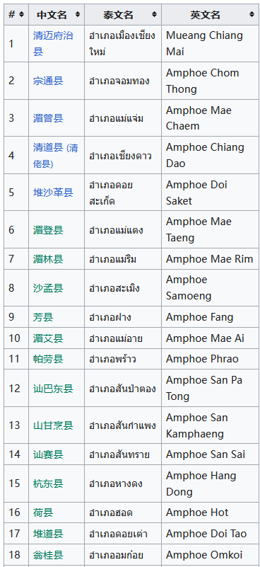
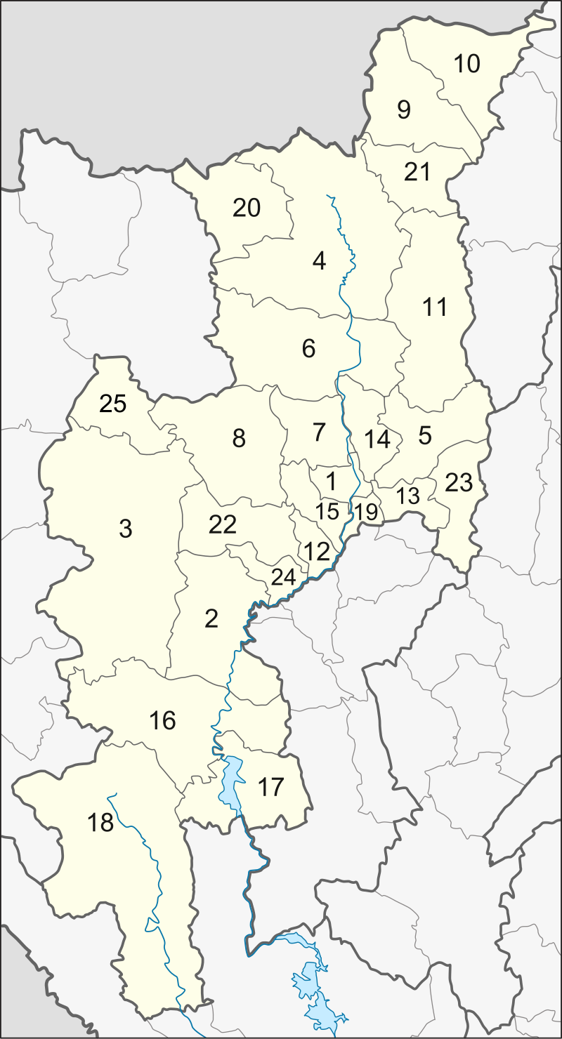
图片作者:Hdamm
此图片标号与上表和下文对应。
5.2 邮政编码
- Mueang Chiang Mai: 50000
- Chom Thong: 50160
- Mae Chaem: 50270
- Chiang Dao: 50170
- Doi Saket: 50220
- Mae Taeng: 50150
- Mae Rim: 50180
- Samoeng: 50250
- Fang: 50110
- Mae Ai: 50280
- Phrao: 50190
- San Pa Tong: 50120
- San Kamphaeng: 50130
- San Sai: 50210
- Hang Dong: 50230
- Hot: 50240
- Doi Tao: 50260
- Omkoi: 50310
- Saraphi: 50140
- Wiang Haeng: 50350
- Chai Prakan: 50320
- Mae Wang: 50360
- Mae On: 50130
- Doi Lo: 50160
- Galyani Vadhana: 50270[19]
5.3 地方政府 | Local government
As of 26 November 2019 there are:[20] one Chiang Mai Provincial Administration Organisation (ongkan borihan suan changwat) and 121 municipal (thesaban) areas in the province. Chiang Mai has city (thesaban nakhon) status. Mae Jo, Mae Hia, Mueang Kaen Phatthana and Ton Pao have town (thesaban mueang) status. Further 116 subdistrict municipalities (thesaban tambon). The non-municipal areas are administered by 89 Subdistrict Administrative Organisations – SAO (ongkan borihan suan tambon).[3]
【参考译文】截至2019年11月26日,该省有:[20] 一个清迈省级行政组织(ongkan borihan suan changwat)和121个市政区域(thesaban)。清迈拥有城市(thesaban nakhon)地位。湄焦、湄希亚、美光帕塔纳和桐包具有镇(thesaban mueang)地位。此外还有116个次级区市政(thesaban tambon)。非市政区域由89个次级区行政组织(SAO,ongkan borihan suan tambon)管理。[3]
6. 2022年人类成就指数 | Human achievement index 2022
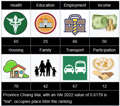
Since 2003, the United Nations Development Programme (UNDP) in Thailand has tracked progress on human development at sub-national level using the Human achievement index (HAI), a composite index covering all the eight key areas of human development. The National Economic and Social Development Board (NESDB) took over this task in 2017.[4]
【参考译文】自2003年以来,联合国开发计划署(UNDP)在泰国通过人类成就指数(HAI)跟踪了省级层面的人类发展进展,这是一个涵盖人类发展的八个关键领域的综合指数。2017年,国家经济和社会发展委员会(NESDB)接手了这项任务。[4]
7. 交通 | Transportation
- Road: Chiang Mai is on Highway 11, the only 2-digit road number in the province. Other roads connect the city of Chiang Mai with the north and south of the province, as well as with the east towards Chiang Rai province.
【参考译文】公路:清迈位于11号公路上,这是该省内唯一的两位数公路编号。其他道路连接清迈市与省内的北部和南部,以及向东通往清莱省。 - Train: Chiang Mai railway station is the northern terminus of the Northern Line, operated by the State Railway of Thailand.
【参考译文】火车:清迈火车站是泰国国家铁路运营的北部线的终点站。 - Air: Chiang Mai International Airport (CNX) is one of the seven Thai international airports under the aegis of the Airports of Thailand Public Company Limited (AOT).[21] As Chiang Mai International Airport is the major gateway to northern Thailand, it plays an important role in promoting travel and tourism throughout the northern region. Today, 14 airlines serve the airport and more than 3,000,000 passengers, 15,000 flights, and 16,000 tons of cargo are handled annually.[citation needed]*
【参考译文】航空:清迈国际机场(CNX)是泰国机场公共有限公司(AOT)管辖下的七个国际机场之一。作为通往泰国北部的主要门户,清迈国际机场对于促进整个北部地区的旅游和旅行发挥着重要作用。目前,14家航空公司服务该机场,每年处理超过300万名乘客、15,000架次航班和16,000吨货物。[需要引证]
8. 旅游业 | Tourism
Chiang Mai province is the tourist hub of the north and one of Thailand’s most important tourist destinations.[citation needed] It is considered one of the most scenic provinces in the country due to its mountain ranges, valleys, flora, and fauna. For example, the Hang Dong Canyon is coveted as a great tourist attraction. Furthermore, unlike most of Thailand, in some months, the climate in the north and Chiang Mai is cool, fresh, and misty.
【参考译文】清迈省是泰国北部的旅游中心,也是泰国最重要的旅游目的地之一。由于其山脉、山谷、丰富的植被和动物种类,它被认为是泰国风景最优美的省份之一。例如,杭东峡谷被视为一个极佳的旅游景点。此外,与泰国大部分地区不同的是,在某些月份,北部和清迈的气候凉爽、清新且多雾。
- 班达歪木雕村(Bantawai Village)——位于清迈古城西南方约25公里。是一处全村几乎都在从事木材雕刻的小村庄。那些木雕塑成为泰北地区特产之一。
- 博桑(Borsang)——位于清迈以东的讪甘烹县内的博桑村,是泰国北部最著名的清迈伞制作中心。博桑村民逐渐发展出自己特有的制伞技术,传统的清迈纸伞和棉布伞甚受游客欢迎,已成为当地农民农闲之暇,增添收入的来源。
- 湄沙(Maesa)——位于清迈市以西的Mae Rim区,较多自然风景区。还分别有训练大象和水牛这两种泰北重要的动物的学校、Sainanping兰花园等。
- 诗丽吉王后植物花园(Queen Sirkit Bontanic Garden)——位于清迈市西北27公里的山区内,是泰国第一所具国际水准的植物园,建立于1993年,目的在保护泰国特有的植物生态,为植物学研究的基地,占地960公顷的高科技植物园内,拥有8个玻璃温室及4个大型展示场地。展示内容包括自然科学、泰国兰花培育、泰国植物、药草品种、石头花园等。诗丽吉王后植物花园是泰国政府在1980年代决定发展泰北地区时,因为泰国王后诗丽吉王后对泰北人文发展甚为关注,所以特别设立这所具研究发展的院所。
- Doi Suthep-Pui国家公园和湄沙瀑布——1962年泰王普密蓬·阿杜德伉俪曾经到瀑布区游览,此后便开发成为泰国王室在泰北接待贵宾游览的主要景点。目前瀑布风景区的范围约50平方公里,由10个瀑布所组成。
8. 卫生健康 | Health
Each amphoe of Chiang Mai has its own hospital, but among the largest are located in Mueang Chiang Mai District and include Maharaj Nakorn Chiang Mai Hospital and Nakornping Hospital.
【参考译文】清迈每个县都有自己的医院,但其中最大的几家医院位于清迈直辖县,包括玛哈拉贾纳空清迈医院(Maharaj Nakorn Chiang Mai Hospital)和纳空平医院(Nakornping Hospital)。
9. 本地产品 | Local products
Chiang Mai is a handicrafts centre, with a variety of antiques, silver jewellery, and embroidery, Thai silks and cottons, basketry, celadon, silverware, furniture, lacquerware, woodcarvings, and parasols.[22]
【参考译文】清迈是一个手工艺品中心,拥有各种古董、银饰、刺绣、泰国丝绸和棉织品、竹编、青瓷、银器、家具、漆器、木雕和阳伞等。[22]
10. 本地文化 | Local culture
The north of Thailand’s culture is Lanna in origin and the people are proud of their northern roots. The region is home to distinctive foods, music, arts, way of life, and even language. Chiang Mai is home to various hill tribes and their own distinctive cultures.
【参考译文】泰国北部的文化源自兰纳,当地人民对自己的北部根源感到自豪。这一地区拥有独特的食物、音乐、艺术、生活方式,甚至语言。清迈是多个山区民族的家园,这些民族拥有各自独特文化。
10.1 本地食品 | Local food
See also: Thai cuisine【参见:泰国美食】
- Nam phrik ong is a type of Nam phrik chili paste which is made of minced pork and tomatoes. It is usually eaten with soft-boiled vegetables, pork crackling, or deep-fried crunchy rice cakes.
【参考译文】Nam phrik ong 是一种Nam phrik辣椒酱,由碎猪肉和番茄制成。通常搭配软煮蔬菜、猪肉脆皮或油炸酥脆米饼食用。 - Nam phrik num meaning “chili paste young man”, is another kind of paste which can be eaten with pork crackling.
【参考译文】Nam phrik num,意为“年轻男子的辣椒酱”,是另一种可以搭配猪肉脆皮食用的酱料。 - Sai ua is a local sausage that is very aromatic and spicy and is usually eaten with sticky rice.
【参考译文】Sai ua 是一种非常香辣的地方香肠,通常与糯米饭一起食用。 - Kaeng meaning “curry”, is not made with coconut milk in the north.
【参考译文】Kaeng,意为“咖喱”,在北方不使用椰奶制作。- Kaeng hang-le is northern-style pork curry
【参考译文】Kaeng hang-le 是北方风味的猪肉咖喱 - Kaeng om is a spicy curry consisting of intestines
【参考译文】Kaeng om 是一种辛辣咖喱,主要成分是内脏 - Kaeng khae is a spicy curry consisting mainly of vegetables.
【参考译文】Kaeng khae 是一种辛辣咖喱,主要由蔬菜组成。
- Kaeng hang-le is northern-style pork curry
- Khanom chin nam ngiao is a traditional northern noodle dish with chicken or pork.
【参考译文】Khanom chin nam ngiao 是一种传统的北方面条菜肴,以鸡肉或猪肉为主。 - Khao soi is a noodle dish which can be made from chicken, pork, or beef made with coconut milk and garnished with chopped fresh shallots, pickled cabbage, chilli paste to taste, and a slice of fresh lime.
【参考译文】Khao soi 是一种面条菜肴,可以用鸡肉、猪肉或牛肉制作,加入椰奶,并配以新鲜葱头、腌制白菜、根据口味添加的辣椒酱和一片新鲜青柠。
10.2 体育运动 | Sports
There are two main sport stadia in Chiang Mai and its environs: 700th Anniversary Stadium and Province Stadium. 700th Anniversary Stadium is on Klongchonpratan Road, 7 km (4.3 mi) from Chiang Mai University. There are swimming pools, diving pool, basketball arena, and 11 tennis courts.
【参考译文】清迈及其周边地区有两个主要的体育场馆:700周年体育场和省体育场。700周年体育场位于Klongchonpratan路,距离清迈大学7公里(4.3英里)。场内设有游泳池、跳水池、篮球场和11个网球场。
11. 图集 | Galleries
12. 友好城市 | Sister cities
The province is twinned with eight provinces/states.[23]
【参考译文】该省与八个省/州结为友好省/州关系。[23]
- Shanghai, China (2000)【中国上海(2000年)】
- Yogyakarta, Indonesia (2007)【印度尼西亚日惹(2007年)】
- Qingdao, China (2008)【中国青岛(2008年)】
- Chongqing, China (2008)【中国重庆(2008年)】
- Hokkaido, Japan (2013)[24]【日本北海道(2013年)[24]】
- Bursa, Turkey (2013)【土耳其布尔萨(2013年)】
- Chiang Tung, Myanmar (2014)[25]【缅甸掸邦(2014年)[25]】
- Chengdu, China (2015)【中国成都(2015年)】
13. 知名人物 | Notable inhabitants
- Thaksin Shinawatra (Thai: ทักษิณ ชินวัตร) (born 1949), politician and businessman
【参考译文】他信·西那瓦(丘达新)(1949年出生),政治家和商人 - Yingluck Shinawatra (Thai: ยิ่งลักษณ์ ชินวัตร) (born 1967), politician
【参考译文】英拉·西那瓦(丘英乐) (1967年出生),政治家
分享到: