

原文链接(无法从中国内地访问):https://en.wikipedia.org/wiki/Exclusive_economic_zone
辽观提供的译文仅供参考。原文和译文均遵守CC-BY-SA 4.0国际协议,在标注来源并遵守协议的情况下,您可以免费使用文章和图片内容,包括商用。
请注意:文中超链接可能导向中国内地无法访问的页面(如维基百科站内链接)。
封面图片:The world’s exclusive economic zones by boundary types and EEZ types(世界专属经济区的边界类型和EEZ类型)
提供者:Dr. Jean-Paul Rodrigue
Not to be confused with Special economic zone.
不要与经济特区混淆。
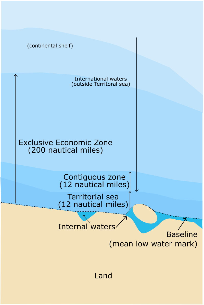
An exclusive economic zone (EEZ), as prescribed by the 1982 United Nations Convention on the Law of the Sea, is an area of the sea in which a sovereign state has special rights regarding the exploration and use of marine resources, including energy production from water and wind.[1] It stretches from the outer limit of the territorial sea (12 nautical miles from the baseline) out to 200 nautical miles (nmi) from the coast of the state in question. It is also referred to as a maritime continental margin and, in colloquial usage, may include the continental shelf. The term does not include either the territorial sea or the continental shelf beyond the 200 nautical mile limit. The difference between the territorial sea and the exclusive economic zone is that the first confers full sovereignty over the waters, whereas the second is merely a “sovereign right” which refers to the coastal state’s rights below the surface of the sea. The surface waters are international waters.[2]
根据1982年联合国海洋法公约规定,专属经济区(EEZ)是一个国家在海上具有特殊权利的区域,包括对海洋资源的勘探和利用权,包括水能和风能的能源生产[1]。它从领海的外限(基线起算,即距海岸线12海里)延伸到该国海岸线外的200海里(nmi)。它也被称为海上大陆边缘,在口语中可能包括大陆架。该术语不包括领海或超出200海里限制的大陆架。领海和专属经济区的区别在于前者赋予对水域的完全主权,而后者仅是指沿海国家在海洋表面以下拥有的“主权权利”。海面上的水属于国际水域[2]。
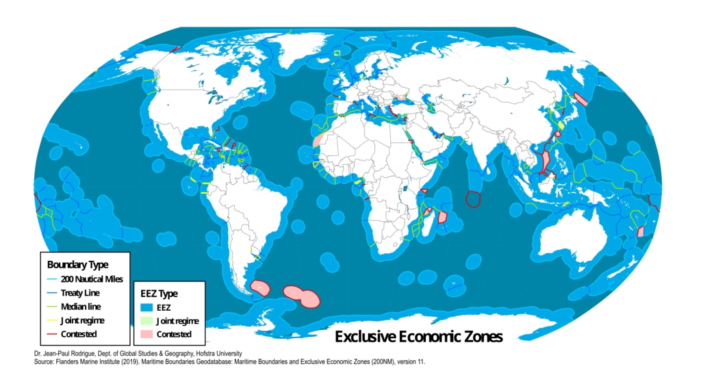
按边界类型和专属经济区类型划分的世界专属经济区
图片来源:Dr. Jean-Paul Rodrigue – SVG file given by Dr. Jean-Paul Rodrigue, converted to png with InkScape. Almost identical: https://transportgeography.org/wp-content/uploads/Map_Exclusive-Economic-Zones.pdf
目录
- 1. Definition 定义
- 2. Origin and history 起源和历史
- 3. Disputes 争议
- 4. Transboundary stocks 跨境资源
- 5. By country 各国专属经济区
- 5.1 Various island countries 多岛屿国家
- 5.2 Algeria 阿尔及利亚
- 5.3 Argentina 阿根廷
- 5.4 Australia 澳大利亚
- 5.5 Brazil 巴西
- 5.6 Canada 加拿大
- 5.7 Chile 智利
- 5.8 China 中国
- 5.9 Croatia 克罗地亚
- 5.10 Cyprus 塞浦路斯
- 5.11 Denmark 丹麦
- 5.12 Ecuador 厄瓜多尔
- 5.13 France 法国
- 5.14 Germany 德国
- 5.15 Greece 希腊
- 5.16 India 印度
- 5.17 Indonesia 印度尼西亚
- 5.18 Ireland 爱尔兰
- 5.19 Israel 以色列
- 5.20 Italy 意大利
- 5.21 Japan 日本
- 5.22 Malaysia 马来西亚
- 5.23 Mexico 墨西哥
- 5.24 New Zealand 新西兰
- 5.25 North Korea 朝鲜(北朝鲜)
- 5.26 Norway 挪威
- 5.27 Pakistan 巴基斯坦
- 5.28 Peru 秘鲁
- 5.29 Philippines 菲律宾
- 5.30 Poland 波兰
- 5.31 Portugal 葡萄牙
- 5.32 Romania 罗马尼亚
- 5.33 Russia 俄罗斯
- 5.34 Senegal 塞内加尔
- 5.35 Somalia 索马里
- 5.36 South Africa
- 5.37 South Korea 韩国(南朝鲜)
- 5.38 Spain 西班牙
- 5.39 Thailand 泰国
- 5.40 Turkey 土耳其
- 5.41 United Kingdom 英国
- 5.42 United States 美国
- 5.43 Vietnam 越南
- 6. Rankings by area 面积排名
- 参见 See also
- Notes 注释
- References 参考文献
- External links 外部链接
1. Definition 定义
国际权利海域(自上而下视图)
图片来源:historicair 16:23, 22 April 2006 (UTC) – Adapted from Image:Zones maritimes UNCLOS.jpg by an anonymous user
Generally, a state’s exclusive economic zone is an area beyond and adjacent to the territorial sea, extending seaward to a distance of no more than 200 nmi (370 km) out from its coastal baseline.[3] The exception to this rule occurs when exclusive economic zones would overlap; that is, state coastal baselines are less than 400 nmi (740 km) apart. When an overlap occurs, it is up to the states to delineate the actual maritime boundary.[4] Generally, any point within an overlapping area defaults to the nearest state.[5]
通常情况下,一个国家的专属经济区是指在领海之外且毗邻领海的区域,向海洋延伸的距离不超过200海里(370公里),以沿海基线为界限[3]。然而,当专属经济区发生重叠时,即沿海基线相距不到400海里(740公里)时,这个规则会有例外。当发生重叠时,各国需要划定实际的海上边界[4]。通常情况下,重叠区域内的任何一点归属于距离最近的国家[5]。
A state’s exclusive economic zone starts at the seaward edge of its territorial sea and extends outward to a distance of 200 nmi (370 km) from the baseline. The exclusive economic zone stretches much further into sea than the territorial waters, which end at 12 nmi (22 km) from the coastal baseline (if following the rules set out in the United Nations Convention on the Law of the Sea).[6] Thus, the exclusive economic zones includes the contiguous zone. States also have rights to the seabed of what is called the continental shelf up to 350 nmi (650 km) from the coastal baseline, beyond the exclusive economic zones, but such areas are not part of their exclusive economic zones. The legal definition of the continental shelf does not directly correspond to the geological meaning of the term, as it also includes the continental rise and slope, and the entire seabed within the exclusive economic zone.
一个国家的专属经济区从其领海的海上边界开始,向外延伸到距离基线200海里(370公里)的距离。专属经济区比领海更远,领海的边界在距离沿海基线12海里(22公里)的地方结束(如果遵循《联合国海洋法公约》的规定)[6]。因此,专属经济区包括了毗连区。国家对所谓的大陆架也有权利,大陆架从沿海基线向外延伸到距离350海里(650公里)的地方,超出了专属经济区,但这些区域不属于其专属经济区。大陆架的法律定义并不直接对应地质学上的含义,因为它还包括了大陆斜坡和大陆坡,以及专属经济区内的整个海底。
2. Origin and history 起源和历史
The idea of allotting nations’ EEZs to give them more control of maritime affairs outside territorial limits gained acceptance in the late 20th century.
将专属经济区分配给各国,以使它们在领土范围之外对海上事务拥有更多控制权的想法在20世纪末获得了认可。
Initially, a country’s sovereign territorial waters extended 3 nmi or 5.6 km (range of cannon shot) beyond the shore. In modern times, a country’s sovereign territorial waters extend to 12 nmi (22 km) beyond the shore. One of the first assertions of exclusive jurisdiction beyond the traditional territorial seas was made by the United States in the Truman Proclamation of 28 September 1945. However, it was Chile and Peru respectively that first claimed maritime zones of 200 nautical miles with the Presidential Declaration Concerning Continental Shelf of 23 June 1947 (El Mercurio, Santiago de Chile, 29 June 1947) and Presidential Decree No. 781 of 1 August 1947 (El Peruano: Diario Oficial. Vol. 107, No. 1983, 11 August 1947).[7]
最初,一个国家的主权领海延伸到岸边以外的3海里或5.6公里(大炮射程)。在现代,一个国家的主权领海延伸到岸边以外的12海里(22公里)。关于超出传统领海的专属管辖权的最早主张是由美国在1945年9月28日的杜鲁门宣言中提出的。然而,智利和秘鲁分别是在1947年6月23日的总统关于大陆架的宣言和1947年8月1日的总统第781号法令中首先宣称了200海里的海上区域(El Mercurio, Santiago de Chile, 29 June 1947和El Peruano: Diario Oficial. Vol. 107, No. 1983, 11 August 1947)[7]。
It was not until 1982 with the UN Convention on the Law of the Sea that the 200 nautical mile exclusive economic zone was formally adopted.
直到1982年《联合国海洋法公约》的通过,200海里的专属经济区才正式被采纳。
3. Disputes 争议
(英文维基百科的官方提示)
This section needs to be updated. Please help update this article to reflect recent events or newly available information. (June 2020)
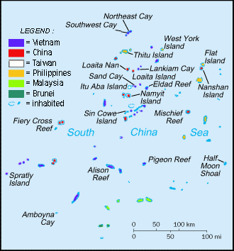
De facto territories in the Spratly Islands
南沙群岛事实上的领土
图片作者:Spiridon Manoliu – Cartothèque Spiridon Manoliu
The exact extent of exclusive economic zones is a common source of conflicts between states over marine waters.
专属经济区的确切范围是国家之间海域冲突的常见根源。
- The South China Sea is the setting for several ongoing disputes between regional powers including China, Taiwan, Vietnam, the Philippines, Indonesia, and Malaysia.
南海是中国、台湾、越南、菲律宾、印度尼西亚和马来西亚等地区大国之间持续存在的几项争端的所在地。 - Croatia’s ZERP (Ecological and Fisheries Protection Zone) in the Adriatic Sea caused friction with Italy and Slovenia, and caused problems during the accession of Croatia to the European Union.
克罗地亚在亚得里亚海设立的ZERP(生态和渔业保护区)引发了与意大利和斯洛文尼亚的摩擦,并在克罗地亚加入欧盟的过程中引起了问题。 - A wedge-shaped section of the Beaufort Sea is disputed between Canada and the United States, as the area reportedly contains substantial oil reserves.
波弗特海的楔形部分在加拿大和美国之间存在争议,因为据报道该地区蕴藏着大量石油储量。 - Mauritius claims an EEZ for Tromelin Island from France and an EEZ in respect of the British Indian Ocean Territory from the UK. An Exclusive Economic Zone covering 2.3 million square kilometres is claimed by Mauritius.
毛里求斯向法国主张特罗姆林岛专属经济区,并向英国主张英属印度洋领土专属经济区。 毛里求斯声称拥有面积230万平方公里的专属经济区。 - Turkey claims a portion of Cyprus’s claimed EEZ based on Turkey’s definition that no islands, including Cyprus, can have a full EEZ[8][9] and should only be entitled to 12 nautical miles. Furthermore, the internationally unrecognized Turkish Republic of Northern Cyprus (TRNC) also claims portions of Cyprus’s claimed EEZ. Cyprus, intergovernmental organizations, and other territories, such as the European Union, United States, Russia, Israel, Switzerland, Egypt, and Saudi Arabia do not acknowledge the Turkish claims[10][11][12][13][14] on Cyprus’s land and claimed sea, and urge Turkey to restrain itself from “illegal” drilling for gas in the island’s claimed EEZ.[a] The EU has threatened Turkey with economic and political sanctions for violating Cyprus’s claimed EEZ.[26][27]
土耳其声称对塞浦路斯所主张的专属经济区的一部分拥有主权,其依据是土耳其的定义,即包括塞浦路斯在内的任何岛屿都不能拥有完整的专属经济区[8][9],并且只能享有 12 海里的权利。 此外,未得到国际承认的北塞浦路斯土耳其共和国(TRNC)也对塞浦路斯部分专属经济区拥有主权。 塞浦路斯、政府间组织和其他领土,例如欧盟、美国、俄罗斯、以色列、瑞士、埃及和沙特阿拉伯,不承认土耳其的主张[10][11][12][13][14] 塞浦路斯的土地和海域,并敦促土耳其克制自己在该岛声称的专属经济区“非法”钻探天然气。[a]欧盟因土耳其侵犯塞浦路斯声称的专属经济区而威胁对其进行经济和政治制裁。[26][27 ] - Greece claims a continental shelf and EEZ for all of its islands in the Aegean Sea (including Kastellorizo that has 11.98 km2 surface area) but Turkey refuses to recognize this, arguing that this claim is in violation of the principle of fairness of international law.
希腊声称对其爱琴海所有岛屿(包括面积为 11.98 平方公里的卡斯特洛里佐岛)拥有大陆架和专属经济区,但土耳其拒绝承认这一点,认为这一主张违反了国际法的公平原则。 - Greece claims that the maritime deal between the internationally recognized GNA government of Libya and Turkey is illegal and it signed a counter agreement with Egypt.[28]
希腊声称国际公认的利比亚民族团结政府与土耳其之间的海事协议是非法的,并与埃及签署了反协议。 [28] - Lebanon claims that the agreement between Cyprus and Israel overlapped its own EEZ.
黎巴嫩声称塞浦路斯和以色列之间的协议与其专属经济区重叠。 - Japan claims an EEZ around Okinotorishima, but this is disputed by China, Taiwan, and South Korea, who claim it is an islet which is incapable of generating an EEZ.
日本声称在冲之鸟岛周围拥有专属经济区,但这一点遭到中国、台湾和韩国的争议,他们声称冲之鸟岛是一个无法形成专属经济区的岛屿。
3.1 Potential disputes 潜在争议
Regions where a permanent ice shelf extends beyond the coastline are also a source of potential dispute.[29]
永久冰架延伸到海岸线之外的地区也是潜在争议的根源。 [29]
3.2 Resolved disputes 已解决的争议
- The Cod Wars between the United Kingdom and Iceland occurred periodically over many decades until they were resolved with a final agreement in 1976.
英国和冰岛之间的鳕鱼战争几十年来定期发生,直到 1976 年达成最终协议才得到解决。 - In 1992, the Canada–France Maritime Boundary Case, which centred on the EEZ around the French islands of Saint Pierre and Miquelon, was decided by an arbitral tribunal that concurred on the whole with the arguments put forth by Canada. France was awarded 18% of the area it had originally claimed.
1992年,仲裁庭对以法属圣皮埃尔和密克隆群岛周围专属经济区为中心的加法海洋边界案作出裁决,该案总体上同意加拿大提出的论点。 法国获得了其最初声称拥有的领土的 18%。 - In 1999, following the Hanish Islands conflict, the Permanent Court of Arbitration ruled that the EEZs of Yemen and Eritrea should be demarcated equidistantly between the mainlands of the two nations, without taking account of sovereignty over the islands.[30][31]
1999年,哈尼什群岛冲突后,常设仲裁法院裁定,也门和厄立特里亚的专属经济区应在两国大陆之间等距离划定,而不考虑对岛屿的主权。[30][31] - In 2009, in a dispute between Romania and Ukraine over Snake Island, the UN International Court of Justice decided that Snake Island has no EEZ beyond 12 nautical miles of its own land.[32]
2009年,在罗马尼亚和乌克兰之间关于蛇岛的争端中,联合国国际法院裁定,蛇岛在其本国领土12海里之外没有专属经济区。 [32] - In 2010, a dispute between Norway and Russia about both territorial waters and EEZ with regard to the Svalbard archipelago as it affects Russia’s EEZ due to its unique treaty status was resolved. A treaty was agreed in principle in April 2010 between the two states and subsequently officially ratified, resolving this demarcation dispute.[33] The agreement was signed in Murmansk on 15 September 2010.[34]
2010 年,挪威和俄罗斯之间关于斯瓦尔巴群岛领海和专属经济区的争端得到解决,因为该群岛因其独特的条约地位而影响俄罗斯的专属经济区。 2010年4月,两国原则上同意一项条约,随后正式批准,解决了这一划界争端。 [33] 该协议于2010年9月15日在摩尔曼斯克签署。[34] - In 2014, the Netherlands and Germany resolved an old border dispute regarding the exact location of the border in the Dollart Bay.[35][36]
2014 年,荷兰和德国解决了关于多拉特湾边界确切位置的长期边界争端。[35][36]
4. Transboundary stocks 跨境资源
See also: Highly migratory species
另请参阅:高度迁徙物种
Fisheries management, usually adhering to guidelines set by the Food and Agriculture Organization (FAO), provides significant practical mechanisms for the control of EEZs. Transboundary fish stocks are an important concept in this control.[37] Transboundary stocks are fish stocks that range in the EEZs of at least two countries. Straddling stocks, on the other hand, range both within an EEZ as well as in the high seas, outside any EEZ. A stock can be both transboundary and straddling.[38]
渔业管理通常遵循粮食及农业组织(FAO)制定的准则,为专属经济区的控制提供了重要的实用机制。 跨界鱼类种群是这一控制中的一个重要概念。[37] 跨界种群是指分布在至少两个国家专属经济区的鱼类种群。 另一方面,跨界种群既分布在专属经济区内,也分布在任何专属经济区之外的公海。 股票既可以是跨境的,也可以是跨界的。[38]
5. By country 各国专属经济区
5.1 Various island countries 多岛屿国家
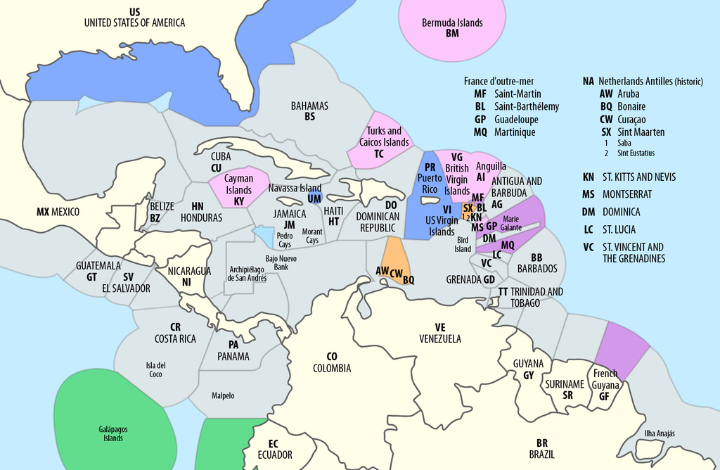
图片作者:Maximilian Dörrbecker (Chumwa) – Own work using: this map by B1mbo
Territorial waters (EEZ) in the Caribbean
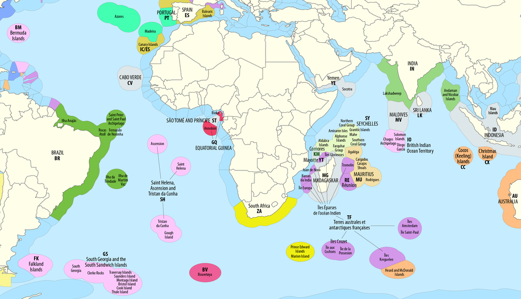
大西洋和印度洋的专属经济区
Maximilian Dörrbecker (Chumwa) – Own work using: this map by B1mbo
Maximilian Dörrbecker (Chumwa) – Own work using: this map by B1mbo
5.2 Algeria 阿尔及利亚
Algeria on 17 April 2018 established an exclusive economic zone (EEZ) off its coasts by Presidential Decree No. 18-96 of 2 Rajab 1439 corresponding to 20 March 2018.[39][40] The permanent mission of Spain to the United Nations on 27 July 2018 declared its disagreement with the EEZ announced by Algeria and that the government of Spain indicated its willingness to enter into negotiations with the government of Algeria with a view to reaching a mutually acceptable agreement on the outer limits of their respective exclusive economic zones,[41] The same was done by the Italian mission on 28 November 2018.[42] The two countries indicated that the Algerian measure had been taken unilaterally and without consulting them.
2018年4月17日,阿尔及利亚通过总统令第18-96号,在其海岸设立了一个专属经济区(EEZ)。西班牙驻联合国常驻代表团于2018年7月27日声明不同意阿尔及利亚宣布的EEZ,并表示愿意与阿尔及利亚政府进行谈判,以达成各自专属经济区外部界限的相互接受的协议。同样,意大利代表团于2018年11月28日也发表了类似的声明。这两个国家指出,阿尔及利亚的措施是单方面采取的,并没有征求他们的意见。
On 25 November 2018, the Algerian Ministry of Foreign Affairs sent an oral note in response to the Spanish protest, explaining that the Algerian government does not recognize the largely exorbitant coordinates contained in Royal Decree 236/2013, which overlap with the coordinates of Presidential Decree n° 18–96 establishing an exclusive economic zone off the coast of Algeria. The Algerian government wished to emphasize that the unilateral delimitation carried out by Spain is not in conformity with the letter of the United Nations Convention on the Law of the Sea and has not taken into consideration the configuration, the specific characteristics, and the special circumstances of the Mediterranean Sea, in particular for the case of the two countries whose coasts are located face to face, as well as the objective rules and relevant principles of international law to govern the equitable delimitation of the maritime areas between Algeria and Spain, in accordance with article 74 of the United Nations Convention on the Law of the Sea. Algeria expressed its willingness to negotiate for a just solution.[43]
2018年11月25日,阿尔及利亚外交部回复了西班牙的抗议,口头传达了一份说明,解释称阿尔及利亚政府不承认西班牙皇家法令236/2013中所包含的大部分过高的坐标,这些坐标与总统令18-96号所设立的阿尔及利亚海岸专属经济区的坐标重叠。阿尔及利亚政府希望强调,西班牙单方面进行的划界并不符合《联合国海洋法公约》的规定,并未考虑到地中海的构造、特殊特征和特殊情况,尤其是对于两国海岸面对面的情况,以及公正划定阿尔及利亚和西班牙海洋区域的客观规则和相关国际法原则,按照《联合国海洋法公约》第74条进行划界。阿尔及利亚表示愿意就公正解决进行谈判。
On 20 June 2019, a communication from Algeria was sent. It was addressed to the Italian embassy[44] and the Spanish embassy in Algiers[45] to show their eligibility in Algeria’s exclusive economic zone.
2019年6月20日,阿尔及利亚发出了一份通信。这份通信寄给了意大利驻阿尔及尔大使馆和西班牙驻阿尔及尔大使馆,以表明它们在阿尔及利亚的专属经济区内的资格。
5.3 Argentina 阿根廷
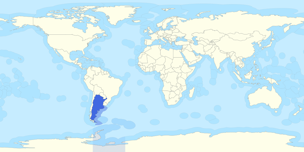
阿根廷的专属经济区,包括其领土主张(福克兰群岛和南乔治亚岛等以及南极洲主张)
图片作者:B1mbo – Own work File:Territorial waters – World.svg
Considering the maritime areas claimed, the total area of Argentina reaches 3,849,756 km2. The recognized Argentine EEZ area is 1,159,063 km2.
考虑到所主张的海域,阿根廷总面积达3,849,756平方公里。 公认的阿根廷专属经济区面积为1,159,063平方公里。
5.4 Australia 澳大利亚
Main article: Exclusive economic zone of Australia
主条目:澳大利亚专属经济区
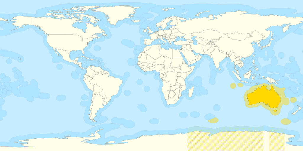
澳大利亚的专属经济区,包括其对南极洲的主权主张
图片作者:B1mbo – Own work File:Territorial waters – World.svg
Australia’s Exclusive Economic Zone was declared on 1 August 1994, and extends from 12 to 200 nautical miles (22 to 370 kilometres) from the coastline of Australia and its external territories, except where a maritime delimitation agreement exists with another state.[46][47] To the 12 nautical miles boundary is Australia’s territorial waters. Australia has the third largest exclusive economic zone, behind France and the United States, but ahead of Russia, with a total area of 8,148,250 square kilometres, which actually exceeds its land territory.
澳大利亚的专属经济区是在1994年8月1日宣布的,从澳大利亚和其外围领土的海岸线起,延伸到12海里(22公里)至200海里(370公里)之间,除非与其他国家存在海洋划界协议。在12海里的范围内是澳大利亚的领海。澳大利亚拥有世界第三大的专属经济区,仅次于法国和美国,但超过俄罗斯,总面积为8,148,250平方公里,实际上超过了其陆地领土的面积。
The United Nations Commission on the Limits of the Continental Shelf (CLCS) confirmed, in April 2008, Australia’s rights over an additional 2.5 million square kilometres of seabed beyond the limits of Australia’s EEZ.[48][49] Australia also claimed, in its submission to the UN Commission on the Limits of the Continental Shelf, additional Continental Shelf past its EEZ from the Australian Antarctic Territory,[50] but these claims were deferred on Australia’s request. However, Australia’s EEZ from its Antarctic Territory is approximately 2 million square kilometres.[49]
联合国大陆架限制委员会(CLCS)于2008年4月确认,澳大利亚在其专属经济区之外的海床上拥有额外的250万平方公里权益。澳大利亚还在其提交给联合国大陆架限制委员会的文件中,声称其在澳大利亚南极领地之外还拥有额外的大陆架权益,但这些声索已经被澳大利亚要求推迟处理。然而,澳大利亚从其南极领地的专属经济区大约有200万平方公里。
| Region 区域 | EEZ Area (km2)[49] 专属经济区 |
|---|---|
| Mainland Australia (5 States and 3 Territories of the Australian Federation), Tasmania, and other minor islands 澳大利亚大陆(澳大利亚联邦的 5 个州和 3 个领地)、塔斯马尼亚州和其他小岛屿 | 6,048,681 |
| Macquarie Island 麦格理岛 | 471,837 |
| 463,371 | |
| 428,618 | |
| Heard Island and McDonald Islands 赫德岛和麦克唐纳群岛 | 410,722 |
| 325,021 | |
| Australian Antarctic Territory 澳大利亚南极领地 | 2,000,000[note 1] |
| Total 合计 | 8,148,250 |
5.5 Brazil 巴西
Main article: Exclusive economic zone of Brazil
主条目:巴西专属经济区
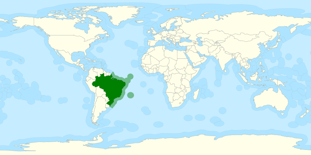
巴西的专属经济区
图片作者:B1mbo – Own work File:Territorial waters – World.svg
Brazil‘s EEZ includes areas around the Fernando de Noronha Islands, Saint Peter and Saint Paul Archipelago, and the Trindade and Martim Vaz Islands. It is called the Blue Amazon.
巴西的专属经济区包括费尔南多-迪诺罗尼亚群岛、圣彼得和圣保罗群岛以及特林达德和马蒂姆瓦茨群岛周围的区域。它被称为蓝色亚马逊。
| Region 区域 | EEZ Area (km2)[51] 专属经济区 |
|---|---|
巴西大陆(巴西联邦的 9 个州) | 2,570,917 |
特林达德和马丁瓦兹群岛 | 468,599 |
圣彼得和圣保罗群岛 | 413,636 |
| Fernando de Noronha Islands 费尔南多·迪诺罗尼亚群岛 | 363,362 |
| Total 总计 | 3,830,955 |
In 2004, Brazil submitted its claims to the United Nations Commission on the Limits of the Continental Shelf (CLCS) to extend its maritime continental margin.[52]
2004年,巴西向联合国大陆架界限委员会(CLCS)提交主张,以扩大其海洋大陆边缘。 [52]
5.6 Canada 加拿大
Main article: Exclusive economic zone of Canada
主条目:加拿大专属经济区
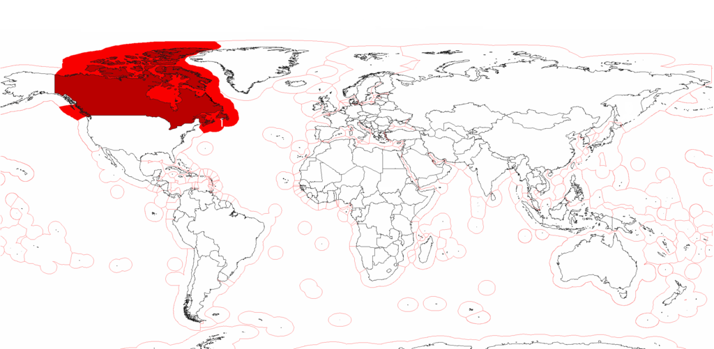
加拿大的专属经济区和领海
图片作者:Pyrophobe
Canada is unusual in that its exclusive economic zone, covering 5,599,077 km2 (2,161,816 sq mi), is slightly smaller than its territorial waters.[53] The latter generally extend only 12 nautical miles from the shore but also include inland marine waters such as Hudson Bay (about 300 nautical miles (560 km; 350 mi) across), the Gulf of Saint Lawrence and the internal waters of the Arctic Archipelago.
加拿大在专属经济区方面比较特殊,其专属经济区面积为5,599,077平方公里(2,161,816平方英里),略小于其领海的面积。后者通常仅从海岸线延伸12海里,但也包括内陆海域,如哈德逊湾(大约跨越300海里(560公里;350英里)),圣劳伦斯湾和北极群岛的内陆水域。
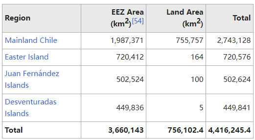
5.7 Chile 智利
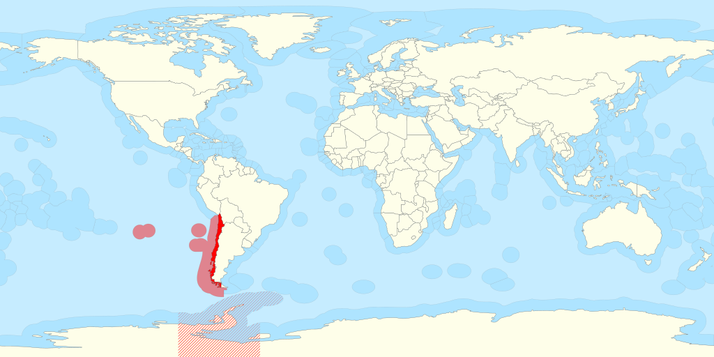
智利的专属经济区,包括其南极宣称
图片作者:B1mbo – Own work based on: Territorial waters – World.svg: by B1mbo
Chile’s EEZ includes areas around the Desventuradas Islands, Easter Island, and the Juan Fernández Islands.
智利的专属经济区包括冒险群岛、复活节岛和胡安·费尔南德斯群岛周围的地区。
In 2020 and 2022, Chile submitted its partial claims to the United Nations Commission on the Limits of the Continental Shelf (CLCS) to extend its maritime continental margin.
2020年和2022年,智利向联合国大陆架界限委员会(CLCS)提交了部分主张,以扩大其海洋大陆边缘。
5.8 China 中国
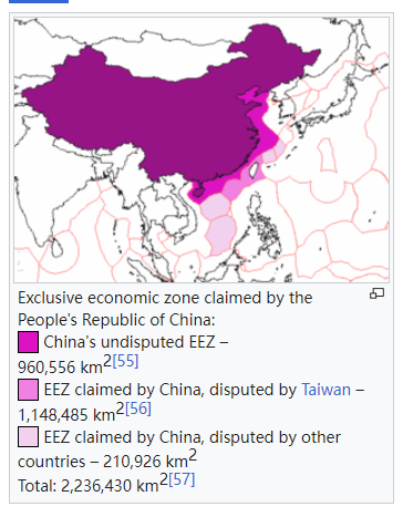
The first figure excludes all disputed waters, while the last figure indicates China’s claimed boundaries, and does not take into account adjacent powers’ claims.[clarification needed]
第一个数字不包括所有有争议的水域,而最后一个数字表示中国主张的边界,并且没有考虑邻国的主张。[需要澄清]
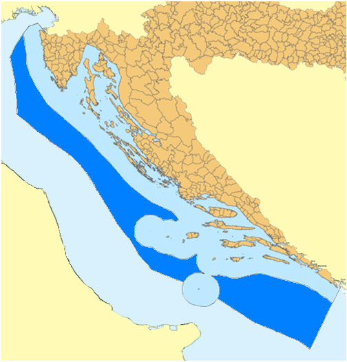
5.9 Croatia 克罗地亚
图片作者:me – Own work
Croatia proclaimed Ecological and Fisheries Protection Zone in 2003, but it was not enforced toward other European Union states especially Italy and Slovenia. The zone was upgraded to EEZ in 2021 together with Italy and Slovenia.[58][59] Territorial waters has 18,981 km2, while internal waters located within the baseline cover an additional 12,498 km2, and EEZ covers 24,482km2 for a total of 55,961km2.
克罗地亚于2003年宣布设立生态和渔业保护区,但并未对其他欧盟国家特别是意大利和斯洛文尼亚执行。 该区于2021年与意大利和斯洛文尼亚一起升级为专属经济区。[58][59] 领海面积为18,981平方公里,基线以内的内水面积为12,498平方公里,专属经济区面积为24,482平方公里,总面积为55,961平方公里。
5.10 Cyprus 塞浦路斯
Cyprus EEZ covers 98,707 square km (38,100 square miles). Cyprus’ EEZ borders those of Greece, Turkey, Syria, Lebanon, Israel and Egypt.
塞浦路斯专属经济区面积 98,707 平方公里(38,100 平方英里)。 塞浦路斯的专属经济区与希腊、土耳其、叙利亚、黎巴嫩、以色列和埃及的专属经济区接壤。
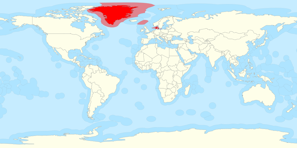
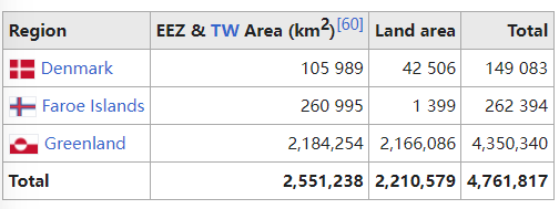
5.11 Denmark 丹麦
图片作者:B1mbo – Own work File:Territorial waters – World.svg
The Kingdom of Denmark includes the constituent country (selvstyre) of Greenland and the constituent country (hjemmestyre) of the Faroe Islands.
丹麦王国包括格陵兰自治领(selvstyre)和法罗群岛自治领(hjemmestyre)。
5.12 Ecuador 厄瓜多尔
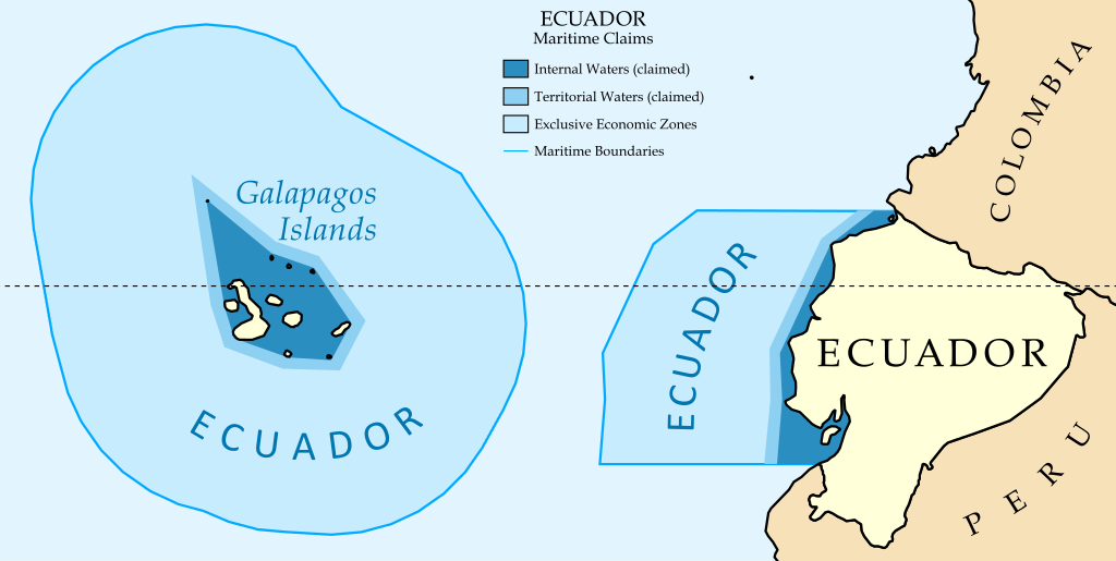
图片作者:Maritime_Claims_of_Peru_and_Ecuador.svg
5.13 France 法国
Main article: Exclusive economic zone of France
图片作者:B1mbo – Own work File:Territorial waters – World.svg
Due to its numerous overseas departments and territories scattered on all oceans of the planet, France possesses the second largest EEZ in the world, covering 10,186,624 km2 (3,933,078 sq mi).[61] The EEZ of France covers approximately 7% of the total surface of all the EEZs of the world, whereas the land area of the French Republic is only 0.45% of the total land area of Earth.
由于法国拥有众多海外省份和领土,分布在全球各大洋,因此拥有世界第二大专属经济区,面积达 10,186,624 平方公里(3,933,078 平方英里)。[61] 法国的专属经济区约占世界所有专属经济区总面积的7%,而法兰西共和国的陆地面积仅占地球陆地总面积的0.45%。
5.14 Germany 德国
Main article: Exclusive economic zone of Germany
主条目:德国专属经济区
The Federal Republic of Germany declared the entry into force of the convention with effect from 1 January 1995, the establishment of a German Exclusive Economic Zone in the North and Baltic Seas.[62] The relevant German legal provisions that are applicable within the exclusive economic zone include the Maritime Task Act (Seeaufgabengesetz) from 1965, the Maritime Facilities Act (Seeanlagengesetz) from 2017, before that the Sea Facilities Ordinance (Seeanlagenverordnung) since 1997, the Federal Mining Act (Bundesberggesetz) and the Regional Planning Act (Raumordnungsgesetz).
德意志联邦共和国宣布该公约自1995年1月1日起生效,在北海和波罗的海建立德国专属经济区。 [62] 适用于专属经济区内的德国相关法律条款包括自 1965 年起的《海事任务法》(Seeaufgabengesetz)、自 2017 年起的《海事设施法》(Seeanlagengesetz)、自 1997 年起的《海洋设施条例》(Seeanlagenverordnung)、《联邦采矿法》 (Bundesberggesetz) 和区域规划法 (Raumordnungsgesetz)。
The German EEZ has an area of 32,982 km2. 70% of the EEZ is the entire German North Sea area and about 29% is the entire German Baltic Sea area.[63]
德国专属经济区面积为32,982平方公里。 专属经济区的 70% 是整个德国北海地区,约 29% 是整个德国波罗的海地区。 [63]
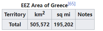
5.15 Greece 希腊
Main article: Exclusive economic zone of Greece
主条目:希腊专属经济区
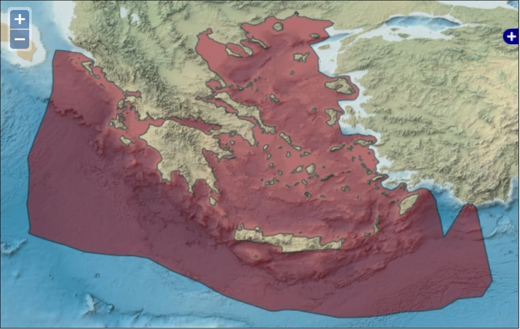
希腊专属经济区
图片作者:Flanders Marine Institute (2020): MarineRegions.org. Available online at www.marineregions.org.
Greece forms the southernmost part of the Balkan peninsula in the Mediterranean Sea. It includes many small islands which vary between 1,200 and 6,000 in the Aegean Sea and the Ionian Sea.[64] The largest islands are Crete, Euboea, Lesbos, Rhodes and Chios.
希腊位于地中海巴尔干半岛的最南端。 它包括爱琴海和爱奥尼亚海的许多小岛屿,数量在 1,200 到 6,000 之间。[64] 最大的岛屿是克里特岛、优卑亚岛、莱斯博斯岛、罗德岛和希俄斯岛。
Greece’s EEZ is bordered to the west by Albania and Italy, to the south by Libya and Egypt, and to the east by Cyprus and Turkey.
希腊专属经济区西边与阿尔巴尼亚和意大利接壤,南边与利比亚和埃及接壤,东边与塞浦路斯和土耳其接壤。
5.16 India 印度
Main article: Exclusive economic zone of India
主条目:印度专属经济区
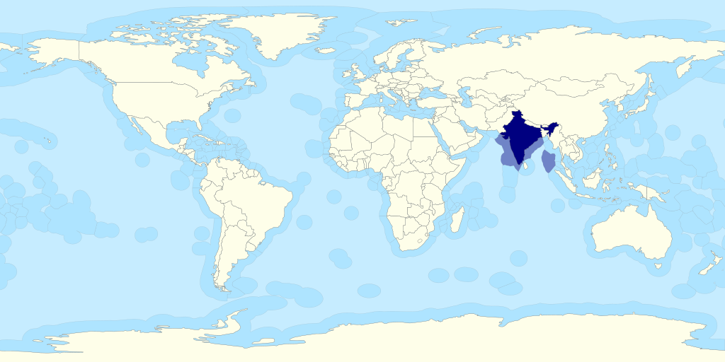
图片作者:B1mbo – Own work File:Territorial waters – World.svg
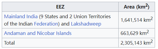
India is currently seeking to extend its EEZ to 350 miles.[66]
印度目前正在寻求将其专属经济区延伸至 350 英里。[66]
5.17 Indonesia 印度尼西亚
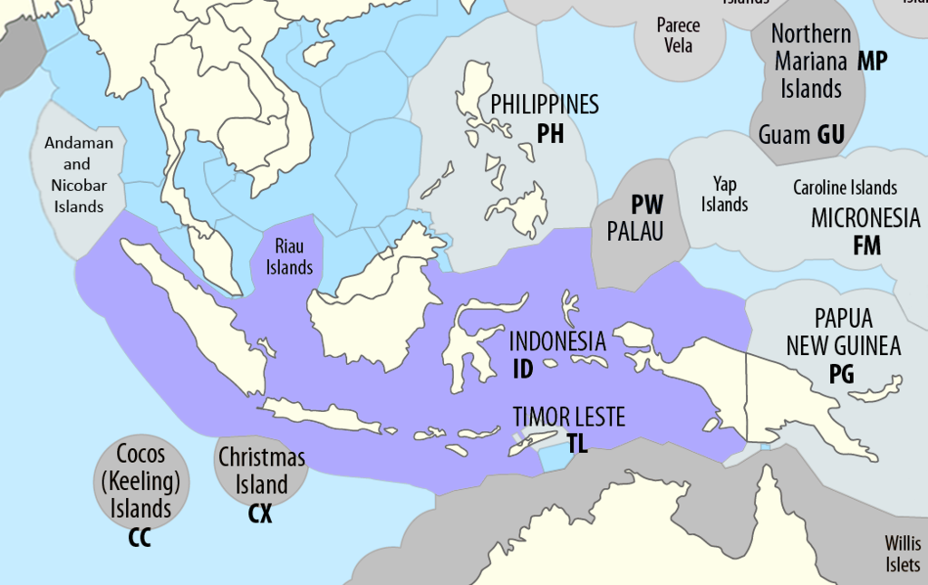
Maximilian Dörrbecker (Chumwa) and B1mbo – Modified version of this map
Main article: Exclusive economic zone of Indonesia
主条目:印度尼西亚专属经济区
Indonesia has the 6th largest exclusive economic zone in the world. The total size is 6,159,032 km2 (2,378,016 sq mi). It claims an EEZ of 200 nautical miles (370 km) from its shores. This is due to the 13,466 islands of the Indonesian Archipelago.[67] It has the 2nd largest coastline of 54,720 km (34,000 mi). The five main islands are: Sumatra, Java, Borneo, Sulawesi, and Western New Guinea. There are two major island groups (Nusa Tenggara and the Maluku Islands) and sixty smaller island groups.
印度尼西亚拥有世界第六大专属经济区。 总面积为 6,159,032 平方公里(2,378,016 平方英里)。 它声称拥有距其海岸 200 海里(370 公里)的专属经济区。 这是由于印度尼西亚群岛有 13,466 个岛屿。[67] 它拥有第二长的海岸线,长达 54,720 公里(34,000 英里)。 五个主要岛屿是:苏门答腊岛、爪哇岛、婆罗洲岛、苏拉威西岛和西新几内亚岛。 有两个主要岛屿群(努沙登加拉岛和马鲁古群岛)和六十个较小的岛屿群。
5.18 Ireland 爱尔兰
Main article: Exclusive economic zone of Ireland
主条目:爱尔兰专属经济区
The Irish Exclusive Economic Zone was announced to be the location of a Russian military exercise in January 2022.[68] The exercise was then moved outside the economic zone.[69]
爱尔兰专属经济区被宣布为 2022 年 1 月俄罗斯军事演习的地点。[68] 随后演习移至经济区之外。[69]
5.19 Israel 以色列
In 2010, an agreement was signed with Cyprus concerning the limit of territorial waters between Israel and Cyprus at the maritime halfway point, a clarification essential for safeguarding Israel’s rights to oil and underwater gas reservoirs. The agreement was signed in Nicosia by Israeli Infrastructure Minister Uzi Landau and the Cypriot Foreign Minister Markos Kyprianou. The two countries agreed to cooperate in the development of any cross-border resources discovered and to negotiate an agreement on dividing joint resources.
2010年,以色列和塞浦路斯签署了一项关于领海边界限制的协议,将领海边界确定为两国之间的海上中点,这一澄清对保护以色列在石油和水下气藏方面的权益至关重要。该协议由以色列基础设施部长乌兹·兰道和塞浦路斯外交部长马尔科斯·基普里安努在尼科西亚签署。两国同意在发现任何跨境资源时进行合作,并就划分共同资源达成协议。
5.20 Italy 意大利
Main article: Exclusive economic zone of Italy
主条目:意大利专属经济区
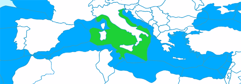
意大利在地中海的专属经济区
图片作者:B1mbo – Modified version of this map by B1mbo File:Territorial_waters_-_World.svg File:Territorial_waters_-_World.svg by B1mbo
Italy has the world’s 48th largest EEZ, with an area of 541,915 km2 (209,235 sq mi).[65] It claims an EEZ of 200 nmi (370.4 km; 230.2 mi) from its shores, which has long coastlines with the Tyrrhenian Sea to the west, the Ionian Sea to the south and the Adriatic Sea to the east. Its EEZ is limited by maritime boundaries with neighboring countries to the northwest, east and southeast.
意大利拥有世界第 48 大专属经济区,面积为 541,915 平方公里(209,235 平方英里)。[65] 它声称拥有距其海岸200海里(370.4公里;230.2英里)的专属经济区,其海岸线很长,西临第勒尼安海,南临爱奥尼亚海,东临亚得里亚海。 其专属经济区受到西北、东部和东南部与邻国的海上边界的限制。
Italy’s western sea territory stretches from the west coast of Italy in the Tyrrhenian Sea including the island Sardinia. The island Sicily is in the southernmost area. Lampedusa is Italy’s southernmost point. It shares treaty-defined maritime boundaries with France, Spain, Algeria, Tunisia, Libya, Malta, Greece, Albania, Montenegro, Croatia and Slovenia.
意大利西部海域从意大利西海岸第勒尼安海延伸,包括撒丁岛。 西西里岛位于最南端。 兰佩杜萨是意大利的最南端。 它与法国、西班牙、阿尔及利亚、突尼斯、利比亚、马耳他、希腊、阿尔巴尼亚、黑山、克罗地亚和斯洛文尼亚共享条约规定的海上边界。
5.21 Japan 日本
Main article: Exclusive economic zone of Japan
主条目:日本专属经济区
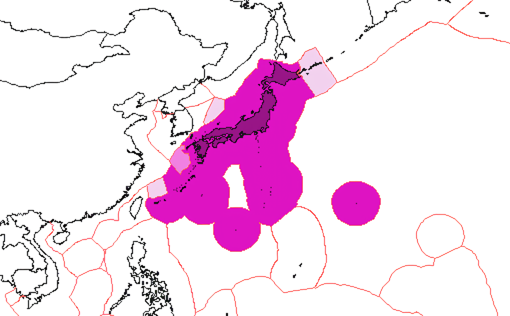
Japan has the 8th largest exclusive economic zone of 4,479,674 km2 (1,729,612 sq mi).[70] It claims an EEZ of 200 nautical miles (370 km) from its shores.
日本拥有第八大专属经济区,面积为 4,479,674 平方公里(1,729,612 平方英里)。[70] 它声称拥有距离其海岸 200 海里(370 公里)的专属经济区。
Japan has disputes over its EEZ boundaries with all its Asian neighbors (China, Russia, South Korea, and Taiwan). The above, and relevant maps at the Sea Around Us Project[72][73][74] both indicate Japan’s claimed boundaries, and do not take into account the claims of adjacent jurisdictions.
日本与其所有亚洲邻国(中国、俄罗斯、韩国和台湾)在专属经济区边界上存在争议。 上述以及我们周围海域项目[72][73][74]的相关地图均标明了日本主张的边界,并没有考虑到邻近管辖区的主张。
Japan also refers to various categories of “shipping area” – Smooth Water Area, Coasting Area, Major or Greater Coasting Area, Ocean Going Area – but it is unclear whether these are intended to have any territorial or economic implications.
日本还提到了各种类别的“航运区”——平静水域、沿海地区、主要或更大沿海地区、远洋地区——但尚不清楚这些是否具有任何领土或经济影响。
5.22 Malaysia 马来西亚
Main article: Exclusive economic zone of Malaysia
主条目:马来西亚专属经济区
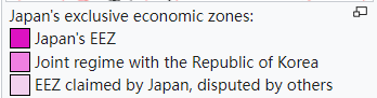
5.23 Mexico 墨西哥
Main article: Exclusive economic zone of Mexico
主条目:墨西哥专属经济区
图片作者:en: user: Dabackgammonator – English wikipedia
Mexico’s exclusive economic zones cover a total surface area of 3,144,295 km2, and places Mexico among the countries with the largest areas in the world.[75] This puts Mexico’s total territory as 5,153,735 km2.
墨西哥专属经济区总面积达3,144,295平方公里,是世界上面积最大的国家之一。 [75] 这使得墨西哥的总领土面积为 5,153,735 平方公里。
5.24 New Zealand 新西兰
Main article: Exclusive economic zone of New Zealand
主条目:新西兰专属经济区
图片作者:B1mbo – Own work File:Territorial waters – World.svg
New Zealand‘s EEZ covers 4,083,744 km2 (1,576,742 sq mi),[76][77] which is approximately fifteen times the land area of the country. Sources vary significantly on the size of New Zealand’s EEZ; for example, a recent government publication gave the area as roughly 4,300,000 km2.[78] These figures are for the EEZ of New Zealand proper, and do not include the EEZs of other territories in the Realm of New Zealand (the Cook Islands, Niue, Tokelau, and the Ross Dependency).
新西兰的专属经济区面积为 4,083,744 平方公里(1,576,742 平方英里),[76][77] 大约是该国陆地面积的十五倍。 关于新西兰专属经济区规模的来源差异很大; 例如,最近的一份政府出版物给出的面积约为 4,300,000 平方公里。[78] 这些数字适用于新西兰本土的专属经济区,不包括新西兰境内其他领土(库克群岛、纽埃、托克劳和罗斯属地)的专属经济区。
5.25 North Korea 朝鲜(北朝鲜)
Main article: Exclusive economic zone of North Korea
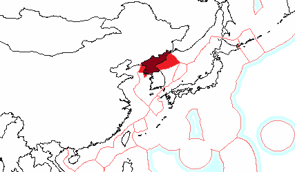
图片作者:Modifications by Finnusertop. Original by Kingj123 at English Wikipedia is based on file by Godefroy.
The exclusive economic zone of North Korea stretches 200 nautical miles from its basepoints in both the West Sea (Yellow Sea) and the Sea of Japan.[79] The EEZ was declared in 1977 after North Korea had contested the validity of the Northern Limit Lines (NLL) set up after the Korean War as maritime borders.[80] The EEZ has not been codified in law and North Korea has never specified its coordinates, making it difficult to determine its specific scope.[81]
朝鲜的专属经济区从西海(黄海)和日本海的基点延伸200海里。 [79] 朝鲜对朝鲜战争后设立的海上边界线(NLL)的有效性提出质疑后,于 1977 年宣布了专属经济区。 [80] 专属经济区尚未编入法律,朝鲜也从未明确其坐标,因此很难确定其具体范围。 [81]
In the West Sea, the EEZ remains unspecified in the Korea Bay because China has not determined its own EEZ in the area.[82] The border between the North Korean and South Korean EEZs in the West Sea cannot be determined because of potential overlap and disputes over certain islands.[83]
在西海,韩国湾的专属经济区仍未明确,因为中国尚未在该地区确定自己的专属经济区。[82] 由于潜在的重叠和某些岛屿的争端,朝鲜和韩国在西海专属经济区之间的边界无法确定。 [83]
In the Sea of Japan, the North Korean EEZ can be approximated to be trapezoidal-shaped.[84] The border between North Korea and Russia’s respective EEZs is the only such border that has been determined in East Asia.[85] Here, the EEZ does not cause many problems, even with regards to South Korea, because the sea is not thought to be rich in resources.[84]
在日本海,朝鲜专属经济区可近似呈梯形。 [84] 朝鲜和俄罗斯各自专属经济区之间的边界是东亚地区唯一已确定的边界。 [85] 在这里,专属经济区不会造成很多问题,即使对于韩国来说也是如此,因为人们认为海洋资源并不丰富。 [84]
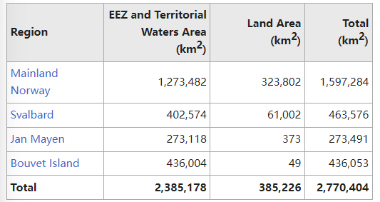
5.26 Norway 挪威
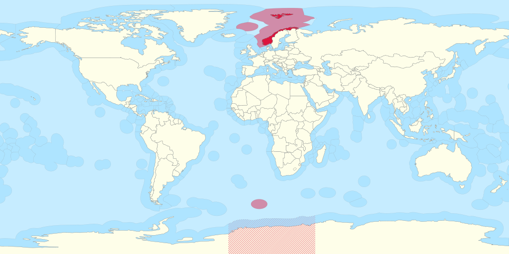
图片作者:B1mbo – Own work File:Territorial waters – World.svg
Norway has a large exclusive economic zone of 819,620 km2 around its coast. The country has a fishing zone of 1,878,953 km2, including fishing zones around Svalbard and Jan Mayen.[86]
挪威在其海岸周围拥有面积达 819,620 平方公里的大型专属经济区。 该国的渔业区面积为 1,878,953 平方公里,其中包括斯瓦尔巴群岛和扬马延岛周围的渔业区。 [86]
In April 2009, the United Nations Commission for the Limits of the Continental Shelf approved Norway’s claim to an additional 235,000 square kilometres of continental shelf. The commission found that Norway and Russia both had valid claims over a portion of the shelf in the Barents Sea.[87]
2009年4月,联合国大陆架界限委员会批准了挪威对额外235,000平方公里大陆架的主张。 该委员会发现挪威和俄罗斯都对巴伦支海的部分大陆架拥有有效的主张。 [87]
5.27 Pakistan 巴基斯坦
Area: 290,000 km2
Pakistan coast is a 1046 km long coast, extending from Sir Creek in the east to Gwadar Bay in the west and the EEZ extends up to 290,000sqkm which is more than 30% of its land area and ranks sixty-sixth in the world by area.
巴基斯坦海岸线长1046公里,东起锡尔溪,西至瓜达尔湾,专属经济区面积达29万平方公里,占其陆地面积的30%以上,面积居世界第66位 。
Pakistan had an EEZ of 240,000sq km before their case was accepted by UNCLCS. Pakistan Navy with the help of the National Oceanographic Organization (NIO) initiated the continental shelf case at ministerial level in 1995.
在《联合国海洋法公约》受理其案件之前,巴基斯坦拥有 24 万平方公里的专属经济区。 巴基斯坦海军在国家海洋学组织 (NIO) 的帮助下于 1995 年启动了部长级大陆架案件。
On 26 Aug 2013, a seven-member sub-commission with members from Japan, China, Mozambique, Kenya, Denmark, Georgia and Argentina was formulated at UNCLCS to evaluate the technical details of Pakistan’s case and after a year accepted Pakistan’s claim.
2013年8月26日,《联合国海洋法公约》成立了一个由日本、中国、莫桑比克、肯尼亚、丹麦、格鲁吉亚和阿根廷组成的七人小组委员会,以评估巴基斯坦案件的技术细节,一年后接受了巴基斯坦的索赔。
On 13 March 2015, UN Commission on the Limits of Continental Shelf (UNCLCS) accepted recommendations for extension of the outer limits of the continental shelf on Pakistan’s case so far 80 countries had submitted claims to UNCLCS out of which recommendations of 22 countries including Pakistan had been finalised.
2015年3月13日,联合国大陆架界限委员会接受了巴基斯坦关于延长大陆架外部界限的建议,目前已有80个国家向UNCLCS提交了主张,其中巴基斯坦等22个国家的建议得到了采纳。 已最终确定。
It was a historic event in the country’s history when Pakistan became the first country in the region to have its continental shelf extended to 350 nm.
巴基斯坦成为该地区第一个将大陆架延伸至350海里的国家,这是该国历史上的历史性事件。
Some of the claimed territories overlapped the Omani claim. It is believed that the verdict in favour of Pakistan was announced after successful negotiation with Oman.
一些声称拥有主权的领土与阿曼的主张重叠。 据信,有利于巴基斯坦的判决是在与阿曼谈判成功后宣布的。
5.28 Peru 秘鲁
Area: 906,454 km2
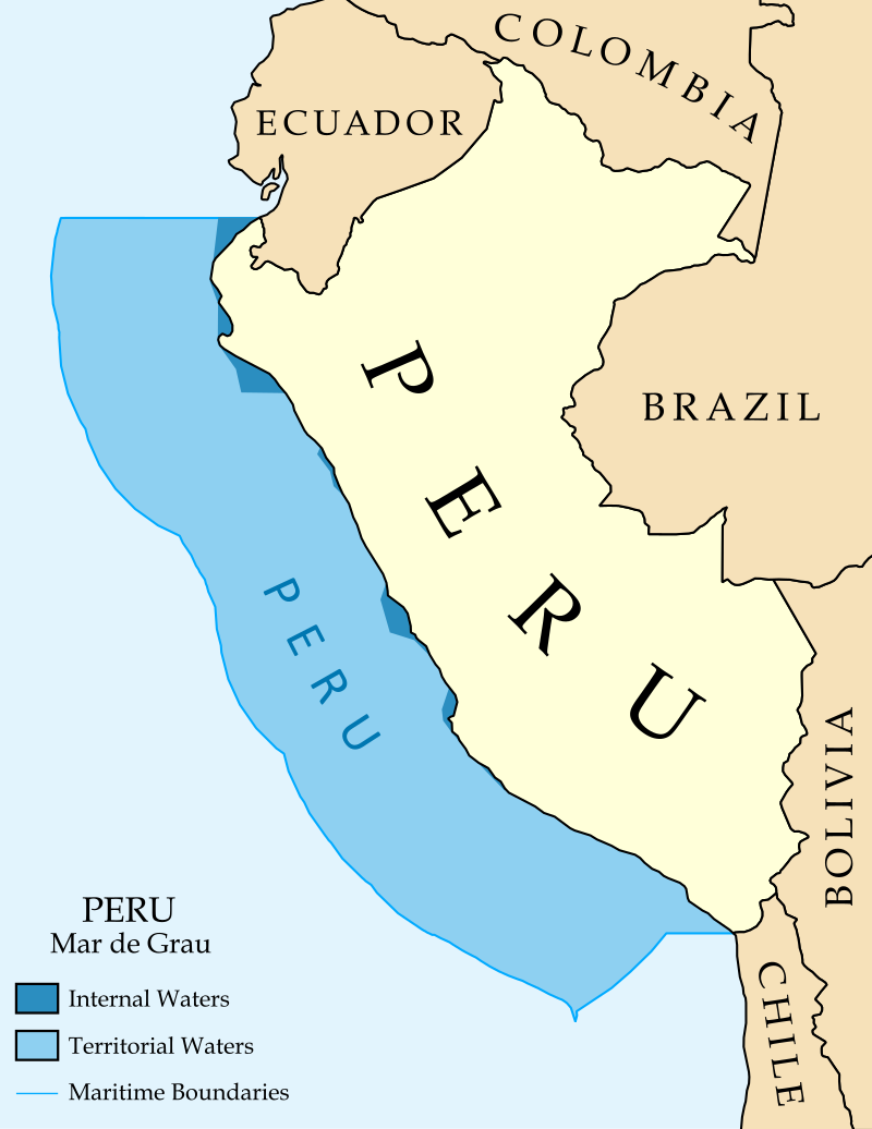
图片作者:Maritime_Claims_of_Peru_and_Ecuador.svg: GeoEvan derivative work: Milenioscuro
5.29 Philippines 菲律宾
Main article: Exclusive economic zone of the Philippines
主条目:菲律宾专属经济区
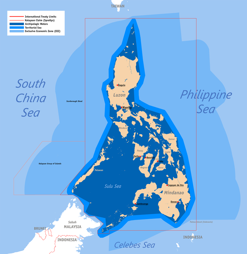
菲律宾的专属经济区以浅蓝色显示,而群岛水域以深蓝色显示。
图片作者:Roel Balingit (username: Namayan)
The Philippines‘ EEZ covers 2,263,816 km2 (874,064 sq mi).[88]
菲律宾的专属经济区面积为 2,263,816 平方公里(874,064 平方英里)。[88]
5.30 Poland 波兰
Main article: Exclusive economic zone of Poland
主条目:波兰专属经济区
The Polish EEZ covers the area of 30,533 km2 (11,789 sq mi) within the Baltic Sea.[89]
波兰专属经济区覆盖波罗的海内 30,533 平方公里(11,789 平方英里)的面积。[89]
5.31 Portugal 葡萄牙
Main article: Exclusive economic zone of Portugal
主条目:葡萄牙专属经济区
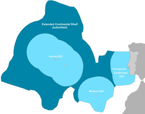
图片作者:Luis wiki at English Wikipedia
Portugal has the 20th largest EEZ in the world. Presently, it is divided in three non-contiguous sub-zones:
葡萄牙拥有世界第 20 大专属经济区。 目前,它分为三个不连续的子区域:
- Continental Portugal 327,667 km2 葡萄牙大陆 327,667 平方公里
- Azores 953,633 km2 亚速尔群岛 953,633 平方公里
- Madeira 446,108 km2 马德拉群岛 446.108 平方公里
- Total : 1,727,408 km2 总计:1,727,408 平方英里
Portugal submitted a claim to extend its jurisdiction over an additional 2.15 million square kilometres of the adjacent continental shelf in May 2009,[91] resulting in an area with a total of more than 3,877,408 km2. The submission, as well as a detailed map, can be found in the Task Group for the extension of the Continental Shelf website.
葡萄牙于 2009 年 5 月提出将其管辖范围扩大到邻近大陆架的另外 215 万平方公里,[91] 使该大陆架的总面积超过 3,877,408 平方公里。 提交的内容以及详细地图可以在大陆架扩展任务组网站上找到。
Spain previously objected to the EEZ’s southern border, maintaining that it should be drawn halfway between Madeira and the Canary Islands. But Portugal exercises sovereignty over the Savage Islands, a small archipelago north of the Canaries, claiming an EEZ border further south. Spain has no longer disputed the Portuguese claim since 2015.[92][93]
西班牙此前反对专属经济区的南部边界,坚持认为该边界应画在马德拉群岛和加那利群岛之间。 但葡萄牙对加那利群岛以北的一个小群岛萨维奇群岛行使主权,并声称拥有更南边的专属经济区边界。 自2015年以来,西班牙不再对葡萄牙的主权主张提出异议。[92][93]
5.32 Romania 罗马尼亚
Area: 23,627 km2
5.33 Russia 俄罗斯
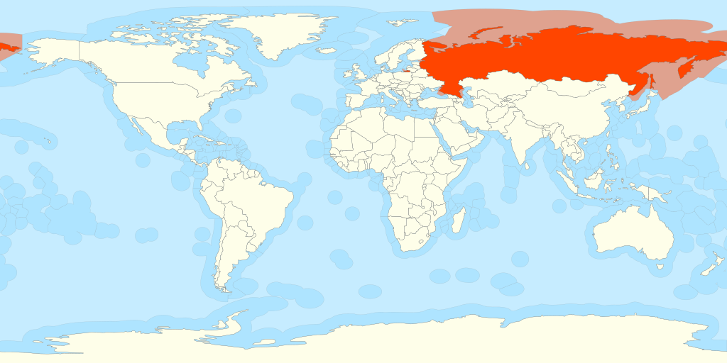
图片作者:B1mbo – Own work File:Territorial waters – World.svg
Main article: Exclusive economic zone of Russia
主条目:俄罗斯专属经济区
4th largest 第四大(专属经济区)
- Kaliningrad (Baltic Sea) – 11,634 km2
加里宁格勒(波罗的海) – 11,634 平方公里 - Saint Petersburg (Baltic Sea) – 12,759 km2
圣彼得堡(波罗的海) – 12,759 平方公里 - Barents Sea – 1,308,140 km2
巴伦支海 – 1,308,140 平方公里 - Black Sea (without the Crimean EEZ) – 66,854 km2
黑海(不包括克里米亚专属经济区)——66,854 平方公里 - Pacific – 3,419,202 km2
太平洋 – 3,419,202 平方公里 - Siberia – 3,277,292 km2
西伯利亚 – 3,277,292 平方公里 - Total – 8,095,881 km2[94]
总计 – 8,095,881 平方公里[94]
5.34 Senegal 塞内加尔
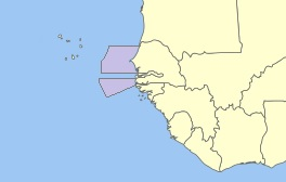
图片作者:Benj90
Area: 158,861 km2
5.35 Somalia 索马里
Main article: Exclusive economic zone of Somalia
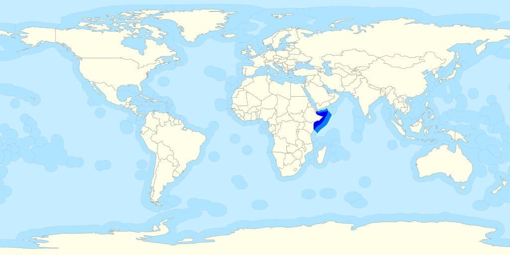
图片作者:26oo at English Wikipedia
Area: 825,052 km2
5.36 South Africa
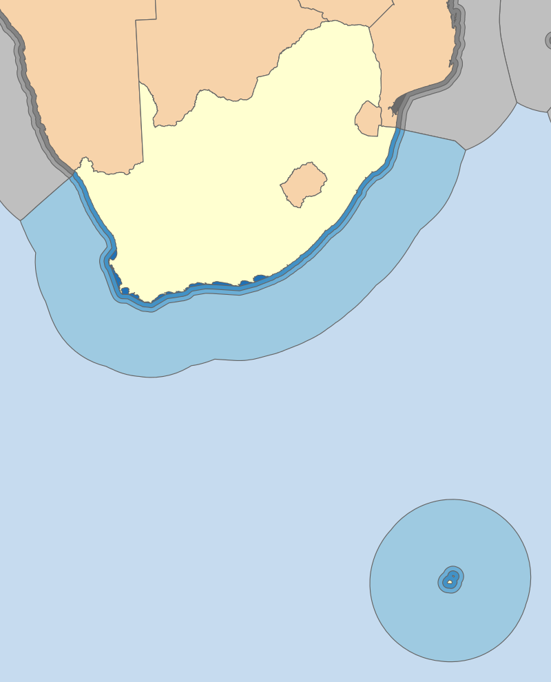
图片作者:Htonl
South Africa’s EEZ includes both that next to the African mainland and that around the Prince Edward Islands, totalling 1,535,538 km2.[65]
南非的专属经济区包括非洲大陆附近的区域和爱德华王子岛周围的区域,总面积为 1,535,538 平方公里。[65]
- Mainland – 1,068,659 km2
- Prince Edward islands – 466,879 km2
5.37 South Korea 韩国(南朝鲜)
See also: Syngman Rhee Line
另见:李承晚线
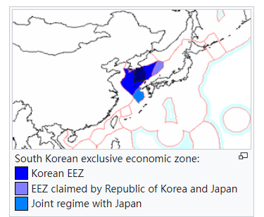
Area: 300,851 (225,214) km2
5.38 Spain 西班牙
Main article: Exclusive economic zone of Spain
Area: 1,039,233 km2
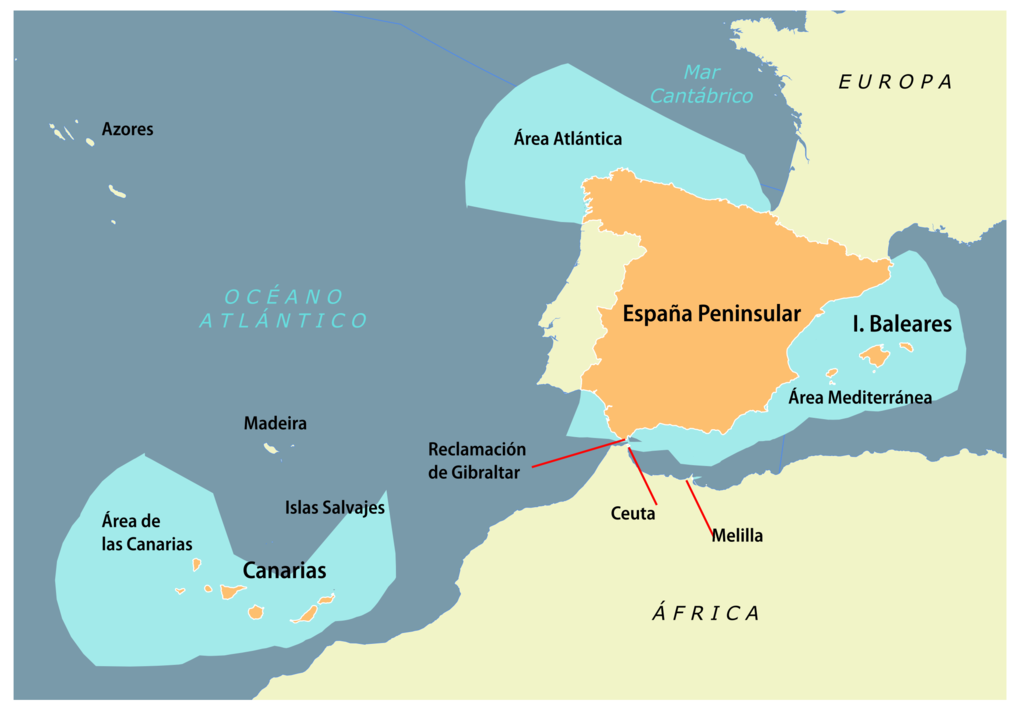
图片作者:NACLE
5.39 Thailand 泰国
Main article: Exclusive economic zone of Thailand
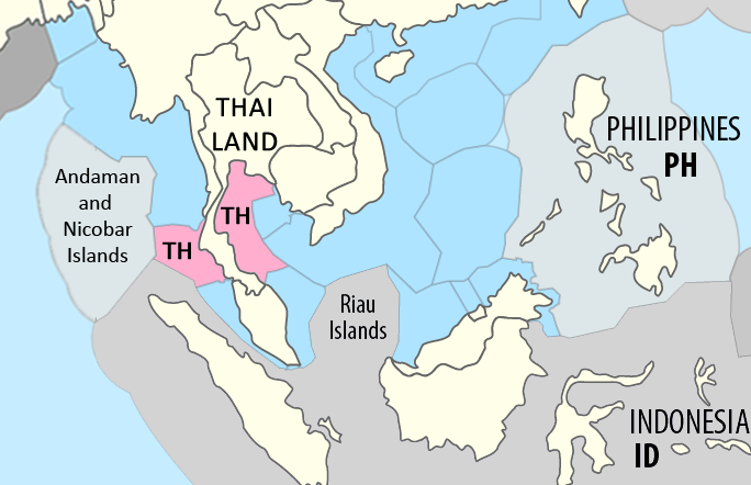
图片作者:Maximilian Dörrbecker (Chumwa) and B1mbo – Modified version of this map by Maximilian Dörrbecker (Chumwa)
Area: 299,397 km2
5.40 Turkey 土耳其
Turkey’s EEZ is bordered by Georgia, Russia, Ukraine, Romania and Bulgaria in the Black Sea to the north, Greece in the Aegean Sea to the west, and Cyprus and Syria in the Mediterranean Sea to the south. Turkey is one of the few countries to not have signed UNCLOS and disputes Greece’s and Cyprus’ EEZ.
土耳其专属经济区北临黑海与格鲁吉亚、俄罗斯、乌克兰、罗马尼亚和保加利亚接壤,西临爱琴海与希腊接壤,南临地中海与塞浦路斯和叙利亚接壤。 土耳其是少数几个没有签署《联合国海洋法公约》的国家之一,并且对希腊和塞浦路斯的专属经济区存在争议。
5.41 United Kingdom 英国
Main article: Exclusive economic zone of the United Kingdom
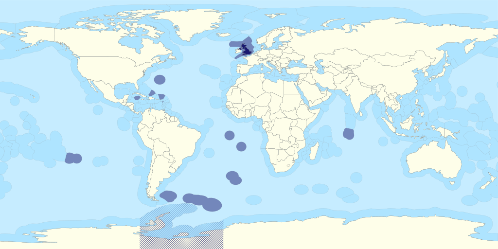
英国的专属经济区以蓝色显示,包括英国海外领土和皇家属地。 英国对南极洲的主权主张以蓝色阴影显示。[95]
图片作者:B1mbo – Own work Territorial waters – World.svg
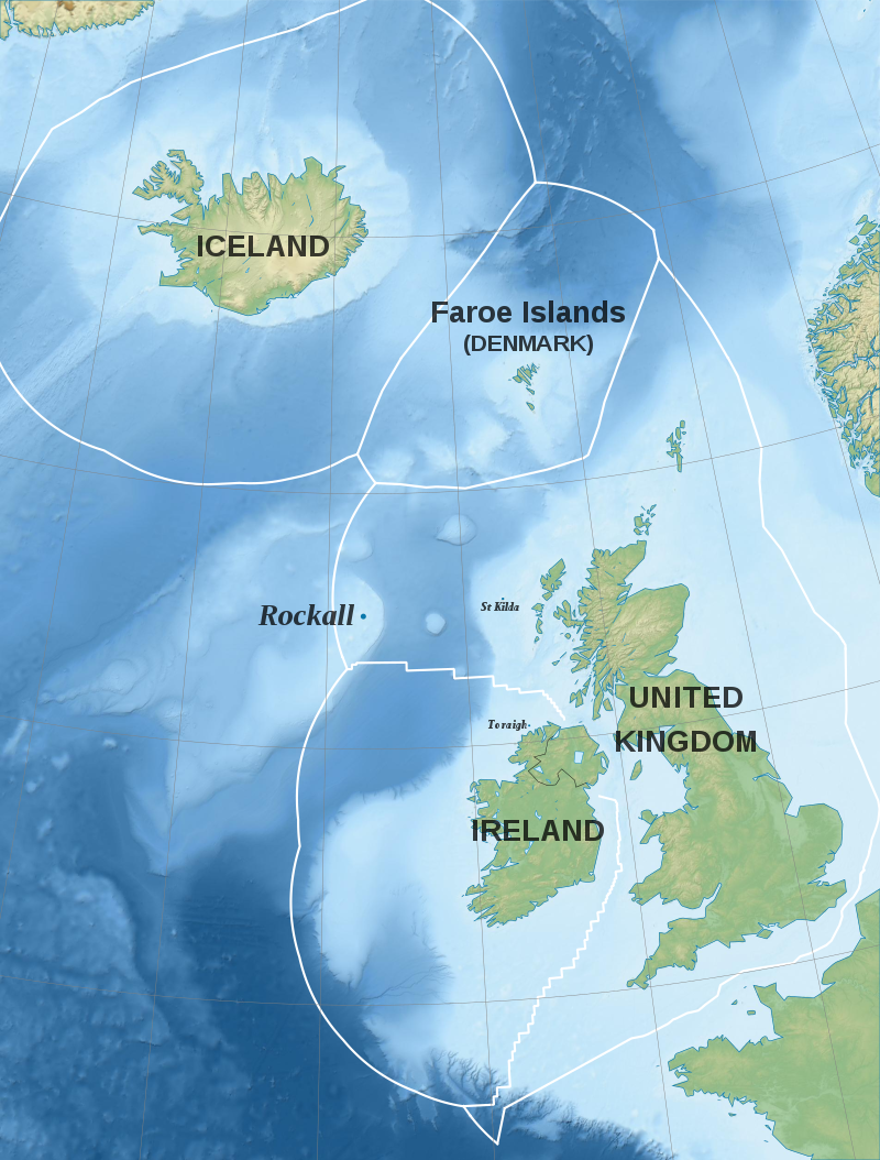
英国、冰岛和法罗群岛的专属经济区
图片作者:Liam Mason – Own work Source : Topography & Bathymetry : SRTM30 Plus Shorelines : NGDC GSHHS Exclusive Economic Zones: Maritime Boundaries Geodatabase: Maritime Boundaries and Exclusive Economic Zones (200NM), version 10
The United Kingdom has the fifth largest exclusive economic zone of 6,805,586 km2 (2,627,651 sq mi) square km. It comprises the EEZs surrounding the United Kingdom,[96] the Crown Dependencies, and the British Overseas Territories. The figure does not include the EEZ of the British Antarctic Territory.
英国拥有第五大专属经济区,面积为 6,805,586 平方公里(2,627,651 平方英里)平方公里。 它包括英国周围的专属经济区、[96] 皇家属地和英国海外领土。 该数字不包括英属南极领地的专属经济区。
The EEZ associated with the Falkland Islands and South Georgia are disputed by Argentina. The EEZ of the Chagos Archipelago, also known as the British Indian Ocean Territory, is also disputed with Mauritius which considers the archipelago as a part of its territory.
阿根廷对与福克兰群岛和南乔治亚岛相关的专属经济区存在争议。 查戈斯群岛的专属经济区(也称为英属印度洋领地)也与毛里求斯存在争议,毛里求斯认为该群岛是其领土的一部分。
| Territory 领地 | EEZ Area (km2) 专属经济区(公制单位) | EEZ Area (sq mi)专属经济区(英制单位) | Notes 备注 |
|---|---|---|---|
南乔治亚岛和南桑威奇群岛 | 1,449,532 | 559,667 | Disputed with 与阿根廷争议 |
皮特凯恩岛、亨德森岛、迪西岛和奥埃诺岛 | 836,108 | 322,823 | |
联合王国 | 773,676 | 298,718 | Including the 包含马恩岛 |
特里斯坦·达库尼亚† | 754,720 | 291,400 | Including 包括高夫岛。 |
英属印度洋领地 | 638,568 | 246,552 | Disputed with 与毛里求斯有争议。 |
福克兰群岛 | 550,872 | 212,693 | Disputed with 与阿根廷争议。 |
百慕大 | 450,370 | 173,890 | |
圣赫勒拿† | 444,916 | 171,783 | |
阿森松岛† | 441,658 | 170,525 | |
特克斯和凯科斯群岛 | 154,068 | 59,486 | |
开曼群岛 | 119,137 | 45,999 | |
安圭拉 | 92,178 | 35,590 | |
英属维尔京群岛 | 80,117 | 30,933 | |
海峡群岛 | 11,658 | 4,501 | Including 包括根西岛和泽西岛。 |
蒙特塞拉特 | 7,582 | 2,927 | |
直布罗陀 | 426 | 164 | Disputed with 与西班牙争议 |
阿克罗蒂里和德凯利亚主权根据地 | 0 | 0 | No EEZ area. The relevant EEZ areas around Cyprus Island are claimed by the 无专属经济区。 塞浦路斯共和国[97]和北塞浦路斯[98]声称对塞浦路斯岛周围的相关专属经济区拥有主权。 |
| Total | 6,805,586 | 2,627,651 |
† A part of the overseas territory of ![]() Saint Helena, Ascension and Tristan da Cunha, which together has an EEZ of 1,641,294 square km.
Saint Helena, Ascension and Tristan da Cunha, which together has an EEZ of 1,641,294 square km.
圣赫勒拿岛、阿森松岛和特里斯坦达库尼亚岛海外领土的一部分,专属经济区总面积为 1,641,294 平方公里。
5.42 United States 美国
Main article: Exclusive economic zone of the United States
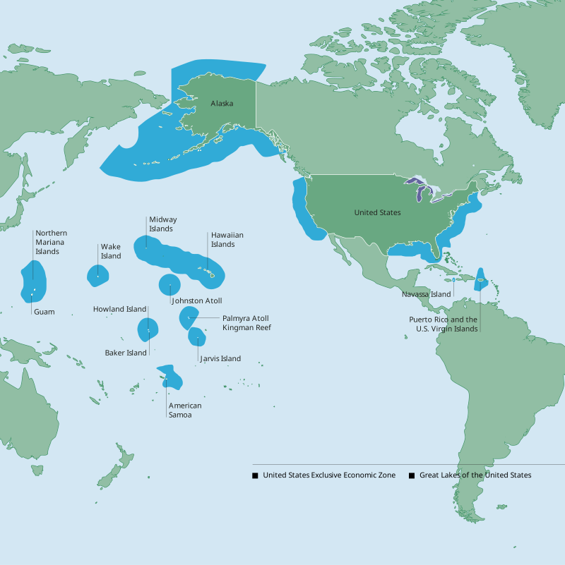
图片作者:National Oceanic and Atmospheric Administration – http://www.gc.noaa.gov/documents/2011/012711_gcil_maritime_eez_map.pdf
The United States’ exclusive economic zone is the largest in the world, covering 11,351,000 km2. Areas of its EEZ are located in three oceans, the Gulf of Mexico, and the Caribbean Sea.
美国的专属经济区是世界上最大的,面积为 11,351,000 平方公里。 其专属经济区位于墨西哥湾和加勒比海三大洋。
The EEZ (including territorial sea) areas of the territories of the U.S. (in decreasing size)[99]
美国领土的专属经济区(包括领海)区域(面积不断缩小)[99]
| Territory 领地 | EEZ Area (km2) 专属经济区(公制单位) | EEZ Area (sq mi) 专属经济区(英制单位) | Notes 备注 |
|---|---|---|---|
阿拉斯加 | 3,770,021 | 1,455,613 | A non-contiguous state in the northwest extremity of the North American continent. 北美大陆西北端的一个不相连的州。 |
夏威夷 – 西北群岛 | 1,579,538 | 609,863 | Including Midway Atoll, these islands form the Leeward Islands of the Hawaiian island chain. 包括中途岛环礁在内,这些岛屿构成了夏威夷群岛的背风群岛。 |
美国东海岸 | 915,763 | 353,578 | The mainland coastal states of the Eastern United States. As a region, this term most often refers to the coastal states of Maine, New Hampshire, Massachusetts, Rhode Island, Connecticut, New York, New Jersey, Delaware, Maryland, Virginia, North Carolina, South Carolina, Georgia, and the Atlantic Coast of Florida. 美国东部大陆沿海各州。 作为一个地区,该术语通常指缅因州、新罕布什尔州、马萨诸塞州、罗德岛州、康涅狄格州、纽约州、新泽西州、特拉华州、马里兰州、弗吉尼亚州、北卡罗来纳州、南卡罗来纳州、佐治亚州和大西洋海岸等沿海州 佛罗里达州。 |
夏威夷 – 东南群岛 | 895,346 | 345,695 | These islands form the Windward Islands of the Hawaiian island chain. 这些岛屿构成了夏威夷群岛的向风群岛。 |
美国西海岸 | 825,549 | 318,746 | The mainland coastal states of the Western United States. As a region, this term most often refers to the coastal states of California, Oregon, Washington. 美国西部大陆沿海各州。 作为一个地区,该术语通常指加利福尼亚州、俄勒冈州、华盛顿州等沿海州。 |
北马里亚纳群岛 | 749,268 | 289,294 | An organized unincorporated Commonwealth of the United States. 一个有组织的未设州的美国自治领土。 |
美国墨西哥湾海岸 | 707,832 | 273,295 | The mainland coastal states of the Southern United States. As a region, this term most often refers to the coastal states of Texas, Louisiana, Mississippi, Alabama, and the Gulf Coast of Florida 美国南部大陆沿海各州。 作为一个地区,该术语通常指德克萨斯州、路易斯安那州、密西西比州、阿拉巴马州和佛罗里达州墨西哥湾沿岸的沿海州 |
约翰斯顿环礁 | 442,635 | 170,902 | A National Wildlife Refuge in the U.S. Minor Outlying Islands. 美国本土小岛屿国家野生动物保护区。 |
豪兰和贝克群岛 | 434,921 | 167,924 | Including Howland Island and Baker Island, both territories are National Wildlife Refuges in the U.S. Minor Outlying Islands. 包括豪兰岛和贝克岛,这两个领土都是美国本土小岛屿的国家野生动物保护区。 |
威克岛 | 407,241 | 157,237 | A National Wildlife Refuge in the U.S. Minor Outlying Islands. 美国本土小岛屿国家野生动物保护区。 |
美属萨摩亚 | 404,391 | 156,136 | The only inhabited unorganized unincorporated territory of the United States. 美国唯一有人居住的无建制非州领土。 |
| Palmyra Atoll and Kingman Reef 巴尔米拉环礁和金曼礁 | 352,300 | 136,000 | Both territories are National Wildlife Refuges in the U.S. Minor Outlying Islands. 这两个地区都是美国外岛小岛的国家野生动物保护区。 |
| Jarvis Island 贾维斯岛 | 316,665 | 122,265 | A National Wildlife Refuge in the U.S. Minor Outlying Islands. 美国本土小岛屿国家野生动物保护区。 |
关岛 | 221,504 | 85,523 | An organized unincorporated territory of the United States. 美国有组织的非州领土。 |
波多黎各 | 177,685 | 68,605 | An organized unincorporated Commonwealth of the United States. 美国有组织的非州领土。 |
美属维尔京群岛 | 33,744 | 13,029 | An organized unincorporated territory of the United States. 美国有组织的非州领土。 |
| Navassa Island 纳瓦萨岛 | N/A[note 2] | N/A[note 2] | A National Wildlife Refuge in the U.S. Minor Outlying Islands. A joint Cuba–Haiti Maritime Boundary Agreement signed at Havana in 1977 bilaterally divides the waters between both local nations and Cuba’s maritime boundary places the island within Haitian waters and doesn’t recognize any local U.S. claim in the area. 美国本土小岛屿国家野生动物保护区。 1977 年在哈瓦那签署的古巴-海地联合海上边界协议划分了两国之间的双边水域,古巴的海上边界将该岛置于海地水域内,并且不承认美国对该地区的任何当地主权主张。 |
| Total | 11,351,000 | 4,383,000 |
Note, the totals in the table actually add up to 12,234,403 square km and 4,723,705 square miles.
请注意,表中的总面积实际上总计为 12,234,403 平方公里和 4,723,705 平方英里。
5.43 Vietnam 越南
Main article: Exclusive economic zone of Vietnam
主条目:越南专属经济区
Main article: Territorial disputes in the South China Sea
主条目:南海领土争端
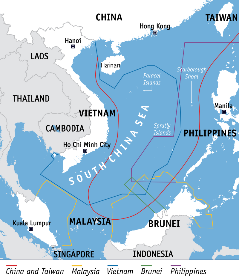
在南中国海的领土主张。 越南的专属经济区有一条蓝线。
图片作者:Voice of America (vectorised by HueMan1) – http://blogs.voanews.com/state-department-news/2012/07/31/challenging-beijing-in-the-south-china-sea/
SVG version of the South China Sea claims map by Voice of America
Vietnam claims an exclusive economic zone (EEZ) of 1,395,096 km2 (538,650 sq mi) with 200 nautical miles (370.4 km; 230.2 mi) from its shores.[103][104]
越南声称拥有面积 1,395,096 平方公里(538,650 平方英里)的专属经济区(EEZ),距其海岸 200 海里(370.4 公里;230.2 英里)。[103][104]
Excluding all disputed waters, Vietnam has an undisputed exclusive economic zone of 417,663 km2 (161,261 sq mi).[citation needed] This figure does not include the claimed EEZ areas of the Paracel Islands and the Spratly Islands. Vietnam has disputes mainly with the People’s Republic of China due to the nine-dash line.
排除所有有争议的水域,越南拥有无可争议的417,663平方公里(161,261平方英里)的专属经济区。[需要引用]这个数字不包括声称拥有主权的西沙群岛和南沙群岛专属经济区。 越南与中华人民共和国主要因九段线而存在争议。
6. Rankings by area 面积排名
This list includes dependent territories (including uninhabited territories) within their sovereign states, but does not include various claims on Antarctica. EEZ+TIA is exclusive economic zone (EEZ) plus total internal area (TIA) which includes territorial land and internal waters.
该清单包括其主权国家内的附属领土(包括无人居住的领土),但不包括对南极洲的各种主张。 EEZ+TIA 是专属经济区 (EEZ) 加上内部总面积 (TIA),其中包括领海和内水。
图片来源: EEZ_France.png: Godefroy derivative work: Keltorrics (talk) – EEZ_France.png
| Rank | Country | EEZ km2[65] | Shelf km2 | EEZ+TIA km2 |
|---|---|---|---|---|
| 1 | 11,691,624 | 725,297 | 12,416,921 | |
| 2 | 11,351,000 | 2,193,526 | 21,814,306 | |
| 3 | 9,025,053 | 2,194,008 | 16,197,464 | |
| 4 | 7,566,673 | 3,817,843 | 24,664,915 | |
| 5 | 6,805,586 | 872,891 | 7,048,486 | |
| 6 | 6,159,032 | 2,039,381 | 8,063,601 | |
| 7 | 5,599,077 | 2,644,795 | 15,607,077 | |
| 8 | 4,479,388 | 214,976 | 4,857,318 | |
| 9 | 4,420,565[76][77][105] | 272,898[76][77][105] | 4,688,285[106][107] | |
| 10 | 3,830,955 | 774,563 | 12,345,832 | |
| 11 | 3,681,989 | 252,947 | 4,431,381 | |
| 12 | 3,441,810 | 7,523 | 3,442,536 | |
| 13 | 3,269,386 | 419,102 | 5,141,968 | |
| 14 | 2,996,419 | 19,403 | 2,997,121 | |
| 15 | 2,551,238 | 495,657 | 4,761,811 | |
| 16 | 2,402,288 | 191,256 | 2,865,128 | |
| 17 | 2,385,178 | 434,020 | 2,770,404 | |
| 18 | 2,305,143 | 402,996 | 5,592,406 | |
| 19 | 1,990,530 | 18,411 | 1,990,711 | |
| – | Cook Islands[note 10] | 1,960,027 | 1,213 | 1,960,267 |
| 20 | 1,727,408 | 28,000 | 1,819,498 | |
| 21 | 1,590,780 | 272,921 | 1,890,780 | |
| 22 | 1,589,477 | 36,282 | 1,618,373 | |
| 23 | 1,535,538 | 156,337 | 2,756,575 | |
| 24 | 1,336,559 | 39,063 | 1,337,014 | |
| 25 | 1,284,997 | 29,061 | 1,287,037 | |
| 26 | 1,282,978 | 47,705 | 1,301,250 | |
| 27 | 1,225,259 | 101,505 | 1,812,300 | |
| 28 | 1,159,063 | 856,346 | 3,939,463[108] | |
| 29 | 1,077,231 | 41,034 | 1,333,600 | |
| 30 | 1,039,233 | 77,920 | 1,545,225 | |
| 31 | 923,322 | 34,538 | 923,622 | |
| 32 | 906,454 | 82,000 | 2,191,670 | |
| 33 | 877,019 | 231,340 | 10,473,980 | |
| 34 | 825,052 | 55,895 | 1,462,709 | |
| 35 | 808,158 | 53,691 | 1,949,906 | |
| 36 | 800,561 | 5,591 | 804,594 | |
| 37 | 751,345 | 108,015 | 854,345 | |
| 38 | 749,790 | 3,575 | 749,816 | |
| 39 | 663,251 | 11,483 | 675,440 | |
| 40 | 659,558 | 8,517 | 660,305 | |
| 41 | 654,715 | 106,323 | 668,658 | |
| 42 | 603,978 | 2,837 | 604,437 | |
| 43 | 578,986 | 94,212 | 1,380,576 | |
| 44 | 575,230 | 115,157 | 1,287,780 | |
| 45 | 574,725 | 19,585 | 625,825 | |
| 46 | 564,748 | 86,698 | 1,388,864 | |
| 47 | 552,669 | 59,229 | 1,080,637 | |
| 48 | 541,915 | 116,834 | 843,251 | |
| 49 | 533,180 | 59,071 | 842,680 | |
| 50 | 532,775 | 220,332 | 1,209,353 | |
| 51 | 532,619 | 32,453 | 598,229 | |
| 52 | 518,433 | 48,092 | 1,765,133 | |
| 53 | 505,572 | 81,451 | 637,529 | |
| 54 | 475,469 | 342,522 | 575,469 | |
| 55 | 471,507 | 98,500 | 1,387,950 | |
| 56 | 417,663 | 365,198 | 748,875 | |
| 57 | 410,310 | 139,935 | 480,583 | |
| 58 | 351,589 | 64,763 | 2,111,129 | |
| 59 | 350,751 | 61,525 | 460,637 | |
| 60 | 335,646 | 53,404 | 411,163 | |
| 61 | 334,671 | 323,412 | 665,474 | |
| – | Niue[note 10] | 316,584 | 284 | 316,844 |
| 62 | 308,480 | 41 | 308,501 | |
| 63 | 303,509 | 7,820 | 331,560 | |
| 64 | 299,397 | 230,063 | 812,517 | |
| 65 | 290,000 | 51,383 | 1,117,911 | |
| 66 | 263,451 | 61,591 | 1,265,451 | |
| 67 | 261,654 | 56,093 | 1,045,216 | |
| 68 | 258,137 | 9,802 | 269,128 | |
| 69 | 255,898 | 10,738 | 304,569 | |
| 70 | 249,734 | 17,715 | 361,103 | |
| 71 | 249,542 | 68,718 | 362,034 | |
| 72 | 241,888 | 25,611 | 1,186,975 | |
| 73 | 235,349 | 22,502 | 473,888 | |
| 74 | 228,633 | 107,249 | 2,378,323 | |
| 75 | 217,313 | 42,285 | 1,141,081 | |
| 76 | 215,611 | 28,625 | 287,351 | |
| 77 | 202,790 | 35,020 | 470,458 | |
| 78 | 186,898 | 426 | 187,328 | |
| 79 | 176,254 | 10,175 | 498,717 | |
| 80 | 168,718 | 118,693 | 1,797,468 | |
| 81 | 165,338 | 31,662 | 1,190,858 | |
| 82 | 163,752 | 1,526 | 165,987 | |
| 83 | 160,885 | 154,604 | 602,255 | |
| 84 | 158,861 | 23,092 | 355,583 | |
| 85 | 154,011 | 77,246 | 192,345 | |
| 86 | 147,318 | 79,142 | 750,818 | |
| 87 | 142,166 | 75,327 | 318,381 | |
| 88 | 137,765 | 50,578 | 352,734 | |
| 89 | 131,397 | 1,902 | 132,361 | |
| 90 | 127,950 | 2,087 | 130,781 | |
| 91 | 127,772 | 53,631 | 291,592 | |
| 92 | 126,760 | 6,683 | 154,510 | |
| 93 | 126,353 | 9,985 | 2,508,094 | |
| 94 | 123,881 | 70,874 | 254,254 | |
| 95 | 123,725 | 39,339 | 159,850 | |
| 96 | 118,813 | 66,438 | 230,390 | |
| 97 | 116,942 | 11,073 | 697,309 | |
| 98 | 114,170 | 14,422 | 223,059 | |
| 99 | 113,888[109][110] | 50,337[109][110] | 234,428[111] | |
| 100 | 110,089 | 4,128 | 110,531 | |
| 101 | 101,857 | 67,126 | 265,467 | |
| 102 | 98,707 | 4,042 | 107,958 | |
| 103 | 90,962 | 16,852 | 112,003 | |
| 104 | 87,171 | 85,109 | 425,590 | |
| 105 | 83,231 | 43,016 | 119,419 | |
| 106 | 77,728 | 61,817 | 195,328 | |
| 107 | 74,199 | 25,284 | 79,329 | |
| 108 | 70,326 | 25,648 | 85,200 | |
| 109 | 68,148 | 19,827 | 1,954,216 | |
| 110 | 62,515 | 62,515 | 243,550 | |
| 111 | 59,426 | 44,755 | 305,283 | |
| 112 | 59,032 | 50,277 | 115,626 | |
| 113 | 58,218 | 57,474 | 141,818 | |
| 114 | 57,485 | 57,485 | 414,599 | |
| 115 | 54,823 | 5,301 | 55,139 | |
| 116 | 36,992 | 36,992 | 82,219 | |
| 117 | 36,302 | 1,561 | 36,691 | |
| 118 | 35,351 | 13,178 | 58,317 | |
| 119 | 34,307 | 10,426 | 145,186 | |
| 120 | 33,221 | 2,721 | 145,843 | |
| 121 | 31,590 | 31,590 | 43,176 | |
| 122 | 31,017 | 7,982 | 373,017 | |
| 123 | 29,797 | 29,797 | 342,482 | |
| 124 | 28,985 | 659 | 29,736 | |
| 125 | 28,452 | 27,772 | 93,011 | |
| 126 | 27,426 | 2,237 | 27,770 | |
| 127 | 26,352 | 3,745 | 48,424 | |
| 128 | 23,627 | 19,303 | 262,018 | |
| 129 | 23,112 | 5,581 | 34,407 | |
| 130 | 21,946 | 3,243 | 91,646 | |
| 131 | 19,516 | 1,067 | 29,968 | |
| 132 | 16,547 | 11,420 | 491,989 | |
| 133 | 15,617 | 544 | 16,156 | |
| 134 | 13,691 | 6,979 | 42,439 | |
| 135 | 12,045 | 1,265 | 68,830 | |
| 136 | 11,026 | 11,026 | 28,844 | |
| 137 | 10,503 | 1,085 | 195,683 | |
| 138 | 10,225 | 10,225 | 10,975 | |
| 139 | 10,090 | 8,509 | 15,855 | |
| 140 | 9,974 | 653 | 10,235 | |
| 141 | 7,745 | 3,896 | 21,557 | |
| 142 | 7,459 | 3,187 | 30,659 | |
| 143 | 7,031 | 7,031 | 72,331 | |
| 144 | 3,447 | 3,447 | 33,975 | |
| 145 | 1,606 | 1,593 | 2,346,464 | |
| 146 | 1,067 | 1,067 | 1,772 | |
| 147 | 771 | 771 | 439,088 | |
| 148 | 288 | 2 | 290 | |
| 149 | 256 | 256 | 6,276 | |
| 150 | 220 | 220 | 20,493 | |
| 151 | 166 | 59 | 89,508 | |
| 152 | 50 | 50 | 51,259 | |
| – | 2,724,900 | |||
| – | 1,564,100 | |||
| – | 1,284,000 | |||
| – | 1,267,000 | |||
| – | 1,240,192 | |||
| – | 1,104,300 | |||
| – | 1,098,581 | |||
| – | 752,612 | |||
| – | 652,090 | |||
| – | 622,984 | |||
| – | 619,745 | |||
| – | 582,000 | |||
| – | 488,100 | |||
| – | 447,400 | |||
| – | 406,752 | |||
| – | 390,757 | |||
| – | 274,222 | |||
| – | 241,038 | |||
| – | 236,800 | |||
| – | 207,600 | |||
| – | 199,951 | |||
| – | 147,181 | |||
| – | 143,100 | |||
| – | 118,484 | |||
| – | 93,028 | |||
| – | 86,600 | |||
| – | 83,871 | |||
| – | 78,867 | |||
| – | 77,474 | |||
| – | 49,035 | |||
| – | 41,284 | |||
| – | 38,394 | |||
| – | 33,846 | |||
| – | 30,355 | |||
| – | 29,743 | |||
| – | 27,834 | |||
| – | 26,338 | |||
| – | 25,713 | |||
| – | 17,364 | |||
| – | 10,887 | |||
| – | 2,586 | |||
| – | 468 | |||
| – | 160 | |||
| – | 61 | |||
| – | 0.44 | |||
| Total | United Nations | 137,926,515 | 25,149,113 | 274,891,722 |
参见 See also
- Air defense identification zone
- Baseline
- Continental shelf
- International waters
- R v Marshall
- Special economic zone
- Territorial waters
Notes 注释
- ^ The reference gives an approximate figure of 2 million square kilometres for the EEZ claimed by Australia as part of its Antarctic Territory. This is in addition to the 8 million square kilometres total given in the reference. This EEZ is also distinct from the 2.56 million square kilometres of additional continental shelf mentioned in the reference.
- ^ Jump up to:a b The source does not provide any data for Navassa Island[100][101] even though the U.S. federal government did claim an EEZ area for this disputed territory.[102]
- ^ Comprising Metropolitan France and Overseas France.
- ^ Including Palmyra Atoll and 12 unincorporated territories of the United States. The source does not provide any data for Navassa Island.
- ^ Including 6 Australian external territories.
- ^ Comprising the United Kingdom, 3 Crown dependencies and 12 British Overseas Territories. The source does not provide any data for the Sovereign Base Areas of Akrotiri and Dhekelia.
- ^ Comprising New Zealand proper and Tokelau. The Cook Islands and Niue are listed separately due to their full treaty-making capacities within the United Nations System.
- ^ Comprising Denmark proper, the Faroe Islands, and Greenland.
- ^ Including Bouvet Island, Jan Mayen, and Svalbard.
- ^ Jump up to:a b A part of the Realm of New Zealand, listed separately due to its full treaty-making capacity within the United Nations System.
- ^ Comprising Continental Portugal, the Azores, and Madeira.
- ^ Comprising the European Netherlands and the Dutch Caribbean.
- ^ Including Åland.
References 参考文献
- ^ See:[15][16][17][18][19][20][21][22][23][24][25]
- ^ “Part V – Exclusive Economic Zone, Article 56”. Law of the Sea. United Nations. Retrieved 28 August 2011.
- ^ “Part V – Exclusive Economic Zone, Articles 55, 56”. Law of the Sea. United Nations.
- ^ Urbina, Ian (17 February 2016). “Palau v. The Poachers”. The New York Times. Retrieved 21 February 2016.
- ^ William R. Slomanson, 2006. Fundamental Perspectives on International Law, 5th ed. Belmont, CA: Thomson-Wadsworth, 294.
- ^ UN Convention on the Law of The Sea.
- ^ [1] 1982 UN Convention on the Law of The Sea.
- ^ The Exclusive Economic Zone: A Historical Perspective. Fao.org. Retrieved 23 July 2013.
- ^ “Turkey sends non-paper to EU, warning to stay away from Cyprus EEZ”. KeepTalkingGreece. 23 June 2019. Retrieved 11 July 2019.
- ^ “Greece’s maritime claims ‘maximalist,’ violate international boundaries law”. Daily Sabah. 13 June 2019. Retrieved 11 July 2019.
- ^ “Wess Mitchell sends clear message to Turkey over Cyprus”. Kathimerini. 21 December 2018. Retrieved 18 July 2019.
- ^ “Gas Partnership: Netanyahu Visits Cyprus”. Retrieved 1 April 2017.
- ^ Makris, A. (18 February 2012). “Cyprus Calls on Turkey to Steer Away From Threats – GreekReporter.com”. Retrieved 1 April 2017.
- ^ “Athens, Paris, Moscow and Cairo urge Ankara not to violate Cyprus’ sovereignty”. Kathimerini. 9 July 2019. Retrieved 10 July 2017.
- ^ “Saudi Arabia: ‘We support our ally Cyprus against Turkey’s activities in Mediterranean'”. Middle East Monitor. 13 September 2019. Retrieved 17 February 2020.
- ^ Butler, Daren (6 May 2019). “U.S. and EU concerned by Turkey’s plans to drill off Cyprus”. Reuters. Retrieved 10 July 2019.
- ^ “Southern EU leaders express support for Cyprus amid Turkish energy ambitions”. Kathimerini. Retrieved 10 July 2019.
- ^ “EPP Group urges prompt EU answer to Turkish actions in Cyprus”. eppgroup.eu. Retrieved 10 July 2019.
- ^ “France Urges Turkey to Halt ‘Illegal Activities’ in Cyprus”. Asharq Al-Awsat. Retrieved 10 July 2019.
- ^ “France sends strict warning to Turkey on Cyprus EEZ- EP President also expresses support”. balkaneu.com. Archived from the original on 14 August 2021. Retrieved 10 July 2019.
- ^ “US urges Turkey against drilling off Cyprus”. France 24. 6 May 2019. Retrieved 10 July 2019.
- ^ “Armenia urges Turkey to cease all activities within Cyprus EEZ”. panorama.am. Retrieved 10 July 2019.
- ^ “Israel backs Cyprus as Turkey vows to continue drilling in its waters”. The Times of Israel. Retrieved 10 July 2019.
- ^ “Israel gives Cyprus ‘full support’ in gas drilling dispute with Turkey”. The Jerusalem Post. Retrieved 10 July 2019.
- ^ “EEZ: Switzerland’s Foreign Minister on Cyprus’s side: (original: “ΑΟΖ: Στο πλευρό της Κύπρου και ο Ελβετός ΥΠΕΞ”)”. onalert.gr. 10 July 2019. Retrieved 10 July 2019.
- ^ “Saudi Arabia: ‘We support our ally Cyprus against Turkey’s activities in Mediterranean'”. Middle East Monitor. 13 September 2019. Retrieved 15 September 2019.
- ^ “EU leaders blast Turkey over Cyprus’ EEZ, order list of sanctions”. tovima.gr. 21 June 2019. Retrieved 10 July 2019.
- ^ “Turkey’s East Med ambitions facing EU roadblock – Bloomberg”. ahvalnews.com. Retrieved 10 July 2019.
- ^ “Turkey threatens Greece over disputed Mediterranean territorial claims”. Deutsche Welle. 5 September 2020.
- ^ “The Legal Status of Ice in the Antarctic Region”. Archived from the original on 27 February 2006.
- ^ “AWARD OF THE ARBITRAL TRIBUNAL IN THE SECOND STAGE OF THE PROCEEDINGS (MARITIME DELIMITATION)”. Permanent Court of Arbitration. Archived from the original on 12 April 2015. Retrieved 12 April 2015.
- ^ Kwiatkowska, Barbara (January 2001). “The Eritrea-Yemen Arbitration: Landmark Progress in the Acquisition of Territorial Sovereignty and Equitable Maritime Boundary Delimitation”. Ocean Development and International Law. 32 (1): 1–25. doi:10.1080/00908320150502177. S2CID 154096546.
- ^ United Nations International Court of Justice Archived 16 April 2015 at the Wayback Machine Decision year: 2009
- ^ Russia and Norway Reach Accord on Barents Sea, The New York Times, 28 April 2010. Retrieved 28 April 2010
- ^ Russia and Norway resolve Arctic border dispute, The Guardian, 15 September 2010. Retrieved 21 September 2010
- ^ “Germany and the Netherlands end centuries-old border dispute | DW | 24.10.2014”. DW.COM.
- ^ “Germany and the Netherlands end Ems River border dispute – Durham University”. www.dur.ac.uk.
- ^ FAO: The State of the World Fisheries and Aquaculture 2006 Part3: highlights of Special studies Archived 29 December 2010 at the Wayback Machine Rome. ISBN 978-92-5-105568-7
- ^ FAO (2007) Report of the FAO workshop on vulnerable ecosystems and destructive fishing in deep sea fisheries[permanent dead link] Rome, Fisheries Report No. 829.
- ^ “Deposit by Algeria of a list of geographical coordinates of points, pursuant to article 75, paragraph 2, of the Convention” (PDF).
- ^ “Presidential Decree No. 18-96 of 2 Rajab 1439 corresponding to March 20, 2018 establishing an exclusive economic zone off the Algerian coast” (PDF).
- ^ “Letter from Spain to the Secretary-General of 27 July 2018” (PDF).
- ^ “Letter from Italy to the Secretary-General of November 28, 2018” (PDF).
- ^ “oral note of the Algerian Ministry of Foreign Affairs response to the Spanish protest” (PDF).
- ^ “Communication from Algeria addressed to Italy dated 20 June 2019” (PDF).
- ^ “Communication from Algeria addressed to Spain dated 20 June 2019” (PDF).
- ^ “The Australian Fishing Zone – Department of Agriculture”.
- ^ Geoscience Australia. 2005. Maritime Boundary Definitions Archived 5 April 2005 at the Wayback Machine.
- ^ UN confirms Australia’s rights over extra 2.5 million square kilometres of seabed. Archived 25 October 2009 at the Wayback Machine Minister for Resources and Energy, The Hon Martin Ferguson AM MP, Media Release, 21 April 2008.“Minister for Resources and Energy, Minister for Tourism”. Archived from the original on 27 August 2008. Retrieved 13 November 2008.
- ^ Jump up to:a b c “Oceans and Seas”. Geoscience Australia. Australian Government. 15 May 2014. Retrieved 22 May 2020.
- ^ Division for Ocean Affairs and the Law of the Sea. Commission on the Limits of the Continental Shelf, Submission by Australia
- ^ See Around Us Project (n.d.). “Exclusive Economic Zones (EEZ)”. Retrieved 3 June 2015. EEZ waters of: Mainland Brazil 2,570,917 km2, Fernando de Noronha Islands 363,362 km2, Saint Peter and Saint Paul Archipelago 413,636 km2, and the Trindade and Martim Vaz Islands 468,599 km2
- ^ “UN Continental Shelf and UNCLOS Article 76: Brazilian Submission” (PDF).
- ^ Wildlife Habitat Canada. Canada’s Marine Waters: Integrating the Boundaries of Politics and Nature Archived 21 December 2005 at the Wayback Machine.
- ^ See Around Us Project (n.d.). “Exclusive Economic Zones (EEZ)”. Retrieved 3 June 2015. EEZ waters of: Mainland Chile 1,975,760 km2, the Desventuradas Islands 449,836 km2, Easter Island 720,412 km2, the Juan Fernández, Felix and Ambrosio Islands 502,524 km2
- ^ [2] – China undisputed EEZ.
- ^ EEZ and shelf areas of Taiwan – Sea Around Us Project – Fisheries, Ecosystems & Biodiversity – Data and Visualization.
- ^ EEZ and shelf areas of China – Sea Around Us Project – Fisheries, Ecosystems & Biodiversity – Data and Visualization.
- ^ “Hrvatska proglasila svoj Isključivi gospodarski pojas u Jadranskom moru: Zastupnici jednoglasno podržali odluku” [Croatia declared its Exclusive Economic Zone in the Adriatic Sea: MPs unanimously supported the decision]. Novi List (in Croatian). 5 February 2021. Retrieved 8 January 2023.
- ^ “Hrvatska i Italija potpisale Ugovor o razgraničenju isključivih gospodarskih pojaseva. U odnosu na ZERP donosi dva nova prava” [Croatia and Italy signed the Agreement on Demarcation of Exclusive Economic Zones. In relation to ZERP, it brings two new rights.]. tportal.hr (in Croatian). 25 May 2022. Retrieved 8 January 2023.
- ^ “Danish foreign ministry”. Archived from the original on 23 November 2008.
- ^ “Espaces maritimes français | Limites maritimes”. limitesmaritimes.gouv.fr. 26 January 2023.
- ^ “Bundesgesetzblatt BGBL. Online-Archiv 1949 – 2022 | Bundesanzeiger Verlag” (PDF).
- ^ “Nationale Meeresschutzgebiete | BFN”.
- ^ Marker, Sherry; Kerasiotis, Peter (2010). “Greece in depth”. In Nadeau, Mark (ed.). Frommer’s Greece. Hoboken: Wiley. p. 12.
- ^ Jump up to:a b c d e “Sea Around Us – Fisheries, Ecosystems and Biodiversity”. Retrieved 1 April 2017.
- ^ Sunderarajan, P. (12 June 2011). “India hopes to double its EEZ”. The Hindu. Retrieved 1 April 2017.
- ^ “Hanya ada 13.466 Pulau di Indonesia”. National Geographic Indonesia (in Indonesian). 8 February 2012.
- ^ Murphy, Ray (25 January 2022). “Why are Russian naval and air forces setting up off the Irish coast?”. RTÉ News. Retrieved 30 January 2022.
- ^ “Russia to move military drills outside Ireland’s EEZ”. RTÉ News. 30 January 2022. Retrieved 30 January 2022.
- ^ “海洋白書 2004”. Nippon Foundation. Retrieved 11 February 2008.
- ^ Including areas recommended by the United Nations Commission on the Limits of the Continental Shelf “CLCS”.
- ^ EEZ and shelf areas of Japan (main islands) – Sea Around Us Project – Fisheries, Ecosystems & Biodiversity – Data and Visualization.
- ^ EEZ and shelf areas of Japan (Daitō Islands) – Sea Around Us Project – Fisheries, Ecosystems & Biodiversity – Data and Visualization.
- ^ EEZ and shelf areas of Japan (Ogasawara Islands) – Sea Around Us Project – Fisheries, Ecosystems & Biodiversity – Data and Visualization.
- ^ “Geographic location”. Archived from the original on 9 April 2022.
- ^ Jump up to:a b c EEZ and shelf areas of New Zealand (mainland) – Sea Around Us Project – Fisheries, Ecosystems & Biodiversity – Data and Visualization.
- ^ Jump up to:a b c EEZ and shelf areas of New Zealand (Kermadec Islands) – Sea Around Us Project – Fisheries, Ecosystems & Biodiversity – Data and Visualization.
- ^ New Zealand Ministry for the Environment (2007). Improving Regulation of Environmental Effects in New Zealand’s Exclusive Economic Zone: Discussion Paper – Introduction Archived 7 February 2012 at the Wayback Machine. Published August 2007, Publication number ME824. ISBN 0-978-478-30160-1 Accessed 2006-01-07.
- ^ Prescott & Schofield 2001, p. 25.
- ^ Kim 2017, p. 20.
- ^ Kim 2017, pp. 20, 71–72.
- ^ Kim 2017, p. 77.
- ^ Kotch & Abbey 2003, p. 179.
- ^ Jump up to:a b Van Dyke 2009, p. 42.
- ^ Kim 2017, p. 51.
- ^ Statistisk årbok 2007 Accessed January 2008
- ^ UN backs Norway claim to Arctic seabed extension Archived 11 December 2009 at the Wayback Machine, Canwest News Service, 15 April 2009. Retrieved 13 May 2009.
- ^ EEZ and shelf areas of the Philippines – Sea Around Us Project – Fisheries, Ecosystems & Biodiversity – Data and Visualization.
- ^ “Exploration and Extraction of Sand and Gravel Resources in the Polish Exclusive Economical Zone of the Baltic Sea” (PDF). Advanced Solutions International Inc. Archived from the original (PDF) on 23 March 2004. Retrieved 1 April 2017.
- ^ “Task Group for the Extension of the Portuguese Continental Shelf”. Archived from the original on 18 December 2009.
- ^ Portugal applies to UN to Extend Its Continental Shelf Zone. Retrieved 3 July 2011
- ^ United Nations Division for Ocean Affairs and The Law of The Sea
- ^ Communications received with regard to the submission made by Portugal to the Commission on the Limits of the Continental Shelf
- ^ “Sea Around Us Project – Data and Visualization”. Archived from the original on 27 April 2006. Retrieved 1 April 2017.
- ^ 10 Downing Street. “Countries within a country”. Archived from the original on 16 April 2010. Retrieved 16 January 2010.
- ^ “The Exclusive Economic Zone Order 2013” at Legislation.gov.uk. Retrieved 20 July 2014.
- ^ EEZ and shelf areas of the Republic of Cyprus – Sea Around Us Project – Fisheries, Ecosystems & Biodiversity – Data and Visualization.
- ^ EEZ and shelf areas of Northern Cyprus – Sea Around Us Project – Fisheries, Ecosystems & Biodiversity – Data and Visualization.
- ^ Exclusive Economic Zones (EEZ) Archived 2 January 2014 at the Wayback Machine. Seaaroundus.org. Retrieved 23 July 2013.
- ^ “Sea Around Us | Fisheries, Ecosystems and Biodiversity”. www.seaaroundus.org.
- ^ “Sea Around Us | Fisheries, Ecosystems and Biodiversity”. www.seaaroundus.org.
- ^ “Field Listing :: Maritime claims — The World Factbook – Central Intelligence Agency”. www.cia.gov. Archived from the original on 9 January 2019.
- ^ EEZ and shelf areas of Vietnam – Sea Around Us Project – Fisheries, Ecosystems & Biodiversity – Data and Visualization.
- ^ “Marine Regions”. www.marineregions.org.
- ^ Jump up to:a b EEZ and shelf areas of Tokelau – Sea Around Us Project – Fisheries, Ecosystems & Biodiversity – Data and Visualization.
- ^ “FAO Country Profiles:New Zealand”. Food and Agriculture Organization of the United Nations.
- ^ “FAO Country Profiles:Tokelau”. Food and Agriculture Organization of the United Nations.
- ^ If the claimed Argentine Antarctica and its associated EEZ area are included, the total internal area of Argentina plus its EEZ area reaches 6,581,500 km2.
- ^ Jump up to:a b EEZ and shelf areas of North Korea (Yellow Sea) – Sea Around Us Project – Fisheries, Ecosystems & Biodiversity – Data and Visualization.
- ^ Jump up to:a b EEZ and shelf areas of North Korea (Sea of Japan) – Sea Around Us Project – Fisheries, Ecosystems & Biodiversity – Data and Visualization.
- ^ “FAO Country Profiles:Democratic People’s Republic of Korea”. Food and Agriculture Organization of the United Nations.
Works cited: 引用著作
- Suk Kyoon Kim (2017). Maritime Disputes in Northeast Asia: Regional Challenges and Cooperation. Leiden: BRILL. ISBN 978-90-04-34422-8.
- Kotch, John Barry; Abbey, Michael (2003). “Ending naval clashes on the Northern Limit Line and the quest for a West Sea peace regime” (PDF). Asian Perspectives. 27 (2): 175–204. doi:10.1353/apr.2003.0024. Archived from the original (PDF) on 25 July 2011.
- Prescott, John Robert Victor; Schofield, Clive H. (2001). Furness, Shelagh (ed.). “Undelimited Maritime Boundaries of the Asian Rim in the Pacific Ocean”. Maritime Briefing. Durham: International Boundaries Research Unit, University of Durham. 3 (1). ISBN 978-1-897643-43-3.
- Van Dyke, Jon M. (2009). “Disputes Over Islands and Maritime Boundaries in East Asia”. In Seoung Yong Hong, Jon M.; Van Dyke (eds.). Maritime Boundary Disputes, Settlement Processes, and the Law of the Sea. Leiden: BRILL. pp. 39–76. ISBN 978-90-04-17343-9.
External links 外部链接
Wikimedia Commons has media related to Exclusive economic zones.
- Interactive map at MarineRegions.org, showing boundaries and disputes
- United Nations Convention on the Law of the Sea – Part V
- Sea Around Us Project – View the EEZ of all countries (note that this website does not distinguish between the territorial seas and the EEZs, therefore it tends to overstate the EEZ areas. See: EEZ AREA MEASURE)
- The USA zone since 1977
- GIS data: VLIZ.be
- Foreign Military Activities in Asian EEZs: Conflict Ahead? by Mark J. Valencia (May 2011)
- EEZ Management
分享到: